
Remanentes de la Tormenta Tropical Beryl
-
YankeeStorm

- Invest

- Posts: 117
- Joined: Tue Aug 06, 2013 11:30 pm
- Location: Yankees 27 Championships - Red Sox 3 Championships
Re: Depresión Tropical 2
#TD2 has just strengthened into Tropical Storm #Beryl after microwave satellites indicate the formation of a small eye and developing eye wall.
Refer to National Hurricane Center

Re: Tormenta Tropical Beryl
Saludos a todos. No logro conseguir el "floater" de Beryl. Alguien tiene el "link"? Gracias.
-
YankeeStorm
- Invest
- Posts: 117
- Joined: Tue Aug 06, 2013 11:30 pm
- Location: Yankees 27 Championships - Red Sox 3 Championships
Re: Tormenta Tropical Beryl
El floater del NHC todavia no esta disponible en la pagina, mira este link.....Parece ya un huracán
http://rammb-slider.cira.colostate.edu/ ... mmb-slider
Refer to National Hurricane Center
-
YankeeStorm
- Invest
- Posts: 117
- Joined: Tue Aug 06, 2013 11:30 pm
- Location: Yankees 27 Championships - Red Sox 3 Championships
Re: Tormenta Tropical Beryl
Maybe el boletin de las 5pm sea una tormenta con vientos de 70 millas, so close hurricane status!
Ojoooooooo!
Ojoooooooo!
Refer to National Hurricane Center
-
YankeeStorm
- Invest
- Posts: 117
- Joined: Tue Aug 06, 2013 11:30 pm
- Location: Yankees 27 Championships - Red Sox 3 Championships
Re: Tormenta Tropical Beryl
HOLAAAAAAAAAA!
HELLOU PEOPLE!
In total there are 10 users online :: 2 registered, 0 hidden and 8 guests (based on users active over the past 5 minutes)
Most users ever online was 184 on Sat Dec 06, 2014 11:17 pm
HELLOU PEOPLE!
In total there are 10 users online :: 2 registered, 0 hidden and 8 guests (based on users active over the past 5 minutes)
Most users ever online was 184 on Sat Dec 06, 2014 11:17 pm
Refer to National Hurricane Center

Re: Tormenta Tropical Beryl
BULLETIN
Tropical Storm Beryl Advisory Number 2
NWS National Hurricane Center Miami FL AL022018
500 PM AST Thu Jul 05 2018
...TINY BERYL STRENGTHENING OVER THE TROPICAL ATLANTIC...
SUMMARY OF 500 PM AST...2100 UTC...INFORMATION
----------------------------------------------
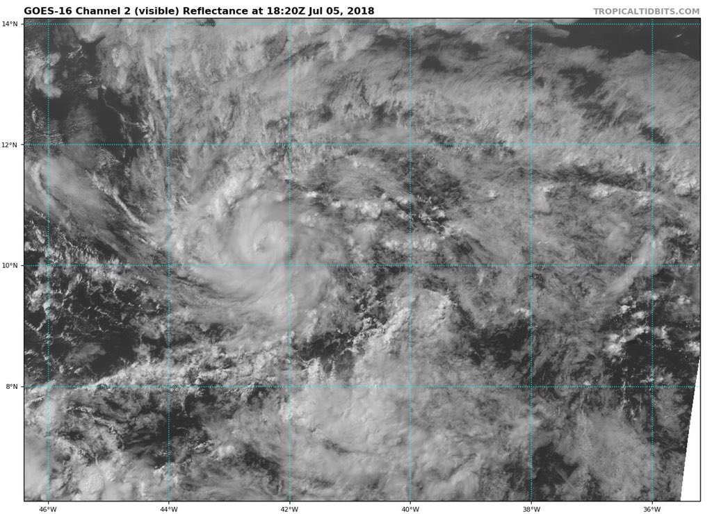
LOCATION...10.3N 42.8W
ABOUT 1295 MI...2080 KM ESE OF THE LESSER ANTILLES
MAXIMUM SUSTAINED WINDS...50 MPH...85 KM/H
PRESENT MOVEMENT...W OR 275 DEGREES AT 16 MPH...26 KM/H
MINIMUM CENTRAL PRESSURE...1004 MB...29.65 INCHES
WATCHES AND WARNINGS
--------------------
There are no coastal watches or warnings in effect.
DISCUSSION AND OUTLOOK
----------------------
At 500 PM AST (2100 UTC), the center of Tropical Storm Beryl was
located near latitude 10.3 North, longitude 42.8 West. Beryl is
moving toward the west near 16 mph (26 km/h). A fast westward to
west-northwestward motion is expected through the weekend. On the
forecast track, the center of Beryl will remain east of the Lesser
Antilles through Sunday.
Maximum sustained winds have increased to near 50 mph (85 km/h)
with higher gusts. Additional strengthening is forecast, and Beryl
could become a hurricane by Friday or Saturday. Beryl is forecast
to degenerate into an open trough just east of the Lesser Antilles
over the weekend.
Beryl is a tiny tropical storm. Tropical-storm-force winds extend
outward up to 35 miles (55 km) from the center.
The estimated minimum central pressure is 1004 mb (29.65 inches).
HAZARDS AFFECTING LAND
----------------------
None
NEXT ADVISORY
-------------
Next complete advisory at 1100 PM AST.
$$
Forecaster Berg
Tropical Storm Beryl Advisory Number 2
NWS National Hurricane Center Miami FL AL022018
500 PM AST Thu Jul 05 2018
...TINY BERYL STRENGTHENING OVER THE TROPICAL ATLANTIC...
SUMMARY OF 500 PM AST...2100 UTC...INFORMATION
----------------------------------------------
LOCATION...10.3N 42.8W
ABOUT 1295 MI...2080 KM ESE OF THE LESSER ANTILLES
MAXIMUM SUSTAINED WINDS...50 MPH...85 KM/H
PRESENT MOVEMENT...W OR 275 DEGREES AT 16 MPH...26 KM/H
MINIMUM CENTRAL PRESSURE...1004 MB...29.65 INCHES
WATCHES AND WARNINGS
--------------------
There are no coastal watches or warnings in effect.
DISCUSSION AND OUTLOOK
----------------------
At 500 PM AST (2100 UTC), the center of Tropical Storm Beryl was
located near latitude 10.3 North, longitude 42.8 West. Beryl is
moving toward the west near 16 mph (26 km/h). A fast westward to
west-northwestward motion is expected through the weekend. On the
forecast track, the center of Beryl will remain east of the Lesser
Antilles through Sunday.
Maximum sustained winds have increased to near 50 mph (85 km/h)
with higher gusts. Additional strengthening is forecast, and Beryl
could become a hurricane by Friday or Saturday. Beryl is forecast
to degenerate into an open trough just east of the Lesser Antilles
over the weekend.
Beryl is a tiny tropical storm. Tropical-storm-force winds extend
outward up to 35 miles (55 km) from the center.
The estimated minimum central pressure is 1004 mb (29.65 inches).
HAZARDS AFFECTING LAND
----------------------
None
NEXT ADVISORY
-------------
Next complete advisory at 1100 PM AST.
$$
Forecaster Berg
emh- huracan es simplemente ahora Edgardo. Importante: Phil Klotzbach, recordó que "el mejor momento para prepararse para los huracanes es cuando todavía no hay huracanes".

Re: Tormenta Tropical Beryl
Diantre!!! Esto puede ser huracán
Re: Tormenta Tropical Beryl
Diantre!!! Esto puede ser huracán
Re: Tormenta Tropical Beryl
WTNT42 KNHC 052018
TCDAT2
Tropical Storm Beryl Discussion Number 2
NWS National Hurricane Center Miami FL AL022018
500 PM AST Thu Jul 05 2018
Beryl has been a bit of a surprise today, which is not uncommon for
tiny tropical cyclones such as itself. A 1724 UTC SSMI microwave
pass and a 1853 UTC SSMI/S pass both revealed that the cyclone had
developed a well-defined 5 nmi-wide mid-level eye, and a dimple has
been apparent in visible satellite imagery. It's usually difficult
to get a good handle on the intensity of these types of cyclones
given their small size, but data-T numbers from TAFB and SAB are a
consensus T3.0. The initial intensity is therefore raised to 45 kt,
but there is a lot of uncertainty in this estimate.
If the initial intensity is uncertain, the future intensity is even
more of a quandary. Despite being surrounded by abundant dry air,
Beryl has apparently been able to isolate itself and possibly
moisten the near-storm environment while located in an area of low
shear. Since the shear is expected to remain quite low for the next
36 hours or so, and small cyclones like Beryl often have a tendency
to strengthen quickly over a short period of time, continued
intensification appears likely for the next day or so. The updated
NHC intensity forecast most closely follows the statistical-
dynamical guidance, which lies at the upper end of the guidance
envelope, and brings Beryl to hurricane strength within 36 hours.
After that time, increasing westerly shear, partially due to Beryl
accelerating toward the west, is expected to cause weakening. In
addition, every global model shows the cyclone opening up into a
tropical wave in 72-96 hours, which is what the NHC forecast
continues to depict. It cannot be stressed enough, however, that
this is a low confidence forecast.
The one stable part of the forecast is Beryl's future track. The
new guidance has not changed much from the previous forecast cycle,
and it continues to show Beryl slowing down a bit during the next 24
hours, followed by a west-northwestward acceleration in 48-72 hours
due to a strengthening ridge to the north. The updated NHC track
forecast is just a bit south of the previous one and is closest to
the HCCA and Florida State Superensemble guidance.
Even though Beryl is expected to dissipate just east of the Lesser
Antilles early next week, the remnant tropical wave will continue
moving quickly westward and will likely bring locally heavy
rains and gusty winds to portions of the Leeward Islands on Sunday
and Monday.
Key Messages:
1. Due to its very small size, there is greater-than-usual
uncertainty in the analysis of Beryl's current intensity.
Confidence in the official intensity forecast is also much lower
than normal. Rapid changes in intensity, both up and down, that are
difficult to predict are possible during the next couple of days.
2. While Beryl is still expected to dissipate as a tropical cyclone
by Monday before reaching the Lesser Antilles, there will likely
be some rain and wind impacts on those islands early next week.
Residents there should monitor products from their local weather
office for more information.
FORECAST POSITIONS AND MAX WINDS
INIT 05/2100Z 10.3N 42.8W 45 KT 50 MPH
12H 06/0600Z 10.8N 44.5W 55 KT 65 MPH
24H 06/1800Z 11.4N 46.3W 60 KT 70 MPH
36H 07/0600Z 12.1N 48.3W 65 KT 75 MPH
48H 07/1800Z 13.0N 51.0W 60 KT 70 MPH
72H 08/1800Z 14.5N 58.4W 50 KT 60 MPH
96H 09/1800Z...DISSIPATED
$$
Forecaster Berg
-
YankeeStorm
- Invest
- Posts: 117
- Joined: Tue Aug 06, 2013 11:30 pm
- Location: Yankees 27 Championships - Red Sox 3 Championships