
Huracán María


Re: Huracán María
ZCZC MIATCPAT5 ALL TTAA00 KNHC DDHHMM BULLETIN Hurricane Maria Advisory Number 17 NWS National Hurricane Center Miami FL AL152017 500 AM AST Wed Sep 20 2017 ...CORE OF EXTREMELY DANGEROUS HURRICANE MARIA NEARING PUERTO RICO... SUMMARY OF 500 AM AST...0900 UTC...INFORMATION ---------------------------------------------- LOCATION...17.9N 65.6W ABOUT 15 MI...25 KM SSW OF VIEQUES ABOUT 50 MI...75 KM SE OF SAN JUAN PUERTO RICO MAXIMUM SUSTAINED WINDS...155 MPH...250 KM/H PRESENT MOVEMENT...NW OR 305 DEGREES AT 10 MPH...17 KM/H MINIMUM CENTRAL PRESSURE...917 MB...27.08 INCHES WATCHES AND WARNINGS -------------------- CHANGES WITH THIS ADVISORY: The government of France has discontinued the Tropical Storm Warning for Guadeloupe. The government of the Bahamas has issued a Hurricane Warning for the Turks and Caicos Islands and the Southeastern Bahamas. The government of the Netherlands has discontinued the Hurricane Watch for Saba and St. Eustatius. SUMMARY OF WATCHES AND WARNINGS IN EFFECT: A Hurricane Warning is in effect for... * U.S. Virgin Islands * British Virgin Islands * Puerto Rico, Culebra, and Vieques * Dominican Republic from Cabo Engano to Puerto Plata * Turks and Caicos Islands and the Southeastern Bahamas A Tropical Storm Warning is in effect for... * Saba * St. Maarten * Dominican Republic west of Puerto Plata to the northern border of the Dominican Republic and Haiti * Dominican Republic west of Cabo Engano to Punta Palenque A Hurricane Watch is in effect for... * St. Maarten * St. Martin and St. Barthelemy * Dominican Republic from Isla Saona to Cabo Engano A Hurricane Warning means that hurricane conditions are expected somewhere within the warning area. Preparations to protect life and property should be rushed to completion. A Tropical Storm Warning means that tropical storm conditions are expected somewhere within the warning area. A Hurricane Watch means that hurricane conditions are possible within the watch area. A watch is typically issued 48 hours before the anticipated first occurrence of tropical-storm-force winds, conditions that make outside preparations difficult or dangerous. Interests elsewhere in Hispaniola and the Bahamas should monitor the progress of Maria. For storm information specific to your area in the United States, including possible inland watches and warnings, please monitor products issued by your local National Weather Service forecast office. For storm information specific to your area outside the United States, please monitor products issued by your national meteorological service. DISCUSSION AND 48-HOUR OUTLOOK ------------------------------ At 500 AM AST (0900 UTC), the center of Hurricane Maria was located near latitude 17.9 North, longitude 65.6 West. Maria is moving toward the northwest near 10 mph (17 km/h). A west-northwest to northwest motion is expected to continue through today, followed by a northwestward motion on Thursday. On the forecast track the eye of Maria will make landfall in Puerto Rico in a couple of hours, cross Puerto Rico today, and pass just north of the northeast coast of the Dominican Republic tonight and Thursday. Maximum sustained winds are near 155 mph (250 km/h) with higher gusts. Maria is an extremely dangerous category 4 hurricane on the Saffir-Simpson Hurricane Wind Scale, and it should maintain this intensity until landfall. Hurricane-force winds extend outward up to 60 miles (95 km) from the center and tropical-storm-force winds extend outward up to 150 miles (240 km). Fajardo recently reported sustained winds of 79 mph (128 km/h) with a gust to 100 mph (161 km/h). The minimum central pressure recently reported by an Air Force Hurricane Hunter aircraft is 917 mb (27.08 inches). HAZARDS AFFECTING LAND ---------------------- WIND: Tropical storm and hurricane conditions are occurring over the Virgin Islands and are spreading over Puerto Rico. Hurricane conditions are expected within the Hurricane Warning area in the Dominican Republic tonight, with tropical storm conditions expected by later today. Tropical storm conditions are expected in the Tropical Storm Warning areas in the Dominican Republic later today. Hurricane conditions are expected within the Hurricane Warning area by late Thursday in the Turks and Caicos Islands and the southeastern Bahamas, with tropical storm conditions in this area by early Thursday. Wind speeds atop and on the windward sides of hills and mountains and on high-rise buildings could be much stronger than the near- surface winds indicated in this advisory. STORM SURGE: A dangerous storm surge accompanied by large and destructive waves will raise water levels by as much as 4 to 6 feet above normal tide levels in the hurricane warning area in the Dominican Republic, and 1 to 3 ft elsewhere along the northern coasts of the Dominican Republic and Haiti. A dangerous storm surge accompanied by large and destructive waves will raise water levels by as much as 10 to 15 feet above normal tide levels in the Hurricane Warning area near and to the north of the center of Maria for both the Southeastern Bahamas and the Turks and Caicos Islands. The combination of a dangerous storm surge and the tide will cause normally dry areas near the coast to be flooded by rising waters moving inland from the shoreline. The water is expected to reach the following heights above ground if the peak surge occurs at the time of high tide... Puerto Rico and the U.S. Virgin Islands...6 to 9 ft The deepest water will occur along the immediate coast near and to the north and east of the landfall location, where the surge will be accompanied by large and destructive waves. Surge-related flooding depends on the relative timing of the surge and the tidal cycle, and can vary greatly over short distances. For information specific to your area, please see products issued by your local National Weather Service forecast office. RAINFALL: Maria is expected to produce the following rain accumulations through Friday: Central Leeward Islands...additional 1 to 2 inches. Northern Leeward Islands from Barbuda to Anguilla...additional 2 to 5 inches. U.S. and British Virgin Islands...additional 8 to 12 inches, isolated 16 inches. Puerto Rico...12 to 18 inches, isolated 25 inches. Northern and eastern Dominican Republic and Turks and Caicos...4 to 8 inches, isolated 12 inches. Northern Haiti and southeastern Bahamas...2 to 4 inches. Rainfall on these islands will cause life-threatening flash floods and mudslides. TORNADOES: Several tornadoes are possible over Puerto Rico and the U.S. Virgin Islands today. THE EYE: Do not venture outside when the calm eye of the hurricane passes over, as dangerous winds will return very quickly when the eye moves away. SURF: Swells generated by Maria are affecting the Leeward Islands, Puerto Rico, and the Virgin Islands. These swells will begin affecting the northern coast of Hispaniola, the Turks and Caicos Islands, and the Southeastern Bahamas during the next day or two. These swells are likely to cause life-threatening surf and rip current conditions. Please consult products from your local weather office. NEXT ADVISORY ------------- Next intermediate advisory at 800 AM AST. Next complete advisory at 1100 AM AST. $$ Forecaster Pasch NNNN
Re: Huracán María
A punto de hacer landfall 

Re: Huracán María
Alguien por ahi que informe como esta la cosa??? Vivo en Florida pero toda mi familia esta en PR y estoy preocupada... 
Re: Huracán María
Acabo de escuchar un ruido infernal detrás de la casa!__Acaba de caer un techo completo de zinc en mi patio...espero que la persona o la familia que viviera en cuya casa cobijaba se encuentre a buen resguardo en un refugio o una residencia más segura...supongo que es así porque no se escucha a nadie que pidiera ayuda ni nada.
Ufff...ta feo esto!...acaba de caer algo heavy nuevamente...ni idea de lo que pueda ser, no pienso abrir la ventana porque proviene de la dirección que sopla el viento.
Ufff...ta feo esto!...acaba de caer algo heavy nuevamente...ni idea de lo que pueda ser, no pienso abrir la ventana porque proviene de la dirección que sopla el viento.
Re: Huracán María
Ahora juzgar por lo que veo...al menos el área de San turco, donde vivo, tendrá un aspecto diferente cuando todo haya pasado.
Estamos bajo asedio total!__Es como una guerra donde no puedes atacar...solo puedes intentar defenderte.
Pero yo sigo vivo y bien...esto no va a durar para siempre, su familia igual va a estar bien, con Dios por delante.
Mis mejores deseos para ..oh Dios, voy a tener que moverme!
Mis mejores deseos para usted y su familia...es solo un mal día...terrible, pero va a pasar.
Re: Huracán María
Muchas gracias David por responder. Espero que tambien usted siga bien se mantenga seguro. Orando por todo mi Puerto Rico. Dios me los ayude y acompañe siempre.
David cuidese mucho que siempre estoy leyendo todos sus analisis en este foro y me agrada mucho siempre sus referencias con los tiempos de "nantes".
David cuidese mucho que siempre estoy leyendo todos sus analisis en este foro y me agrada mucho siempre sus referencias con los tiempos de "nantes".
David1979 wrote: ↑Wed Sep 20, 2017 6:07 amAhora juzgar por lo que veo...al menos el área de San turco, donde vivo, tendrá un aspecto diferente cuando todo haya pasado.
Estamos bajo asedio total!__Es como una guerra donde no puedes atacar...solo puedes intentar defenderte.
Pero yo sigo vivo y bien...esto no va a durar para siempre, su familia igual va a estar bien, con Dios por delante.
Mis mejores deseos para ..oh Dios, voy a tener que moverme!
Mis mejores deseos para usted y su familia...es solo un mal día...terrible, pero va a pasar.
-
Georges_98
- Invest

- Posts: 227
- Joined: Fri Sep 02, 2016 2:27 am
Re: Huracán María
María ha completado el reemplazo del ojo. Su intensidad ha disminuido por debajo de los 250 km/hora. Está entrando a la isla en lo justo para mantenerse como Cat 5.
-
StormWatch
- Cat. 3

- Posts: 3721
- Joined: Thu Aug 06, 2015 11:39 am
- Location: Texas, USA
Re: Huracán María
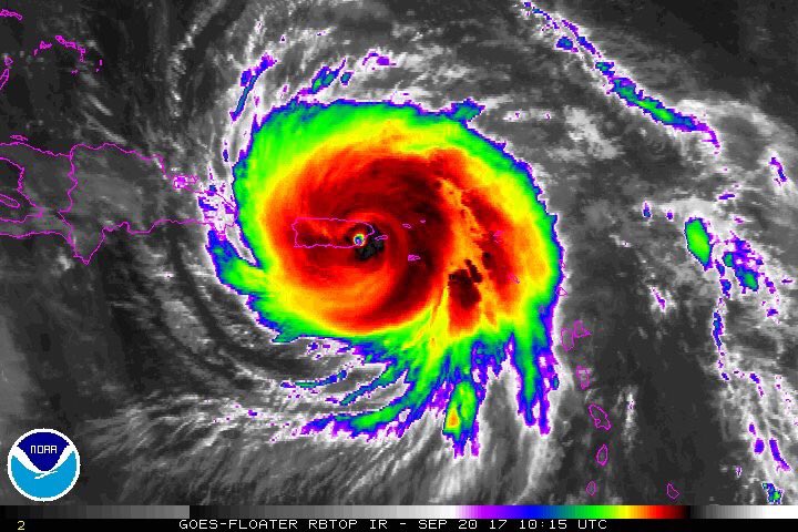
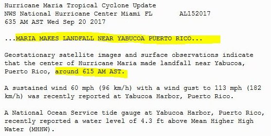
Hurricane Maria makes landfall over Yabucoa with winds near 155 mph, the strongest hurricane to make landfall in Puerto Rico since 1928.
Yabucoa, Puerto Rico

Zip Code 00767
September 20, 2017
Yabucoa, Puerto Rico
Zip Code 00767
September 20, 2017
Member Since 2005
For official information, please refer to NHC: https://www.nhc.noaa.gov
Hurricane’s hit Puerto Rico:
San Felipe 1928, San Ciprián 1932, Santa Clara 1956, Hugo 1989, Marilyn 1995, Hortense 1996, Georges 1998, Maria 2017, Fiona 2022
Model Runs:
GFS:
[5:30 AM/PM, 11:30 AM/PM]
HWRF, GFDL, UKMET, NAVGEM:
[6:30-8:00 AM/PM, 12:30-2:00 AM/PM]
ECMWF:
[1:45 AM/PM]
-
StormWatch
- Cat. 3
- Posts: 3721
- Joined: Thu Aug 06, 2015 11:39 am
- Location: Texas, USA
Re: Huracán María
Official statement from NHC about Hurricane Maria making landfall this morning!
Hurricane Maria
September 20, 2017
Hurricane Maria
September 20, 2017
Member Since 2005
For official information, please refer to NHC: https://www.nhc.noaa.gov
Hurricane’s hit Puerto Rico:
San Felipe 1928, San Ciprián 1932, Santa Clara 1956, Hugo 1989, Marilyn 1995, Hortense 1996, Georges 1998, Maria 2017, Fiona 2022
Model Runs:
GFS:
[5:30 AM/PM, 11:30 AM/PM]
HWRF, GFDL, UKMET, NAVGEM:
[6:30-8:00 AM/PM, 12:30-2:00 AM/PM]
ECMWF:
[1:45 AM/PM]
For official information, please refer to NHC: https://www.nhc.noaa.gov
Hurricane’s hit Puerto Rico:
San Felipe 1928, San Ciprián 1932, Santa Clara 1956, Hugo 1989, Marilyn 1995, Hortense 1996, Georges 1998, Maria 2017, Fiona 2022
Model Runs:
GFS:
[5:30 AM/PM, 11:30 AM/PM]
HWRF, GFDL, UKMET, NAVGEM:
[6:30-8:00 AM/PM, 12:30-2:00 AM/PM]
ECMWF:
[1:45 AM/PM]
-
Georges_98
- Invest
- Posts: 227
- Joined: Fri Sep 02, 2016 2:27 am
Re: Huracán María
Justo ahora María completando su entrada por Yabucoa, con vientos de 250 km/hora y con 917 mb.