Aquí encontrarás todo lo relacionado al la meteorología en Puerto Rico y las condiciones del tiempo actuales, así como los huracanes que se desarrollen durante las temporadas ciclónicas, actualizados por expertos y aficionados a la meteorología de todo el pais! Este es tu foro! Leelo, escribe en el y disfrútalo! Cycloman.
Hurricane’s hit Puerto Rico: San Felipe 1928, San Ciprián 1932, Santa Clara 1956, Hugo 1989, Marilyn 1995, Hortense 1996, Georges 1998, Maria 2017, Fiona 2022
Regreso mas tarde si hay energia electrica y/o no estan Las cosas dificiles.
"Georgy Girl", The Seekers
"Back for Good", Take That "Perfectionist", SAGA
"Graves Into Gardens", Elevation Worship ft. Brandon Lake
"Thunder", Imagine Dragons
"Viva la Vida", Coldplay
Hurricane’s hit Puerto Rico: San Felipe 1928, San Ciprián 1932, Santa Clara 1956, Hugo 1989, Marilyn 1995, Hortense 1996, Georges 1998, Maria 2017, Fiona 2022
Prioridad ahora es la familia y orar que no sea esto tan dificil.
Un abrazo a todos.
"Georgy Girl", The Seekers
"Back for Good", Take That "Perfectionist", SAGA
"Graves Into Gardens", Elevation Worship ft. Brandon Lake
"Thunder", Imagine Dragons
"Viva la Vida", Coldplay
Nunca tuve duda de la ruta de este ciclon. Si de la intensidad. Jamas pense en este escenario. Esperaba un cat 2 fuerte o cat 3.Esto sobrepasa todo lo pensado.
Mis condolencias tambien a Mejico. Increible lo que ocurre alla con el terremoto acontecido hoy. La tierra esta enfurecida y esta reclamando su lugar.
BULLETIN
Hurricane Maria Intermediate Advisory Number 15A
NWS National Hurricane Center Miami FL AL152017
800 PM AST Tue Sep 19 2017
...EYE OF CATEGORY 5 HURRICANE MARIA MOVING CLOSER TO ST CROIX IN
THE U.S. VIRGIN ISLANDS...
...PREPARATIONS AGAINST LIFE-THREATENING STORM SURGE AND RAINFALL
FLOODING AND DESTRUCTIVE WINDS SHOULD BE RUSHED TO COMPLETION...
SUMMARY OF 800 PM AST...0000 UTC...INFORMATION
----------------------------------------------
LOCATION...17.0N 64.2W
ABOUT 60 MI...100 KM SE OF ST. CROIX
ABOUT 160 MI...255 KM SE OF SAN JUAN PUERTO RICO
MAXIMUM SUSTAINED WINDS...175 MPH...280 KM/H
PRESENT MOVEMENT...WNW OR 300 DEGREES AT 10 MPH...17 KM/H
MINIMUM CENTRAL PRESSURE...909 MB...26.84 INCHES
WATCHES AND WARNINGS
--------------------
CHANGES WITH THIS ADVISORY:
The Meteorological Service of Antigua has discontinued the
Hurricane Warning for St. Kitts, Nevis, and Montserrat. The
Tropical Storm Warning and Hurricane Watch for Anguilla has also
been discontinued.
SUMMARY OF WATCHES AND WARNINGS IN EFFECT:
A Hurricane Warning is in effect for...
* U.S. Virgin Islands
* British Virgin Islands
* Puerto Rico, Culebra, and Vieques
* Dominican Republic from Cabo Engano to Puerto Plata
A Tropical Storm Warning is in effect for...
* Saba and St. Eustatius
* St. Maarten
* Guadeloupe
* Dominican Republic west of Puerto Plata to the northern border of
the Dominican Republic and Haiti
* Dominican Republic west of Cabo Engano to Punta Palenque
A Hurricane Watch is in effect for...
* Saba and St. Eustatius
* St. Maarten
* St. Martin and St. Barthelemy
* Isla Saona to Cabo Engano
* Turks and Caicos Islands and the Southeastern Bahamas
A Hurricane Warning means that hurricane conditions are expected
somewhere within the warning area. Preparations to protect life and
property should be rushed to completion.
A Tropical Storm Warning means that tropical storm conditions are
expected somewhere within the warning area.
A Hurricane Watch means that hurricane conditions are possible
within the watch area. A watch is typically issued 48 hours before
the anticipated first occurrence of tropical-storm-force winds,
conditions that make outside preparations difficult or dangerous.
Interests elsewhere in Hispaniola and the Bahamas should monitor the
progress of Maria.
For storm information specific to your area in the United
States, including possible inland watches and warnings, please
monitor products issued by your local National Weather Service
forecast office. For storm information specific to your area outside
the United States, please monitor products issued by your national
meteorological service.
DISCUSSION AND 48-HOUR OUTLOOK
------------------------------
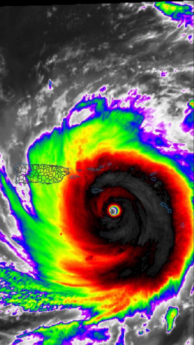
At 800 PM AST (0000 UTC), the eye of Hurricane Maria was located
near latitude 17.0 North, longitude 64.2 West. Maria is moving
toward the west-northwest near 10 mph (17 km/h), and this general
motion is expected to continue through Wednesday night. On the
forecast track, the eye of Maria will move near or over St. Croix
in the U.S. Virgin Islands tonight, cross Puerto Rico on Wednesday,
and then pass just north of the coast of the Dominican Republic
Wednesday night and Thursday.
Reports from an Air Force Reserve Hurricane Hunter aircraft
indicate that maximum sustained winds are near 175 mph (280 km/h)
with higher gusts. Maria is a potentially catastrophic category
5 hurricane on the Saffir-Simpson Hurricane Wind Scale. Some
fluctuations in intensity are likely during the next day or so, but
Maria is forecast to remain an extremely dangerous category 4 or 5
hurricane as it moves near or over the Virgin Islands and Puerto
Rico. Slow weakening is expected after the hurricane emerges over
the Atlantic north of Puerto Rico and the Dominican Republic.
Hurricane-force winds extend outward up to 35 miles (55 km) from
the center and tropical-storm-force winds extend outward up to 140
miles (220 km).
The latest minimum central pressure reported by the Hurricane
Hunter aircraft is 909 mb (26.84 inches).
HAZARDS AFFECTING LAND
----------------------
WIND: Hurricane and tropical storm conditions will continue in
portions of the warning area in the Leeward Islands this evening,
and spread into the Virgin Islands and Puerto Rico tonight and
Wednesday. Tropical storm conditions are spreading over the Virgin
Islands at this time. Tropical storm conditions should begin
spreading over Puerto Rico within the next few hours. Hurricane
conditions are expected within the hurricane warning area in the
Dominican Republic late Wednesday, with tropical storm conditions
expected by early Wednesday. Tropical storm conditions are expected
in the tropical storm warning areas in the Dominican Republic on
Wednesday. Hurricane and tropical storm conditions are possible on
Thursday in the Turks and Caicos Islands and the southeastern
Bahamas.
Wind speeds atop and on the windward sides of hills and mountains
and on high-rise buildings could be much stronger than the near-
surface winds indicated in this advisory.
STORM SURGE: A dangerous storm surge accompanied by large and
destructive waves will raise water levels by as much as 7 to 11
feet above normal tide levels in the hurricane warning area near
where the center of Maria moves across the Leeward Islands and the
British Virgin Islands.
A dangerous storm surge accompanied by large and destructive waves
will raise water levels by as much as 4 to 6 feet above normal tide
levels in the hurricane warning area in the Dominican Republic, and
1 to 3 ft elsewhere along the northern coasts of the Dominican
Republic and Haiti.
The combination of a dangerous storm surge and the tide will cause
normally dry areas near the coast to be flooded by rising waters
moving inland from the shoreline. The water is expected to reach
the following heights above ground if the peak surge occurs at the
time of high tide...
Puerto Rico and the U.S. Virgin Islands...6 to 9 ft
The deepest water will occur along the immediate coast near and to
the north and east of the landfall location, where the surge will be
accompanied by large and destructive waves. Surge-related
flooding depends on the relative timing of the surge and the tidal
cycle, and can vary greatly over short distances. For information
specific to your area, please see products issued by your local
National Weather Service forecast office.
RAINFALL: Maria is expected to produce the following rain
accumulations through Thursday:
Central and southern Leeward Islands...10 to 15 inches, isolated 20
inches.
U.S. and British Virgin Islands...10 to 15 inches, isolated 20
inches.
Puerto Rico...12 to 18 inches, isolated 25 inches.
Northern Leeward Islands from Barbuda to Anguilla...4 to 8 inches,
isolated 10 inches.
Windward Islands and Barbados...2 to 4 inches, isolated 6 inches.
Eastern Dominican Republic...4 to 8 inches, isolated 12 inches.
Rainfall on all of these islands will cause life-threatening flash
floods and mudslides.
TORNADOES: Several tornadoes are possible over Puerto Rico and the
U. S. Virgin Islands tonight and Wednesday.
SURF: Swells generated by Maria are affecting the Leeward Islands,
Puerto Rico, and the Virgin Islands. These swells are likely to
cause life-threatening surf and rip current conditions. Please
consult products from your local weather office.
NEXT ADVISORY
-------------
Next complete advisory at 1100 PM AST.
Hurricane’s hit Puerto Rico: San Felipe 1928, San Ciprián 1932, Santa Clara 1956, Hugo 1989, Marilyn 1995, Hortense 1996, Georges 1998, Maria 2017, Fiona 2022
Venía Juracán ¿y el jíbaro que jacia? recogia la familia y a la tormentera se metía. Pasaba Juracán y de hambre no moría, ñame, malanga y yautia. El agua, del manantial siempre fría . Pa comé el fogón se prendía y en la noche con un quinqué y jacho la Luz venía. Hoy vivimos asustaos con tanta tecnología y enantes el jíbaro con poco muy feliz que vivía.
Hurricane’s hit Puerto Rico: San Felipe 1928, San Ciprián 1932, Santa Clara 1956, Hugo 1989, Marilyn 1995, Hortense 1996, Georges 1998, Maria 2017, Fiona 2022