Aquí encontrarás todo lo relacionado al la meteorología en Puerto Rico y las condiciones del tiempo actuales, así como los huracanes que se desarrollen durante las temporadas ciclónicas, actualizados por expertos y aficionados a la meteorología de todo el pais! Este es tu foro! Leelo, escribe en el y disfrútalo! Cycloman.
Hurricane’s hit Puerto Rico: San Felipe 1928, San Ciprián 1932, Santa Clara 1956, Hugo 1989, Marilyn 1995, Hortense 1996, Georges 1998, Maria 2017, Fiona 2022
StormWatch wrote: ↑Sun Sep 17, 2017 5:29 am
Buenos días!
Creo q si PR entra en ese cono.......Salvar vida y propiedad!
Esto esta cada vez menos esperanzador para nosotros aqui!
Disclaimer: "Solo soy otro fan de la meteorolgia...para informacion mas precisa vaya a buscarla del NHC y del SNM.... No soy la voz oficial de comunicaciones de la AAA asi que pendiente a sus anuncios oficiales en los medios de comunicación de prensa escrita, radial, televisiva, redes socials, etc."
Hurricane’s hit Puerto Rico: San Felipe 1928, San Ciprián 1932, Santa Clara 1956, Hugo 1989, Marilyn 1995, Hortense 1996, Georges 1998, Maria 2017, Fiona 2022
Area Forecast Discussion
National Weather Service San Juan PR
606 AM AST Sun Sep 17 2017
.SYNOPSIS...Maria could affect the U.S. Virgin Islands and Puerto
Rico by mid week as a dangerous major hurricane. Interests in
these areas should monitor the progress of Maria and follow any
advice given by local officials.
&&
.SHORT TERM...Today through Tuesday
Variably cloudy skies prevailed across Puerto Rico, Culebra,
Vieques and the U.S. Virgin Islands overnight. Some showers with
isolated thunderstorms were observed near Saint John and Saint
Thomas and also across the offshore waters near Saint Croix.
Meanwhile, only some passing showers were observed across the east
section of Puerto Rico. This activity was primarily associated
with an upper level trough which was located across the Caribbean
waters early this morning. This upper level feature will continue
to retrograde west moving away from the region today. However,
available moisture will combine with strong daytime heating and
orographic effects to produce scattered showers with isolated
thunderstorms over the western interior, north central and
northwest sections of Puerto Rico.
For Monday, wind shifts northeast ahead of tropical cyclone Maria.
Therefore, showers and thunderstorms are forecast to develop across
the southwestern section of Puerto Rico. Meanwhile across the U.S.
Virgin Islands, dry weather conditions are expected. For Tuesday,
Tropical Cyclone Maria will approach the local region. Very active
weather in rainbands will spread across the U.S. Virgin Islands
starting as early as Tuesday morning and continuing throughout the
day on Tuesday.
.LONG TERM...Wednesday through Monday
Tropical storm force winds are likely as early as Tuesday morning
across the US Virgin Islands, Culebra and Vieques and by Tuesday
evening across Puerto Rico. As Maria moves across the northeast
Caribbean; dangerous wind, storm surge and rainfall hazards are
expected. Based on the latest forecast from the NHC, the environment
should be conducive for continued strengthening with low shear, a
warm ocean and a fairly moist mid- tropospheric air mass. As a
result, Maria could affect the U.S. Virgin Islands and Puerto Rico
by mid week as a dangerous major hurricane. Hurricane watches
could be issued as early as tonight. Interests across the local
islands should monitor the progress of Maria and follow any advice
given by local officials.
Although Maria is expected to move away by Thursday, plenty of
moisture will remain across the local islands to result in showers
and thunderstorms each day. A drier air mass is expected to move
in early next week.
BULLETIN
Tropical Storm Maria Intermediate Advisory Number 4A
NWS National Hurricane Center Miami FL AL152017
800 AM AST Sun Sep 17 2017
...MARIA EXPECTED TO BECOME A HURRICANE LATER TODAY...
SUMMARY OF 800 AM AST...1200 UTC...INFORMATION
----------------------------------------------
LOCATION...13.3N 55.6W
ABOUT 410 MI...655 KM ESE OF THE LESSER ANTILLES
MAXIMUM SUSTAINED WINDS...65 MPH...100 KM/H
PRESENT MOVEMENT...WNW OR 290 DEGREES AT 15 MPH...24 KM/H
MINIMUM CENTRAL PRESSURE...994 MB...29.36 INCHES
WATCHES AND WARNINGS
--------------------
CHANGES WITH THIS ADVISORY:
The government of France has issued a Hurricane Watch for St.
Martin and St. Barthelemy.
SUMMARY OF WATCHES AND WARNINGS IN EFFECT:
A Hurricane Watch is in effect for...
* Antigua, Barbuda, St. Kitts, Nevis, and Montserrat
* Guadeloupe
* Dominica
* Saba and St. Eustatius
* St. Maarten
* St. Martin and St. Barthelemy
* Anguilla
A Tropical Storm Watch is in effect for...
* St. Lucia
* Martinique
* Barbados
* St. Vincent and the Grenadines
A Hurricane Watch means that hurricane conditions are possible
within the watch area. A watch is typically issued 48 hours
before the anticipated first occurrence of tropical-storm-force
winds, conditions that make outside preparations difficult or
dangerous.
A Tropical Storm Watch means that tropical storm conditions are
possible within the watch area, generally within 48 hours.
Interests elsewhere in the Lesser Antilles and the British and U. S.
Virgin Islands should monitor the progress of this system.
Additional Tropical Storm or Hurricane Watches and Warnings will
likely be issued today.
For storm information specific to your area, please monitor
products issued by your national meteorological service.
DISCUSSION AND 48-HOUR OUTLOOK
------------------------------
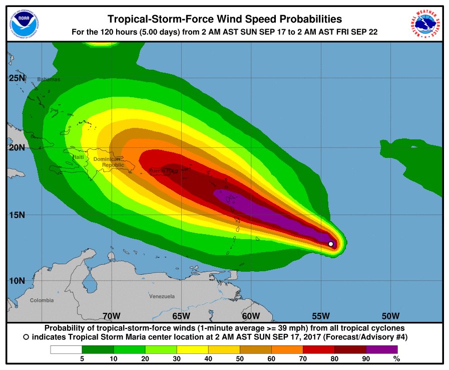
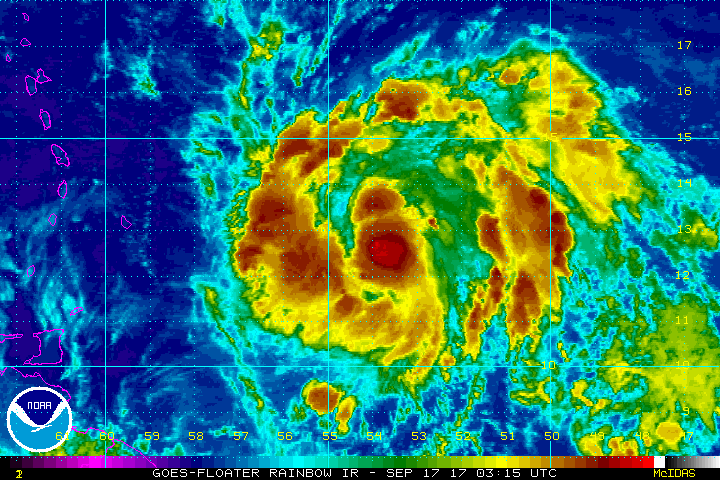
At 800 AM AST (1200 UTC), the center of Tropical Storm Maria was
located near latitude 13.3 North, longitude 55.6 West. Maria is
moving toward the west-northwest near 15 mph (24 km/h), and this
motion with a further reduction in forward speed is expected over
the next couple of days. On the forecast track, the center of Maria
will be near the Leeward Islands Monday night.
Maximum sustained winds are near 65 mph (100 km/h) with higher
gusts. Strengthening is forecast during the next 48 hours, and
Maria will likely become a hurricane later today.
Tropical-storm-force winds extend outward up to 60 miles (95 km)
from the center.
The estimated minimum central pressure is 994 mb (29.36 inches).
HAZARDS AFFECTING LAND
----------------------
WIND: Hurricane conditions are possible within the hurricane watch
area by Monday night or Tuesday, with tropical storm conditions
possible on Monday. Tropical storm conditions are possible in the
tropical storm watch area on Monday.
STORM SURGE: A dangerous storm surge accompanied by large and
destructive waves will raise water levels by as much as 3 to 5 feet
above normal tide levels within the hurricane watch area.
RAINFALL: Maria is expected to produce total rain accumulations of
6 to 12 inches with isolated maximum amounts of 20 inches across the
central and southern Leeward Islands through Wednesday night. Maria
is also expected to produce total rain accumulations of 2 to 4
inches with isolated maximum amounts of 8 inches in the northern
Leeward Islands and north-central Windward Islands. This rainfall
could cause life-threatening flash floods and mudslides.
SURF: Swells generated by Maria are expected to begin affecting the
Lesser Antilles by tonight. These swells are likely to cause
life-threatening surf and rip current conditions. Please consult
products from your local weather office.
NEXT ADVISORY
-------------
Next complete advisory at 1100 AM AST.
Hurricane’s hit Puerto Rico: San Felipe 1928, San Ciprián 1932, Santa Clara 1956, Hugo 1989, Marilyn 1995, Hortense 1996, Georges 1998, Maria 2017, Fiona 2022
Hurricane’s hit Puerto Rico: San Felipe 1928, San Ciprián 1932, Santa Clara 1956, Hugo 1989, Marilyn 1995, Hortense 1996, Georges 1998, Maria 2017, Fiona 2022


