Aquí encontrarás todo lo relacionado al la meteorología en Puerto Rico y las condiciones del tiempo actuales, así como los huracanes que se desarrollen durante las temporadas ciclónicas, actualizados por expertos y aficionados a la meteorología de todo el pais! Este es tu foro! Leelo, escribe en el y disfrútalo! Cycloman.
Obi-Wan wrote: ↑Wed Sep 06, 2017 9:26 pm
El partido se esta acabando ganando el equipo Europeo por varios puntos, las gradas se vacían y se acomodan en este nuevo juego poco a poco.
Nuevamente con un equipo Europeo acomodando una jugada mas al oeste que los adversarios.
Quien ganará en este nuevo partido? En algunos 5 días lo sabremos.
Somos unos pocos los que nunca dejamos solo a Jose, Stromwatch, David, este servidor por ejemplo.
Y seguro que si somos Team Euro
Para información oficial favor referirse a las agencias pertinentes. Un aficionado a la meteorología #TeamCycloforums
Hurricane’s hit Puerto Rico: San Felipe 1928, San Ciprián 1932, Santa Clara 1956, Hugo 1989, Marilyn 1995, Hortense 1996, Georges 1998, Maria 2017, Fiona 2022
BULLETIN
Hurricane Jose Advisory Number 7
NWS National Hurricane Center Miami FL AL122017
1100 PM AST Wed Sep 06 2017
...JOSE CONTINUES INTENSIFYING OVER THE CENTRAL ATLANTIC...
SUMMARY OF 1100 PM AST...0300 UTC...INFORMATION
-----------------------------------------------
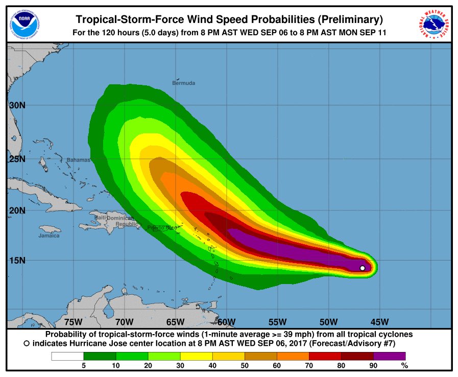
LOCATION...14.4N 47.5W
ABOUT 925 MI...1485 KM E OF THE LESSER ANTILLES
MAXIMUM SUSTAINED WINDS...85 MPH...140 KM/H
PRESENT MOVEMENT...WNW OR 290 DEGREES AT 17 MPH...28 KM/H
MINIMUM CENTRAL PRESSURE...989 MB...29.21 INCHES
WATCHES AND WARNINGS
--------------------
There are no coastal watches or warnings in effect.
Interests in the Leeward Islands should monitor the progress of
Jose.
DISCUSSION AND 48-HOUR OUTLOOK
------------------------------
At 1100 PM AST (0300 UTC), the center of Hurricane Jose was located
near latitude 14.4 North, longitude 47.5 West. Jose is moving toward
the west-northwest near 17 mph (28 km/h) and this motion is expected
to continue for the next two days.
Maximum sustained winds are near 85 mph (140 km/h) with higher
gusts. Some strengthening is forecast during the next 48 hours.
Hurricane-force winds extend outward up to 15 miles (30 km) from the
center and tropical-storm-force winds extend outward up to 80 miles
(130 km).
The estimated minimum central pressure is 989 mb (29.21 inches).
HAZARDS AFFECTING LAND
----------------------
None.
NEXT ADVISORY
-------------
Next complete advisory at 500 AM AST.
Hurricane’s hit Puerto Rico: San Felipe 1928, San Ciprián 1932, Santa Clara 1956, Hugo 1989, Marilyn 1995, Hortense 1996, Georges 1998, Maria 2017, Fiona 2022
Hurricane’s hit Puerto Rico: San Felipe 1928, San Ciprián 1932, Santa Clara 1956, Hugo 1989, Marilyn 1995, Hortense 1996, Georges 1998, Maria 2017, Fiona 2022
Hurricane’s hit Puerto Rico: San Felipe 1928, San Ciprián 1932, Santa Clara 1956, Hugo 1989, Marilyn 1995, Hortense 1996, Georges 1998, Maria 2017, Fiona 2022
Hurricane Jose Discussion Number 7
NWS National Hurricane Center Miami FL AL122017
1100 PM AST Wed Sep 06 2017
Jose's deep convection displays a tightly curved band that wraps at
least twelve-tenths around the center. Dvorak intensity estimates
from both TAFB and SAB have increased accordingly. Thus, maximum
sustained winds are analyzed for Jose at 75 kt, very close to that
from the CIMSS Advanced Dvorak Technique.
Jose is likely to continue developing during the next day or two
while the vertical shear is low, the SSTs are around 29C, and the
mid-level humidity is moist. However, beginning in two to three
days, the outflow from large, strong hurricane Irma to Jose's west
should start inducing more shear, inducing a steady weakening
by days four and five. The official intensity forecast is based upon
a blend of the LGEM, HWRF, and COAMPS models. Jose's anticipated
peak intensity of 105 kt is slightly higher than the previous
advisory, while days four and five show a more quickly weakening
system at that time.
The hurricane is moving toward the west-northwest around 15 kt, as
it is being advected along the south side of the deep-layer Bermuda
high. This motion should continue for the next couple of days.
During days three to five, Jose should bend toward the northwest as
it moves around the periphery of the Bermuda high. The official
track forecast is based upon the very tightly clustered guidance
(and their consensus technique - TVCN), which is somewhat west of
the previous advisory.
If future guidance further shifts westward, then tropical storm or
hurricane watches may be required for portions of the Leeward
Islands on Thursday.
Jose is a small hurricane with tropical-storm-force winds extending
out at most 70 nm from the center, based upon NDBC Buoy 41041 and
the 0006Z ASCAT-A scatterometer pass. The official size foreast -
based upon the RVCN consensus - suggests a gradual increase in size
for the next three days. Interestingly, buoy 41041 measured a
peak 1-minute wind (at 5 m anemometer height) of 61 kt around 22Z.
Hurricane’s hit Puerto Rico: San Felipe 1928, San Ciprián 1932, Santa Clara 1956, Hugo 1989, Marilyn 1995, Hortense 1996, Georges 1998, Maria 2017, Fiona 2022
Hurricane’s hit Puerto Rico: San Felipe 1928, San Ciprián 1932, Santa Clara 1956, Hugo 1989, Marilyn 1995, Hortense 1996, Georges 1998, Maria 2017, Fiona 2022