Page 32 of 34
Re: Remanentes de Harvey
Posted: Thu Aug 24, 2017 9:21 am
by StormWatch
CarlosP wrote: ↑Thu Aug 24, 2017 9:13 am
De onda a huracan en un día. Wow.
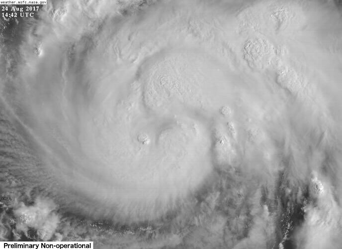
Bien brutal! Ya se nota un ojo!
Leí sobre 50 pulgadas de lluvia, catastrófico de ser así.

Re: Remanentes de Harvey
Posted: Thu Aug 24, 2017 10:58 am
by StormWatch
OMG!
954AM URGENT - Harvey now expected to be a MAJOR HURRICANE (Cat3+) when it makes landfall tomorrow in the Coastal Bend/Middle Coast. #txwx
Re: Remanentes de Harvey
Posted: Thu Aug 24, 2017 11:08 am
by StormWatch
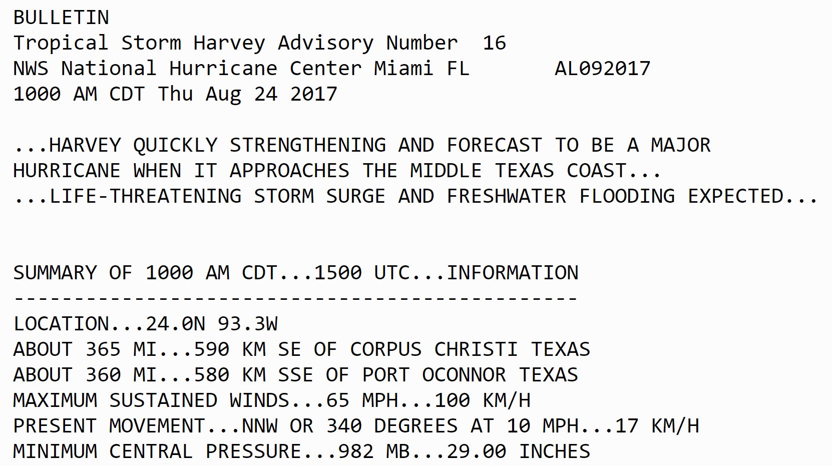
BULLETIN
Tropical Storm Harvey Advisory Number 16
NWS National Hurricane Center Miami FL AL092017
1000 AM CDT Thu Aug 24 2017
...HARVEY QUICKLY STRENGTHENING AND FORECAST TO BE A MAJOR
HURRICANE WHEN IT APPROACHES THE MIDDLE TEXAS COAST...
...LIFE-THREATENING STORM SURGE AND FRESHWATER FLOODING EXPECTED...
SUMMARY OF 1000 AM CDT...1500 UTC...IN
Re: Remanentes de Harvey
Posted: Thu Aug 24, 2017 11:09 am
by StormWatch
Que APARATO!
Re: Remanentes de Harvey
Posted: Thu Aug 24, 2017 11:16 am
by StormWatch
Yo espero q este HURACÁN NO LLEGUE A Aubrey! Shit

Casi casi se ve el ojo en formación

Re: Remanentes de Harvey
Posted: Thu Aug 24, 2017 11:19 am
by StormWatch
Harvey

Re: Remanentes de Harvey
Posted: Thu Aug 24, 2017 11:46 am
by StormWatch
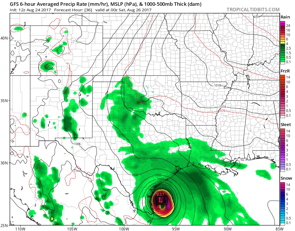
Today's 12Z GFS Op dropping the central minimum pressure of #Harvey down to 937mb in just 36 hours (1.3mb/hour) - Category 4 territory
Re: Remanentes de Harvey
Posted: Thu Aug 24, 2017 2:07 pm
by CarlosP
Hace tiempo no veía el warning de rapid intensification. Wow.
Re: Huracan Harvey
Posted: Thu Aug 24, 2017 2:26 pm
by Cycloneye
BULLETIN
Hurricane Harvey Special Advisory Number 17...CORRECTED
NWS National Hurricane Center Miami FL AL092017
100 PM CDT Thu Aug 24 2017
Corrected for extension of Storm Surge Warning
...HARVEY RAPIDLY INTENSIFYING...
...PREPARATIONS ALONG THE MIDDLE TEXAS COAST SHOULD BE RUSHED TO
COMPLETION TODAY...
SUMMARY OF 100 PM CDT...1800 UTC...INFORMATION
----------------------------------------------
LOCATION...24.4N 93.6W
ABOUT 335 MI...540 KM SE OF CORPUS CHRISTI TEXAS
ABOUT 325 MI...525 KM SSE OF PORT OCONNOR TEXAS
MAXIMUM SUSTAINED WINDS...85 MPH...140 KM/H
PRESENT MOVEMENT...NNW OR 335 DEGREES AT 10 MPH...17 KM/H
MINIMUM CENTRAL PRESSURE...979 MB...28.91 INCHES
Hurricane Harvey Special Discussion Number 17
NWS National Hurricane Center Miami FL AL092017
100 PM CDT Thu Aug 24 2017
This special advisory is being issued to update Harvey's initial
and forecast intensities through the 48-hour period. The storm
surge values in the public advisory have also been updated based on
the new intensity forecast.
Recent data from Air Force Reserve and NOAA Hurricane Hunter
aircraft indicate that Harvey's maximum sustained winds have
increased to 75 kt. The Air Force plane measured maximum 850-mb
flight-level winds of 88 kt and reliable SFMR winds around 75 kt.
Based on the hurricane's current rate of intensification, the
forecast intensities at 12 and 24 h have been raised by 15 kt,
with a 10-kt increase at 36 h. There are no changes to the track or
wind radii forecast with this special advisory.
It is critical that users not focus on the exact forecast track
of Harvey, since cycle-to-cycle adjustment are likely. All
locations within the hurricane and storm surge warning areas should
be preparing for the possibility of major hurricane-force winds and
life-threatening storm surge.
Note that this special advisory takes the place of the scheduled
100 PM CDT (1800 UTC) intermediate advisory.
Key Messages:
1. Harvey has intensified rapidly, and is forecast to be a major
hurricane at landfall, bringing life-threatening storm surge,
rainfall, and wind hazards to portions of the Texas coast.
Preparations to protect life and property should be completed by
tonight, as tropical-storm-force winds will first arrive in the
hurricane and storm surge warning areas on Friday.
2. A Storm Surge Warning is in effect for much of the Texas coast.
Life-threatening storm surge flooding could reach heights of 6 to 12
feet above ground level at the coast between the north entrance of
the Padre Island National Seashore and Sargent. For a depiction of
areas at risk, see the Storm Surge Watch/Warning Graphic at
hurricanes.gov.
3. Life-threatening flooding is expected across much of the Texas
coast from heavy rainfall of 12 to 20 inches, with isolated amounts
as high as 30 inches, from Friday through early next week. Please
refer to products from your local National Weather Service office
and the NOAA Weather Prediction Center for more information on the
flooding hazard.
4. The Potential Storm Surge Flooding Map is available on the NHC
website. This product depicts a reasonable worst-case scenario -
the amount of inundation that has a 10 percent chance of being
exceeded at each individual location. This map best represents
the flooding potential in those locations within the watch and
warning areas.
FORECAST POSITIONS AND MAX WINDS
INIT 24/1800Z 24.4N 93.6W 75 KT 85 MPH
12H 25/0000Z 24.9N 94.2W 85 KT 100 MPH
24H 25/1200Z 26.0N 95.3W 105 KT 120 MPH
36H 26/0000Z 27.3N 96.3W 110 KT 125 MPH
48H 26/1200Z 28.3N 97.0W 100 KT 115 MPH...INLAND
72H 27/1200Z 29.0N 97.7W 40 KT 45 MPH...INLAND
96H 28/1200Z 28.5N 97.5W 35 KT 40 MPH...INLAND
120H 29/1200Z 28.5N 96.5W 30 KT 35 MPH...INLAND
$$
Forecaster Berg
Re: Huracan Harvey
Posted: Thu Aug 24, 2017 2:59 pm
by StormWatch
Harveyyyyyyyy SCARYYYYYYYYYY
