
http://tropic.ssec.wisc.edu/real-time/s ... E5new.html
Harvey
-
StormWatch
- Cat. 3

- Posts: 3721
- Joined: Thu Aug 06, 2015 11:39 am
- Location: Texas, USA
Re: INVEST 91L al SE de Cabo Verde: 10%-30%
Member Since 2005
For official information, please refer to NHC: https://www.nhc.noaa.gov
Hurricane’s hit Puerto Rico:
San Felipe 1928, San Ciprián 1932, Santa Clara 1956, Hugo 1989, Marilyn 1995, Hortense 1996, Georges 1998, Maria 2017, Fiona 2022
Model Runs:
GFS:
[5:30 AM/PM, 11:30 AM/PM]
HWRF, GFDL, UKMET, NAVGEM:
[6:30-8:00 AM/PM, 12:30-2:00 AM/PM]
ECMWF:
[1:45 AM/PM]
-
StormWatch
- Cat. 3
- Posts: 3721
- Joined: Thu Aug 06, 2015 11:39 am
- Location: Texas, USA
Re: INVEST 91L al SE de Cabo Verde: 10%-30%
Up 40%

Member Since 2005
For official information, please refer to NHC: https://www.nhc.noaa.gov
Hurricane’s hit Puerto Rico:
San Felipe 1928, San Ciprián 1932, Santa Clara 1956, Hugo 1989, Marilyn 1995, Hortense 1996, Georges 1998, Maria 2017, Fiona 2022
Model Runs:
GFS:
[5:30 AM/PM, 11:30 AM/PM]
HWRF, GFDL, UKMET, NAVGEM:
[6:30-8:00 AM/PM, 12:30-2:00 AM/PM]
ECMWF:
[1:45 AM/PM]
For official information, please refer to NHC: https://www.nhc.noaa.gov
Hurricane’s hit Puerto Rico:
San Felipe 1928, San Ciprián 1932, Santa Clara 1956, Hugo 1989, Marilyn 1995, Hortense 1996, Georges 1998, Maria 2017, Fiona 2022
Model Runs:
GFS:
[5:30 AM/PM, 11:30 AM/PM]
HWRF, GFDL, UKMET, NAVGEM:
[6:30-8:00 AM/PM, 12:30-2:00 AM/PM]
ECMWF:
[1:45 AM/PM]
-
StormWatch
- Cat. 3
- Posts: 3721
- Joined: Thu Aug 06, 2015 11:39 am
- Location: Texas, USA
Re: INVEST 91L al SE de Cabo Verde: 10%-30%
A large and complex area of disturbed weather to the south and
southwest of the Cabo Verde Islands is associated with a broad
trough of low pressure and a tropical wave. These systems are
forecast to merge over the next day or two, and environmental
conditions are then expected to be conducive for development of
this disturbance later this week while it moves westward at about
15 mph over the tropical Atlantic.
* Formation chance through 48 hours...low...10 percent.
* Formation chance through 5 days...medium...40 percent.
Member Since 2005
For official information, please refer to NHC: https://www.nhc.noaa.gov
Hurricane’s hit Puerto Rico:
San Felipe 1928, San Ciprián 1932, Santa Clara 1956, Hugo 1989, Marilyn 1995, Hortense 1996, Georges 1998, Maria 2017, Fiona 2022
Model Runs:
GFS:
[5:30 AM/PM, 11:30 AM/PM]
HWRF, GFDL, UKMET, NAVGEM:
[6:30-8:00 AM/PM, 12:30-2:00 AM/PM]
ECMWF:
[1:45 AM/PM]
For official information, please refer to NHC: https://www.nhc.noaa.gov
Hurricane’s hit Puerto Rico:
San Felipe 1928, San Ciprián 1932, Santa Clara 1956, Hugo 1989, Marilyn 1995, Hortense 1996, Georges 1998, Maria 2017, Fiona 2022
Model Runs:
GFS:
[5:30 AM/PM, 11:30 AM/PM]
HWRF, GFDL, UKMET, NAVGEM:
[6:30-8:00 AM/PM, 12:30-2:00 AM/PM]
ECMWF:
[1:45 AM/PM]

Re: INVEST 91L al SE de Cabo Verde: 10%-30%
StormWatch esa SAL la veo muy lejosStormWatch wrote: ↑Sun Aug 13, 2017 7:13 pm Mucha SAL
http://tropic.ssec.wisc.edu/real-time/s ... E5new.html
-
StormWatch
- Cat. 3
- Posts: 3721
- Joined: Thu Aug 06, 2015 11:39 am
- Location: Texas, USA
Re: INVEST 91L al SO de Cabo Verde: 10%-40%
Cono de proyección Invest 91L durante el día de HOY!
(August 13)
PD: NO ES TRAYECTORIA! En ese cono tiene posibilidades de formarse en Depresión.....
A las 2am

A las 8am

A las 2pm

A las 8pm

(August 13)
PD: NO ES TRAYECTORIA! En ese cono tiene posibilidades de formarse en Depresión.....
A las 2am
A las 8am
A las 2pm
A las 8pm
Last edited by StormWatch on Sun Aug 13, 2017 8:08 pm, edited 1 time in total.
Member Since 2005
For official information, please refer to NHC: https://www.nhc.noaa.gov
Hurricane’s hit Puerto Rico:
San Felipe 1928, San Ciprián 1932, Santa Clara 1956, Hugo 1989, Marilyn 1995, Hortense 1996, Georges 1998, Maria 2017, Fiona 2022
Model Runs:
GFS:
[5:30 AM/PM, 11:30 AM/PM]
HWRF, GFDL, UKMET, NAVGEM:
[6:30-8:00 AM/PM, 12:30-2:00 AM/PM]
ECMWF:
[1:45 AM/PM]
For official information, please refer to NHC: https://www.nhc.noaa.gov
Hurricane’s hit Puerto Rico:
San Felipe 1928, San Ciprián 1932, Santa Clara 1956, Hugo 1989, Marilyn 1995, Hortense 1996, Georges 1998, Maria 2017, Fiona 2022
Model Runs:
GFS:
[5:30 AM/PM, 11:30 AM/PM]
HWRF, GFDL, UKMET, NAVGEM:
[6:30-8:00 AM/PM, 12:30-2:00 AM/PM]
ECMWF:
[1:45 AM/PM]

Re: INVEST 91L al SE de Cabo Verde: 10%-30%
Yo veo mas ondas que sal!!!Arlequín wrote: ↑Sun Aug 13, 2017 7:35 pmStormWatch esa SAL la veo muy lejosStormWatch wrote: ↑Sun Aug 13, 2017 7:13 pm Mucha SAL
http://tropic.ssec.wisc.edu/real-time/s ... E5new.html
-
ROCKstormSJ4315

- Tormenta Tropical

- Posts: 888
- Joined: Tue Aug 06, 2013 10:09 pm
- Location: Hato Rey, San Juan, PR
Re: INVEST 91L al SO de Cabo Verde: 10%-40%
Es inevitable que deje pasar por alto lo parecido del Invest 99 y este nuevo Invest 91.
El 4 de agosto El TWO para el invest 99 decia:
"Tropical Weather Outlook
NWS National Hurricane Center Miami FL
200 AM EDT Fri Aug 4 2017
For the North Atlantic...Caribbean Sea and the Gulf of Mexico:
1. A large and complex area of disturbed weather, associated with a
broad low pressure system, extends from about 400 miles south of
the Cabo Verde Islands to about 600 miles southwest of the Cabo
Verde Islands. Environmental conditions are forecast to be
conducive for gradual consolidation and development, and a tropical
depression is likely to form by early next week over the eastern or
central tropical Atlantic Ocean. This system is forecast to move
toward the west or west-northwest at 10 to 15 mph for the
next several days.
* Formation chance through 48 hours...medium...40 percent.
* Formation chance through 5 days...high...80 percent."
El 13 de agosto, para el nuevo Invest 91, El TWO:
"Tropical Weather Outlook
NWS National Hurricane Center Miami FL
800 PM EDT Sun Aug 13 2017
For the North Atlantic...Caribbean Sea and the Gulf of Mexico:
The National Hurricane Center is issuing advisories on recently
upgraded Tropical Storm Gert, located several hundred miles west-
southwest of Bermuda.
1. A large and complex area of disturbed weather to the south and
southwest of the Cabo Verde Islands is associated with a broad
trough of low pressure and a tropical wave. These systems are
forecast to merge over the next day or two, and environmental
conditions are then expected to be conducive for development of
this disturbance later this week while it moves westward at about
15 mph over the tropical Atlantic.
* Formation chance through 48 hours...low...10 percent.
* Formation chance through 5 days...medium...40 percent."
Mas o menos en la misma longitud en que esta el Invest 91 ahora. Solo que el Invest 99 estaba mas al sur y el cono de posible formacion apuntaba mas al sur de PR que el Invest 91 y ya sabemos que paso con El Invest 99.
Con esto no estoy afirmando que pasara lo mismo, pero se parecen ambos sistemas y creo que para este Invest 91 la clave estara tambien en su interaccion con el TUTT que le acompana. Tambien esto evidencia lo que siempre he dicho: La estimacion de trayectoria a mas de 48 horas envuelve un alto riesgo o incertidumbre.
"Georgy Girl", The Seekers
"Back for Good", Take That
"Perfectionist", SAGA
"Graves Into Gardens", Elevation Worship ft. Brandon Lake
"Thunder", Imagine Dragons
"Viva la Vida", Coldplay
"Back for Good", Take That
"Perfectionist", SAGA
"Graves Into Gardens", Elevation Worship ft. Brandon Lake
"Thunder", Imagine Dragons
"Viva la Vida", Coldplay

Re: INVEST 91L al SO de Cabo Verde: 10%-40%
Modelo Navgem 18z se une al Europeo y al Ukmet con el doble desarrollo.
La primera gráfica es lo que muestra con respecto a la onda de la 35W y PR

La segunda gráfica es como termina la corrida.

La primera gráfica es lo que muestra con respecto a la onda de la 35W y PR
La segunda gráfica es como termina la corrida.
Siempre la Madre Naturaleza es la última que ríe.
-
StormWatch
- Cat. 3
- Posts: 3721
- Joined: Thu Aug 06, 2015 11:39 am
- Location: Texas, USA
Re: INVEST 91L al SO de Cabo Verde: 10%-40%
Up 50%
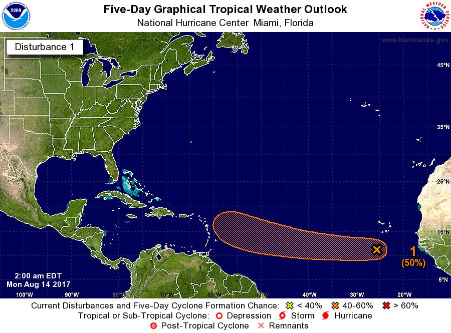
ZCZC MIATWOAT ALL
TTAA00 KNHC DDHHMM
Tropical Weather Outlook
NWS National Hurricane Center Miami FL
200 AM EDT Mon Aug 14 2017
For the North Atlantic...Caribbean Sea and the Gulf of Mexico:
The National Hurricane Center is issuing advisories on Tropical
Storm Gert, located several hundred miles west-southwest of Bermuda.
1. A large and complex area of disturbed weather to the south and
southwest of the Cabo Verde Islands is associated with a broad
trough of low pressure and a tropical wave. These systems are
forecast to merge during the next day or two, and environmental
conditions are then expected to be conducive for development of
this disturbance later this week while it moves westward at about
15 mph over the tropical Atlantic.
* Formation chance through 48 hours...low...10 percent.
* Formation chance through 5 days...medium...50 percent.
Forecaster Stewart
Member Since 2005
For official information, please refer to NHC: https://www.nhc.noaa.gov
Hurricane’s hit Puerto Rico:
San Felipe 1928, San Ciprián 1932, Santa Clara 1956, Hugo 1989, Marilyn 1995, Hortense 1996, Georges 1998, Maria 2017, Fiona 2022
Model Runs:
GFS:
[5:30 AM/PM, 11:30 AM/PM]
HWRF, GFDL, UKMET, NAVGEM:
[6:30-8:00 AM/PM, 12:30-2:00 AM/PM]
ECMWF:
[1:45 AM/PM]
For official information, please refer to NHC: https://www.nhc.noaa.gov
Hurricane’s hit Puerto Rico:
San Felipe 1928, San Ciprián 1932, Santa Clara 1956, Hugo 1989, Marilyn 1995, Hortense 1996, Georges 1998, Maria 2017, Fiona 2022
Model Runs:
GFS:
[5:30 AM/PM, 11:30 AM/PM]
HWRF, GFDL, UKMET, NAVGEM:
[6:30-8:00 AM/PM, 12:30-2:00 AM/PM]
ECMWF:
[1:45 AM/PM]
-
StormWatch
- Cat. 3
- Posts: 3721
- Joined: Thu Aug 06, 2015 11:39 am
- Location: Texas, USA
Re: INVEST 91L al SO de Cabo Verde: 10%-40%
2am #Invest91L
Up 50%
Up 50%
Member Since 2005
For official information, please refer to NHC: https://www.nhc.noaa.gov
Hurricane’s hit Puerto Rico:
San Felipe 1928, San Ciprián 1932, Santa Clara 1956, Hugo 1989, Marilyn 1995, Hortense 1996, Georges 1998, Maria 2017, Fiona 2022
Model Runs:
GFS:
[5:30 AM/PM, 11:30 AM/PM]
HWRF, GFDL, UKMET, NAVGEM:
[6:30-8:00 AM/PM, 12:30-2:00 AM/PM]
ECMWF:
[1:45 AM/PM]
For official information, please refer to NHC: https://www.nhc.noaa.gov
Hurricane’s hit Puerto Rico:
San Felipe 1928, San Ciprián 1932, Santa Clara 1956, Hugo 1989, Marilyn 1995, Hortense 1996, Georges 1998, Maria 2017, Fiona 2022
Model Runs:
GFS:
[5:30 AM/PM, 11:30 AM/PM]
HWRF, GFDL, UKMET, NAVGEM:
[6:30-8:00 AM/PM, 12:30-2:00 AM/PM]
ECMWF:
[1:45 AM/PM]