

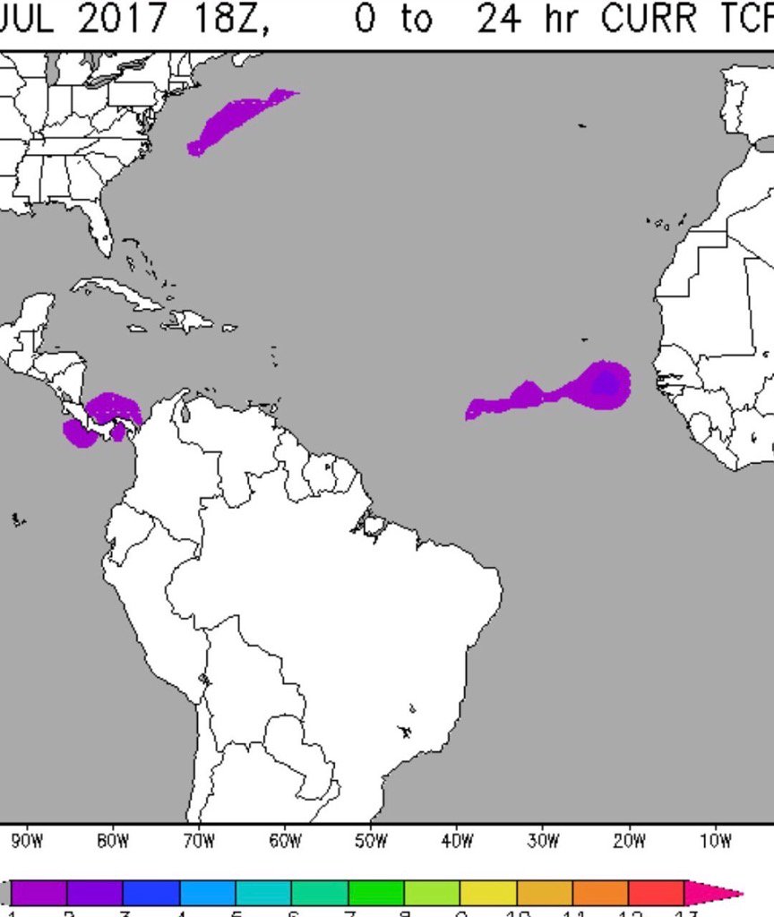
Los modelos siguen viendo desarrollo en esta zona de la ITCZ donde están estas ondas, es posible pintura amarilla.
...TROPICAL WAVES...
A tropical wave is in the E Atlc with axis extending from 15N20W
to 06N20W, moving W at 5 kt within the last 24 hours. The wave is
in a region of favorable to neutral vertical wind shear, and is
being affected by Saharan dry air and dust intrusion. Shallow moisture
confined to the vicinity of the African monsoon along with upper
level diffluence support scattered showers from 05N to 10N between
20W and 30W and isolated showers elsewhere E of 20W.
A tropical wave is in the central Atlc with axis extending from
14N30W to 03N30W, moving W at 5 kt within the last 24 hours. The
wave is in a region of favorable vertical wind shear, however it
continues to be severely affected by Saharan dry air dust, which
is limiting convection to isolated showers in the vicinity of the
monsoon trough from 04N to 09N between 30W and 39W.
Ex-Invest 97L
-
StormWatch
- Cat. 3

- Posts: 3721
- Joined: Thu Aug 06, 2015 11:39 am
- Location: Texas, USA
Re: Onda sale de África- GFS/ Euro/Cmc desarrollan
Aquí está!Alberto wrote:Los modelos siguen viendo desarrollo en esta zona de la ITCZ donde están estas ondas, es posible pintura amarilla.
...TROPICAL WAVES...
A tropical wave is in the E Atlc with axis extending from 15N20W
to 06N20W, moving W at 5 kt within the last 24 hours. The wave is
in a region of favorable to neutral vertical wind shear, and is
being affected by Saharan dry air and dust intrusion. Shallow moisture
confined to the vicinity of the African monsoon along with upper
level diffluence support scattered showers from 05N to 10N between
20W and 30W and isolated showers elsewhere E of 20W.
A tropical wave is in the central Atlc with axis extending from
14N30W to 03N30W, moving W at 5 kt within the last 24 hours. The
wave is in a region of favorable vertical wind shear, however it
continues to be severely affected by Saharan dry air dust, which
is limiting convection to isolated showers in the vicinity of the
monsoon trough from 04N to 09N between 30W and 39W.
Member Since 2005
For official information, please refer to NHC: https://www.nhc.noaa.gov
Hurricane’s hit Puerto Rico:
San Felipe 1928, San Ciprián 1932, Santa Clara 1956, Hugo 1989, Marilyn 1995, Hortense 1996, Georges 1998, Maria 2017, Fiona 2022
Model Runs:
GFS:
[5:30 AM/PM, 11:30 AM/PM]
HWRF, GFDL, UKMET, NAVGEM:
[6:30-8:00 AM/PM, 12:30-2:00 AM/PM]
ECMWF:
[1:45 AM/PM]
Re: Onda al Sur de Cabo Verde - 20%
Siii! Ya tiene un 20%
ZCZC MIATWOAT ALL
TTAA00 KNHC DDHHMM
Tropical Weather Outlook
NWS National Hurricane Center Miami FL
200 AM EDT Wed Jul 26 2017
For the North Atlantic...Caribbean Sea and the Gulf of Mexico:
1. A tropical wave, located a few hundred miles south of the Cabo Verde
Islands, is producing disorganized showers and thunderstorms. Some
slow development of this system is possible this weekend as it moves
westward at 10 to 15 mph.
* Formation chance through 48 hours...low...near 0 percent.
* Formation chance through 5 days...low...20 percent.
Forecaster Roberts
-
StormWatch
- Cat. 3
- Posts: 3721
- Joined: Thu Aug 06, 2015 11:39 am
- Location: Texas, USA
Re: Onda al Sur de Cabo Verde -10%
Aquí está la pinturitaaaa Albertopr!

Member Since 2005
For official information, please refer to NHC: https://www.nhc.noaa.gov
Hurricane’s hit Puerto Rico:
San Felipe 1928, San Ciprián 1932, Santa Clara 1956, Hugo 1989, Marilyn 1995, Hortense 1996, Georges 1998, Maria 2017, Fiona 2022
Model Runs:
GFS:
[5:30 AM/PM, 11:30 AM/PM]
HWRF, GFDL, UKMET, NAVGEM:
[6:30-8:00 AM/PM, 12:30-2:00 AM/PM]
ECMWF:
[1:45 AM/PM]
For official information, please refer to NHC: https://www.nhc.noaa.gov
Hurricane’s hit Puerto Rico:
San Felipe 1928, San Ciprián 1932, Santa Clara 1956, Hugo 1989, Marilyn 1995, Hortense 1996, Georges 1998, Maria 2017, Fiona 2022
Model Runs:
GFS:
[5:30 AM/PM, 11:30 AM/PM]
HWRF, GFDL, UKMET, NAVGEM:
[6:30-8:00 AM/PM, 12:30-2:00 AM/PM]
ECMWF:
[1:45 AM/PM]

Re: Onda al Sur de Cabo Verde - 20%
http://rammb.cira.colostate.edu/ramsdis ... display=12
Toma satelital cercana del Sur de Cabo Verde. Ahora no se ve gran cosa, así que si de ahí surgirá algo será luego de una lucha de vórtices.
pd: David79, he tratado de contactarle vía llamada y texto... ¿Será posible que me llames?
Toma satelital cercana del Sur de Cabo Verde. Ahora no se ve gran cosa, así que si de ahí surgirá algo será luego de una lucha de vórtices.
pd: David79, he tratado de contactarle vía llamada y texto... ¿Será posible que me llames?
Siempre la Madre Naturaleza es la última que ríe.
Re: Onda al Sur de Cabo Verde - 20%
Aquí el UKMET 12z... el modelo inglés insiste en cierto desarrollo a partir de las 114H. El Euro y el GFS se bajaron del bote. El CMC sigue firme en desarrollar un ciclón.

Siempre la Madre Naturaleza es la última que ríe.
-
StormWatch
- Cat. 3
- Posts: 3721
- Joined: Thu Aug 06, 2015 11:39 am
- Location: Texas, USA
Re: Onda al Sur de Cabo Verde - 20%
ZCZC MIATWOAT ALL
TTAA00 KNHC DDHHMM
Tropical Weather Outlook
NWS National Hurricane Center Miami FL
200 AM EDT Thu Jul 27 2017
For the North Atlantic...Caribbean Sea and the Gulf of Mexico:
1. A tropical wave located several hundred miles west-southwest of the
Cabo Verde Islands is producing an area of disorganized showers and
scattered thunderstorms. Some slow development is possible over the
next several days while the system moves westward or west-
northwestward at 5 to 10 mph.
* Formation chance through 48 hours...low...near 0 percent.
* Formation chance through 5 days...low...30 percent.
Forecaster Beven
Member Since 2005
For official information, please refer to NHC: https://www.nhc.noaa.gov
Hurricane’s hit Puerto Rico:
San Felipe 1928, San Ciprián 1932, Santa Clara 1956, Hugo 1989, Marilyn 1995, Hortense 1996, Georges 1998, Maria 2017, Fiona 2022
Model Runs:
GFS:
[5:30 AM/PM, 11:30 AM/PM]
HWRF, GFDL, UKMET, NAVGEM:
[6:30-8:00 AM/PM, 12:30-2:00 AM/PM]
ECMWF:
[1:45 AM/PM]
For official information, please refer to NHC: https://www.nhc.noaa.gov
Hurricane’s hit Puerto Rico:
San Felipe 1928, San Ciprián 1932, Santa Clara 1956, Hugo 1989, Marilyn 1995, Hortense 1996, Georges 1998, Maria 2017, Fiona 2022
Model Runs:
GFS:
[5:30 AM/PM, 11:30 AM/PM]
HWRF, GFDL, UKMET, NAVGEM:
[6:30-8:00 AM/PM, 12:30-2:00 AM/PM]
ECMWF:
[1:45 AM/PM]
Re: Onda al Sur de Cabo Verde - 20%
Disculpen compañer@s, problemas tecnicos causaron que el foro estuviese no disponible un par de horas durante la noche de ayer. Problema resuelto, dominio pagado!!!
Hay una actualizacion para el foro que pronto voy a instalar, sera en algun momento de noche, trataré de dejar algun aviso previo.
Saludos!
Hay una actualizacion para el foro que pronto voy a instalar, sera en algun momento de noche, trataré de dejar algun aviso previo.
Saludos!
-
StormWatch
- Cat. 3
- Posts: 3721
- Joined: Thu Aug 06, 2015 11:39 am
- Location: Texas, USA
Re: Onda al suroeste de Cabo Verde - 30%
Como q se ve algo rotando por allá abajo VERDAD??

Member Since 2005
For official information, please refer to NHC: https://www.nhc.noaa.gov
Hurricane’s hit Puerto Rico:
San Felipe 1928, San Ciprián 1932, Santa Clara 1956, Hugo 1989, Marilyn 1995, Hortense 1996, Georges 1998, Maria 2017, Fiona 2022
Model Runs:
GFS:
[5:30 AM/PM, 11:30 AM/PM]
HWRF, GFDL, UKMET, NAVGEM:
[6:30-8:00 AM/PM, 12:30-2:00 AM/PM]
ECMWF:
[1:45 AM/PM]
For official information, please refer to NHC: https://www.nhc.noaa.gov
Hurricane’s hit Puerto Rico:
San Felipe 1928, San Ciprián 1932, Santa Clara 1956, Hugo 1989, Marilyn 1995, Hortense 1996, Georges 1998, Maria 2017, Fiona 2022
Model Runs:
GFS:
[5:30 AM/PM, 11:30 AM/PM]
HWRF, GFDL, UKMET, NAVGEM:
[6:30-8:00 AM/PM, 12:30-2:00 AM/PM]
ECMWF:
[1:45 AM/PM]
