Page 8 of 10
Re: Detrás de la DT4 (GFS/Europeo agresivos)
Posted: Sun Jul 09, 2017 11:07 pm
by StormWatch
Javier wrote:Storm yo estaba pensando lo mismo del servicio eléctrico . Creo que a menos que nos den fondos federales por desastes quedarianos sin luz hasta el 2050
Jeejjee! Válgame! 2050 Súper LOL
En Texas tengo familiares q trabajan en FEMA, q por cierto se fueron de PR cuando cerraron las oficinas.
Re: Detrás de la DT4 (GFS/Europeo agresivos)
Posted: Mon Jul 10, 2017 1:07 am
by StormWatch
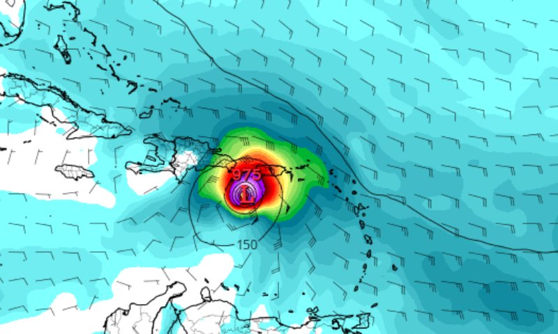
Breaking NEWS!
GFS 00z tiene un Categoría 4 cerca al sur de PR!

Muy peligrosa esa ruta, y eso sería ya para este viernes...
Re: Detrás de la DT4 (GFS/Europeo agresivos)
Posted: Mon Jul 10, 2017 1:24 am
by StormWatch
En solo 120 horas aproximadamente pudiéramos estar bajo algún aviso si se materializa este pronóstico....So.........

Re: Detrás de la DT4 (GFS/Europeo agresivos)
Posted: Mon Jul 10, 2017 1:40 am
by Arlequín
StormWatch wrote:Breaking NEWS!
GFS 00z tiene un Categoría 4 cerca al sur de PR!
Muy peligrosa esa ruta, y eso sería ya para este viernes...
Parece un Categoría 2
Re: Detrás de la DT4 (GFS/Europeo agresivos)
Posted: Mon Jul 10, 2017 1:52 am
by StormWatch
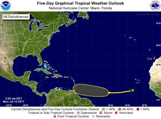
2am (0% - 20%)
ZCZC MIATWOAT ALL
TTAA00 KNHC DDHHMM
Tropical Weather Outlook
NWS National Hurricane Center Miami FL
200 AM EDT Mon Jul 10 2017
For the North Atlantic...Caribbean Sea and the Gulf of Mexico:
1. Disorganized showers and thunderstorms located several hundred
miles southwest of the Cabo Verde Islands are associated with a
tropical wave. Some gradual development is possible through the
week while this system moves westward at about 20 mph across the
tropical Atlantic Ocean.
* Formation chance through 48 hours...low...near 0 percent.
* Formation chance through 5 days...low...20 percent.
Forecaster Berg
Re: Detrás de la DT4 (GFS/Europeo agresivos)
Posted: Mon Jul 10, 2017 1:54 am
by StormWatch
2am (0% - 20%)
El cono cambio.....Hmmmmm GFS?
Re: Detrás de la DT4 (GFS/Europeo agresivos)
Posted: Mon Jul 10, 2017 7:52 am
by StormWatch
8am
Tropical Weather Outlook
NWS National Hurricane Center Miami FL
800 AM EDT Mon Jul 10 2017
For the North Atlantic...Caribbean Sea and the Gulf of Mexico:
Disorganized showers and thunderstorms located several hundred
miles southwest of the Cabo Verde Islands are associated with a
tropical wave. Some gradual development is possible through the
week while this system moves westward at about 20 mph across the
tropical Atlantic Ocean.
* Formation chance through 48 hours...low...near 0 percent.
* Formation chance through 5 days...low...20 percent.
$$
Forecaster Stewart
Re: Detrás de la DT4 (GFS/Europeo agresivos)
Posted: Mon Jul 10, 2017 8:47 am
by StormWatch
Le voy a dar 24 horas para q el GFS se retracte y pida disculpas públicas, es el único modelo q juega con los sentimientos tropicales.
Next time, le someteré una multa de $10,000 sin pena alguna!

Re: Detrás de la DT4 (GFS/Europeo agresivos)
Posted: Mon Jul 10, 2017 8:59 am
by StormWatch
Bla, bla...

Re: Detrás de la DT4 (GFS/Europeo agresivos)
Posted: Mon Jul 10, 2017 11:49 am
by StormWatch
Hola!
