
Depresión Tropical #4 en el Atlántico
-
StormWatch
- Cat. 3

- Posts: 3721
- Joined: Thu Aug 06, 2015 11:39 am
- Location: Texas, USA
Re: Invest 94L en el Atlántico este
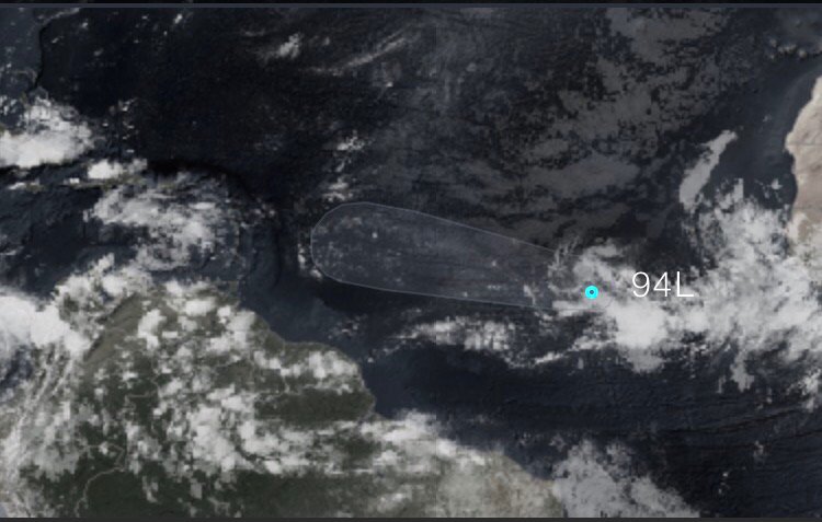
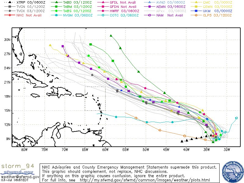
Invest 94L y la distancia hacia PR
Member Since 2005
For official information, please refer to NHC: https://www.nhc.noaa.gov
Hurricane’s hit Puerto Rico:
San Felipe 1928, San Ciprián 1932, Santa Clara 1956, Hugo 1989, Marilyn 1995, Hortense 1996, Georges 1998, Maria 2017, Fiona 2022
Model Runs:
GFS:
[5:30 AM/PM, 11:30 AM/PM]
HWRF, GFDL, UKMET, NAVGEM:
[6:30-8:00 AM/PM, 12:30-2:00 AM/PM]
ECMWF:
[1:45 AM/PM]
-
StormWatch
- Cat. 3
- Posts: 3721
- Joined: Thu Aug 06, 2015 11:39 am
- Location: Texas, USA
Re: Invest 94L en el Atlántico este
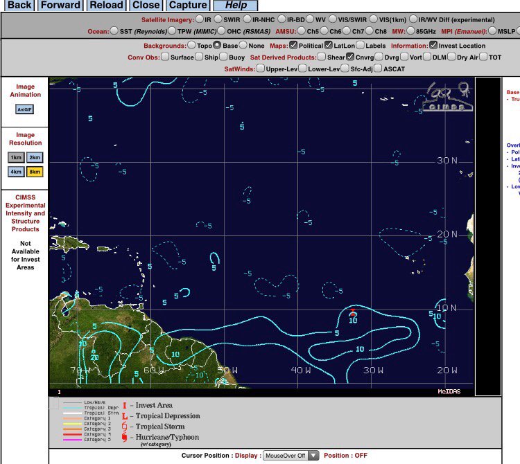
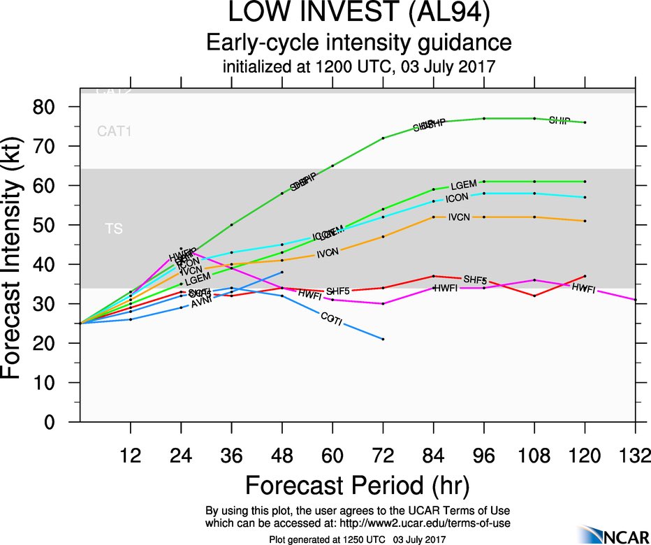
Hasta ahora los vientos cortantes no serán impedimento para fortalecerse el Invest 94L
Member Since 2005
For official information, please refer to NHC: https://www.nhc.noaa.gov
Hurricane’s hit Puerto Rico:
San Felipe 1928, San Ciprián 1932, Santa Clara 1956, Hugo 1989, Marilyn 1995, Hortense 1996, Georges 1998, Maria 2017, Fiona 2022
Model Runs:
GFS:
[5:30 AM/PM, 11:30 AM/PM]
HWRF, GFDL, UKMET, NAVGEM:
[6:30-8:00 AM/PM, 12:30-2:00 AM/PM]
ECMWF:
[1:45 AM/PM]
For official information, please refer to NHC: https://www.nhc.noaa.gov
Hurricane’s hit Puerto Rico:
San Felipe 1928, San Ciprián 1932, Santa Clara 1956, Hugo 1989, Marilyn 1995, Hortense 1996, Georges 1998, Maria 2017, Fiona 2022
Model Runs:
GFS:
[5:30 AM/PM, 11:30 AM/PM]
HWRF, GFDL, UKMET, NAVGEM:
[6:30-8:00 AM/PM, 12:30-2:00 AM/PM]
ECMWF:
[1:45 AM/PM]
-
StormWatch
- Cat. 3
- Posts: 3721
- Joined: Thu Aug 06, 2015 11:39 am
- Location: Texas, USA
Re: Invest 94L en el Atlántico este
Wepaaaaaa
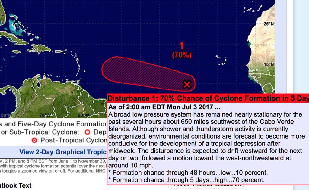
Boletín 2am 10%~70%
A broad low pressure system has remained nearly stationary for the
past several hours about 650 miles southwest of the Cabo Verde
Islands. Although shower and thunderstorm activity is currently
disorganized, environmental conditions are forecast to become more
conducive for the development of a tropical depression after
midweek. The disturbance is expected to drift westward for the next
day or two, followed a motion toward the west-northwestward at
around 10 mph.
* Formation chance through 48 hours...low...10 percent.
* Formation chance through 5 days...high...70 percent.
Member Since 2005
For official information, please refer to NHC: https://www.nhc.noaa.gov
Hurricane’s hit Puerto Rico:
San Felipe 1928, San Ciprián 1932, Santa Clara 1956, Hugo 1989, Marilyn 1995, Hortense 1996, Georges 1998, Maria 2017, Fiona 2022
Model Runs:
GFS:
[5:30 AM/PM, 11:30 AM/PM]
HWRF, GFDL, UKMET, NAVGEM:
[6:30-8:00 AM/PM, 12:30-2:00 AM/PM]
ECMWF:
[1:45 AM/PM]
For official information, please refer to NHC: https://www.nhc.noaa.gov
Hurricane’s hit Puerto Rico:
San Felipe 1928, San Ciprián 1932, Santa Clara 1956, Hugo 1989, Marilyn 1995, Hortense 1996, Georges 1998, Maria 2017, Fiona 2022
Model Runs:
GFS:
[5:30 AM/PM, 11:30 AM/PM]
HWRF, GFDL, UKMET, NAVGEM:
[6:30-8:00 AM/PM, 12:30-2:00 AM/PM]
ECMWF:
[1:45 AM/PM]
-
StormWatch
- Cat. 3
- Posts: 3721
- Joined: Thu Aug 06, 2015 11:39 am
- Location: Texas, USA
Re: Invest 94L en el Atlántico este
Invest 94L será nuestra primera amenaza?
Hmmmmmmm! Y la AEE en quiebra! So WAOOO, no se puede hablar de eso aquí!
Pero OJO con este Don!
Hmmmmmmm! Y la AEE en quiebra! So WAOOO, no se puede hablar de eso aquí!
Pero OJO con este Don!
Member Since 2005
For official information, please refer to NHC: https://www.nhc.noaa.gov
Hurricane’s hit Puerto Rico:
San Felipe 1928, San Ciprián 1932, Santa Clara 1956, Hugo 1989, Marilyn 1995, Hortense 1996, Georges 1998, Maria 2017, Fiona 2022
Model Runs:
GFS:
[5:30 AM/PM, 11:30 AM/PM]
HWRF, GFDL, UKMET, NAVGEM:
[6:30-8:00 AM/PM, 12:30-2:00 AM/PM]
ECMWF:
[1:45 AM/PM]
For official information, please refer to NHC: https://www.nhc.noaa.gov
Hurricane’s hit Puerto Rico:
San Felipe 1928, San Ciprián 1932, Santa Clara 1956, Hugo 1989, Marilyn 1995, Hortense 1996, Georges 1998, Maria 2017, Fiona 2022
Model Runs:
GFS:
[5:30 AM/PM, 11:30 AM/PM]
HWRF, GFDL, UKMET, NAVGEM:
[6:30-8:00 AM/PM, 12:30-2:00 AM/PM]
ECMWF:
[1:45 AM/PM]
-
StormWatch
- Cat. 3
- Posts: 3721
- Joined: Thu Aug 06, 2015 11:39 am
- Location: Texas, USA
Re: Invest 94L en el Atlántico este
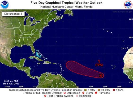
Vía Twitter página oficial del NHC:
There is a high chance of a tropical depression forming over the tropical Atlantic after midweek. See hurricanes.gov for updates.
There is a high chance of a tropical depression forming over the tropical Atlantic after midweek. See hurricanes.gov for updates.
Member Since 2005
For official information, please refer to NHC: https://www.nhc.noaa.gov
Hurricane’s hit Puerto Rico:
San Felipe 1928, San Ciprián 1932, Santa Clara 1956, Hugo 1989, Marilyn 1995, Hortense 1996, Georges 1998, Maria 2017, Fiona 2022
Model Runs:
GFS:
[5:30 AM/PM, 11:30 AM/PM]
HWRF, GFDL, UKMET, NAVGEM:
[6:30-8:00 AM/PM, 12:30-2:00 AM/PM]
ECMWF:
[1:45 AM/PM]
For official information, please refer to NHC: https://www.nhc.noaa.gov
Hurricane’s hit Puerto Rico:
San Felipe 1928, San Ciprián 1932, Santa Clara 1956, Hugo 1989, Marilyn 1995, Hortense 1996, Georges 1998, Maria 2017, Fiona 2022
Model Runs:
GFS:
[5:30 AM/PM, 11:30 AM/PM]
HWRF, GFDL, UKMET, NAVGEM:
[6:30-8:00 AM/PM, 12:30-2:00 AM/PM]
ECMWF:
[1:45 AM/PM]
-
StormWatch
- Cat. 3
- Posts: 3721
- Joined: Thu Aug 06, 2015 11:39 am
- Location: Texas, USA
Re: Invest 94L en el Atlántico este
Desde ya NEXT 
Member Since 2005
For official information, please refer to NHC: https://www.nhc.noaa.gov
Hurricane’s hit Puerto Rico:
San Felipe 1928, San Ciprián 1932, Santa Clara 1956, Hugo 1989, Marilyn 1995, Hortense 1996, Georges 1998, Maria 2017, Fiona 2022
Model Runs:
GFS:
[5:30 AM/PM, 11:30 AM/PM]
HWRF, GFDL, UKMET, NAVGEM:
[6:30-8:00 AM/PM, 12:30-2:00 AM/PM]
ECMWF:
[1:45 AM/PM]
For official information, please refer to NHC: https://www.nhc.noaa.gov
Hurricane’s hit Puerto Rico:
San Felipe 1928, San Ciprián 1932, Santa Clara 1956, Hugo 1989, Marilyn 1995, Hortense 1996, Georges 1998, Maria 2017, Fiona 2022
Model Runs:
GFS:
[5:30 AM/PM, 11:30 AM/PM]
HWRF, GFDL, UKMET, NAVGEM:
[6:30-8:00 AM/PM, 12:30-2:00 AM/PM]
ECMWF:
[1:45 AM/PM]
-
StormWatch
- Cat. 3
- Posts: 3721
- Joined: Thu Aug 06, 2015 11:39 am
- Location: Texas, USA
Re: Invest 94L en el Atlántico este
NEXT!
ZCZC MIATWOAT ALL
TTAA00 KNHC DDHHMM
Tropical Weather Outlook
NWS National Hurricane Center Miami FL
800 AM EDT Mon Jul 3 2017
For the North Atlantic...Caribbean Sea and the Gulf of Mexico:
1. A nearly stationary broad area of low pressure located about 650
miles west-southwest of the Cabo Verde Islands continues to produce
disorganized showers and thunderstorms. Environmental
conditions are expected to become more conducive for development,
and a tropical depression could form later this week. The
disturbance is expected to begin moving west-northwestward in a day
or so, and it should continue moving in that direction through the
remainder of the week.
* Formation chance through 48 hours...low...20 percent.
* Formation chance through 5 days...high...70 percent.
Forecaster Cangialosi
Member Since 2005
For official information, please refer to NHC: https://www.nhc.noaa.gov
Hurricane’s hit Puerto Rico:
San Felipe 1928, San Ciprián 1932, Santa Clara 1956, Hugo 1989, Marilyn 1995, Hortense 1996, Georges 1998, Maria 2017, Fiona 2022
Model Runs:
GFS:
[5:30 AM/PM, 11:30 AM/PM]
HWRF, GFDL, UKMET, NAVGEM:
[6:30-8:00 AM/PM, 12:30-2:00 AM/PM]
ECMWF:
[1:45 AM/PM]
For official information, please refer to NHC: https://www.nhc.noaa.gov
Hurricane’s hit Puerto Rico:
San Felipe 1928, San Ciprián 1932, Santa Clara 1956, Hugo 1989, Marilyn 1995, Hortense 1996, Georges 1998, Maria 2017, Fiona 2022
Model Runs:
GFS:
[5:30 AM/PM, 11:30 AM/PM]
HWRF, GFDL, UKMET, NAVGEM:
[6:30-8:00 AM/PM, 12:30-2:00 AM/PM]
ECMWF:
[1:45 AM/PM]

-
StormWatch
- Cat. 3
- Posts: 3721
- Joined: Thu Aug 06, 2015 11:39 am
- Location: Texas, USA
Re: Invest 94L en el Atlántico este
Parece q se va bien al NORTE! 
Member Since 2005
For official information, please refer to NHC: https://www.nhc.noaa.gov
Hurricane’s hit Puerto Rico:
San Felipe 1928, San Ciprián 1932, Santa Clara 1956, Hugo 1989, Marilyn 1995, Hortense 1996, Georges 1998, Maria 2017, Fiona 2022
Model Runs:
GFS:
[5:30 AM/PM, 11:30 AM/PM]
HWRF, GFDL, UKMET, NAVGEM:
[6:30-8:00 AM/PM, 12:30-2:00 AM/PM]
ECMWF:
[1:45 AM/PM]
For official information, please refer to NHC: https://www.nhc.noaa.gov
Hurricane’s hit Puerto Rico:
San Felipe 1928, San Ciprián 1932, Santa Clara 1956, Hugo 1989, Marilyn 1995, Hortense 1996, Georges 1998, Maria 2017, Fiona 2022
Model Runs:
GFS:
[5:30 AM/PM, 11:30 AM/PM]
HWRF, GFDL, UKMET, NAVGEM:
[6:30-8:00 AM/PM, 12:30-2:00 AM/PM]
ECMWF:
[1:45 AM/PM]
-
StormWatch
- Cat. 3
- Posts: 3721
- Joined: Thu Aug 06, 2015 11:39 am
- Location: Texas, USA
Re: Invest 94L en el Atlántico este
Hmmmmmm llegara a Huracán antes o después de las Antillas Menores??
Member Since 2005
For official information, please refer to NHC: https://www.nhc.noaa.gov
Hurricane’s hit Puerto Rico:
San Felipe 1928, San Ciprián 1932, Santa Clara 1956, Hugo 1989, Marilyn 1995, Hortense 1996, Georges 1998, Maria 2017, Fiona 2022
Model Runs:
GFS:
[5:30 AM/PM, 11:30 AM/PM]
HWRF, GFDL, UKMET, NAVGEM:
[6:30-8:00 AM/PM, 12:30-2:00 AM/PM]
ECMWF:
[1:45 AM/PM]
For official information, please refer to NHC: https://www.nhc.noaa.gov
Hurricane’s hit Puerto Rico:
San Felipe 1928, San Ciprián 1932, Santa Clara 1956, Hugo 1989, Marilyn 1995, Hortense 1996, Georges 1998, Maria 2017, Fiona 2022
Model Runs:
GFS:
[5:30 AM/PM, 11:30 AM/PM]
HWRF, GFDL, UKMET, NAVGEM:
[6:30-8:00 AM/PM, 12:30-2:00 AM/PM]
ECMWF:
[1:45 AM/PM]