
000
WTNT22 KNHC 182054
TCMAT2
POTENTIAL TROPICAL CYCLONE TWO FORECAST/ADVISORY NUMBER 1
NWS NATIONAL HURRICANE CENTER MIAMI FL AL022017
2100 UTC SUN JUN 18 2017
CHANGES IN WATCHES AND WARNINGS WITH THIS ADVISORY...
THE GOVERNMENT OF BARBADOS HAS ISSUED A TROPICAL STORM WARNING FOR
BARBADOS...ST. VINCENT...AND THE GRENADINES.
SUMMARY OF WATCHES AND WARNINGS IN EFFECT...
A TROPICAL STORM WARNING IS IN EFFECT FOR...
* BARBADOS
* ST. VINCENT AND THE GRENADINES
A TROPICAL STORM WARNING MEANS THAT TROPICAL STORM CONDITIONS ARE
EXPECTED SOMEWHERE WITHIN THE WARNING AREA WITHIN 36 HOURS.
POTENTIAL TROP CYCLONE CENTER LOCATED NEAR 7.5N 50.4W AT 18/2100Z
POSITION ACCURATE WITHIN 40 NM
PRESENT MOVEMENT TOWARD THE WEST OR 280 DEGREES AT 20 KT
ESTIMATED MINIMUM CENTRAL PRESSURE 1008 MB
MAX SUSTAINED WINDS 30 KT WITH GUSTS TO 40 KT.
WINDS AND SEAS VARY GREATLY IN EACH QUADRANT. RADII IN NAUTICAL
MILES ARE THE LARGEST RADII EXPECTED ANYWHERE IN THAT QUADRANT.
REPEAT...CENTER LOCATED NEAR 7.5N 50.4W AT 18/2100Z
AT 18/1800Z CENTER WAS LOCATED NEAR 7.3N 49.4W
FORECAST VALID 19/0600Z 8.2N 53.3W
MAX WIND 30 KT...GUSTS 40 KT.
FORECAST VALID 19/1800Z 9.5N 57.0W...TROPICAL CYCLONE
MAX WIND 35 KT...GUSTS 45 KT.
34 KT...60NE 0SE 0SW 60NW.
FORECAST VALID 20/0600Z 10.6N 60.5W
MAX WIND 45 KT...GUSTS 55 KT.
34 KT...80NE 0SE 0SW 80NW.
FORECAST VALID 20/1800Z 11.9N 64.0W
MAX WIND 40 KT...GUSTS 50 KT.
34 KT...80NE 0SE 0SW 80NW.
FORECAST VALID 21/1800Z 13.5N 71.5W...POST-TROP/REMNT LOW
MAX WIND 30 KT...GUSTS 40 KT.
EXTENDED OUTLOOK. NOTE...ERRORS FOR TRACK HAVE AVERAGED NEAR 150 NM
ON DAY 4 AND 200 NM ON DAY 5...AND FOR INTENSITY NEAR 15 KT EACH DAY
OUTLOOK VALID 22/1800Z...DISSIPATED
REQUEST FOR 3 HOURLY SHIP REPORTS WITHIN 300 MILES OF 7.5N 50.4W
NEXT ADVISORY AT 19/0300Z
$$
FORECASTER BRENNAN
Tormenta Tropical Bret al sureste de Islas de Barlovento
-
huracan_1975
- Tormenta Tropical

- Posts: 630
- Joined: Sun Aug 16, 2015 9:59 am

Re: Invest 92L (60/60) Estesureste de Islas de Barlovento
Wipiti!!! Saludos a todos, asi es la vida ciclonica un dia de los Padres velando lo que pudiera convertirse esta noche o manana en Bret, by the way felicidades a todos los padres en el Foro.
-
StormWatch
- Cat. 3

- Posts: 3721
- Joined: Thu Aug 06, 2015 11:39 am
- Location: Texas, USA
Re: Invest 92L (60/60) Estesureste de Islas de Barlovento

Member Since 2005
For official information, please refer to NHC: https://www.nhc.noaa.gov
Hurricane’s hit Puerto Rico:
San Felipe 1928, San Ciprián 1932, Santa Clara 1956, Hugo 1989, Marilyn 1995, Hortense 1996, Georges 1998, Maria 2017, Fiona 2022
Model Runs:
GFS:
[5:30 AM/PM, 11:30 AM/PM]
HWRF, GFDL, UKMET, NAVGEM:
[6:30-8:00 AM/PM, 12:30-2:00 AM/PM]
ECMWF:
[1:45 AM/PM]

Re: Invest 92L (60/60) Estesureste de Islas de Barlovento
Podre darme el lujo de decir que fui testigo de ver la primera tormenta al este de las Antillas en el mes de Junio 


Re: Invest 92L (60/60) Estesureste de Islas de Barlovento
En Spanish
BOLETIN
POTENCIAL DE CICLON TROPICAL DOS ADVERTENCIA NUMERO 1
CENTRO NACIONAL DE HURACANES MIAMI FL AL022017
TRADUCIDO POR EL SERVICIO NACIONAL DE METEOROLOGIA SAN JUAN PR
500 PM AST DOMINGO 18 DE JUNIO DE 2017
...AVISO DE TORMENTA TROPICAL EMITIDA PARA PORCIONES DE LAS ISLAS
DE BARLOVENTO...
RESUMEN DE LA INFORMACION DE LAS 500 PM AST...2100 UTC
------------------------------------------------------
LOCALIZACION...7.5 NORTE 50.4 OESTE
ALREDEDOR DE 815 MI...1310 KM AL ESTE SURESTE DE LAS ISLAS DE
BARLOVENTO
VIENTOS MAXIMOS SOSTENIDOS...35 MPH...55 KM/H
MOVIMIENTO ACTUAL...OESTE O 280 GRADOS A 23 MPH...37 KM/H
PRESION MINIMA CENTRAL...1008 MB...29.77 PULGADAS
VIGILANCIAS Y AVISOS
--------------------
CAMBIOS CON ESTA ADVERTENCIA:
El gobierno de Barbados ha emitido un Aviso de Tormenta Tropical para
Barbados, San Vicente y las Granadinas.
RESUMEN DE VIGILANCIA O AVISOS EN EFECTO:
Un Aviso de Tromenta Tropical esta en efecto para...
* Barbados
* San Vicente y las Granadinas
Un Aviso de Tormenta Tropical significa que se esperan condiciones
de tormenta tropical dentro del area bajo aviso dentro de 36 horas.
Para informacion especifica para su area, favor estar atentos a los
productos emitidos por el Servicio Meteorologico Nacional.
DISCUSION Y PRONOSTICO DE 48 HORAS
----------------------------------
A las 500 PM AST (2100 UTC), el disturbio estaba centralizado cerca
de la latitude 7.5 norte, longitud 50.4 oeste. Este sistema se mueve
hacia el oeste a cerca de 23 mph (37 km/h). Un movimiento rapido
hacia el oeste noreste se espera continue durante las proximas 48
horas. En la trayectoria pronosticada, se espera que el disturbio se
mueva a traves de las Islas de Barlovento el lunes en la noche y
martes.
Los vientos maximos sostenidos estan cerca de 35 mph (55 km/h) con
rafagas mas altas. Se pronostica algun fortalecimiento durante las
proximas 48 horas y se espera que el disturbio alcance intensidad
de tormenta tropical el lunes antes de llegar a las Islas de
Barlovneto.
La actividad de aguaceros y tronadas asociada con el disturbio esta
mejor organizada desde ayer, algun desarrollo adicional es posible
durante los proximos dias antes de que las condiciones se tornen
menos favorables para desarrollo de ciclon tropical sobre el Mar
Caribe.
* Probabilidad de formacion en 48 horas...alta...70 por ciento.
* Probabilidad de formacion en 5 dias...alta...70 por ciento.
La presion central minima estimada es 1008 mb (29.77 pulgadas).
PELIGROS AFECTANDO TIERRA
-------------------------
VIENTO: Condiciones de Tormenta Tropical se anticipa primero
alcancen el area bajo aviso lunes en la noche y martes en la
manana, haciendo los preparativos externos dificil o peligrosos.
LLUVIA: Se espera que el disturbio produzca acumulacion total de
lluvia entre 2 y 4 pulgadas sobre las Islas de Barlovento entre
el lunes y martes.
LA PROXIMA ADVERTENCIA
----------------------
Proxima advertencia intermedia a las 800 PM AST.
Proxima advertencia completa a las 1100 PM AST.
$$
Pronosticador Brennan
ACotto
emh- huracan es simplemente ahora Edgardo. Importante: Phil Klotzbach, recordó que "el mejor momento para prepararse para los huracanes es cuando todavía no hay huracanes".
Re: Invest 92L (60/60) Estesureste de Islas de Barlovento
Felicidades Villafane y a todos los padres de este foro. Que buen comienzo de la nueva temporada de huracanes 2017.Villafañe wrote:Wipiti!!! Saludos a todos, asi es la vida ciclonica un dia de los Padres velando lo que pudiera convertirse esta noche o manana en Bret, by the way felicidades a todos los padres en el Foro.
emh- huracan es simplemente ahora Edgardo. Importante: Phil Klotzbach, recordó que "el mejor momento para prepararse para los huracanes es cuando todavía no hay huracanes".
-
StormWatch
- Cat. 3
- Posts: 3721
- Joined: Thu Aug 06, 2015 11:39 am
- Location: Texas, USA
Re: Invest 92L (60/60) Estesureste de Islas de Barlovento
Vía Twitter @CycloforumsPR
En su boletín 8pm, el Centro Nacional Huracanes indica que el sistema de potencial ciclónico #2 tiene 90% de posibilidad de desarrollarse.
En su boletín 8pm, el Centro Nacional Huracanes indica que el sistema de potencial ciclónico #2 tiene 90% de posibilidad de desarrollarse.
Member Since 2005
For official information, please refer to NHC: https://www.nhc.noaa.gov
Hurricane’s hit Puerto Rico:
San Felipe 1928, San Ciprián 1932, Santa Clara 1956, Hugo 1989, Marilyn 1995, Hortense 1996, Georges 1998, Maria 2017, Fiona 2022
Model Runs:
GFS:
[5:30 AM/PM, 11:30 AM/PM]
HWRF, GFDL, UKMET, NAVGEM:
[6:30-8:00 AM/PM, 12:30-2:00 AM/PM]
ECMWF:
[1:45 AM/PM]
For official information, please refer to NHC: https://www.nhc.noaa.gov
Hurricane’s hit Puerto Rico:
San Felipe 1928, San Ciprián 1932, Santa Clara 1956, Hugo 1989, Marilyn 1995, Hortense 1996, Georges 1998, Maria 2017, Fiona 2022
Model Runs:
GFS:
[5:30 AM/PM, 11:30 AM/PM]
HWRF, GFDL, UKMET, NAVGEM:
[6:30-8:00 AM/PM, 12:30-2:00 AM/PM]
ECMWF:
[1:45 AM/PM]
Re: Invest 92L (60/60) Estesureste de Islas de Barlovento
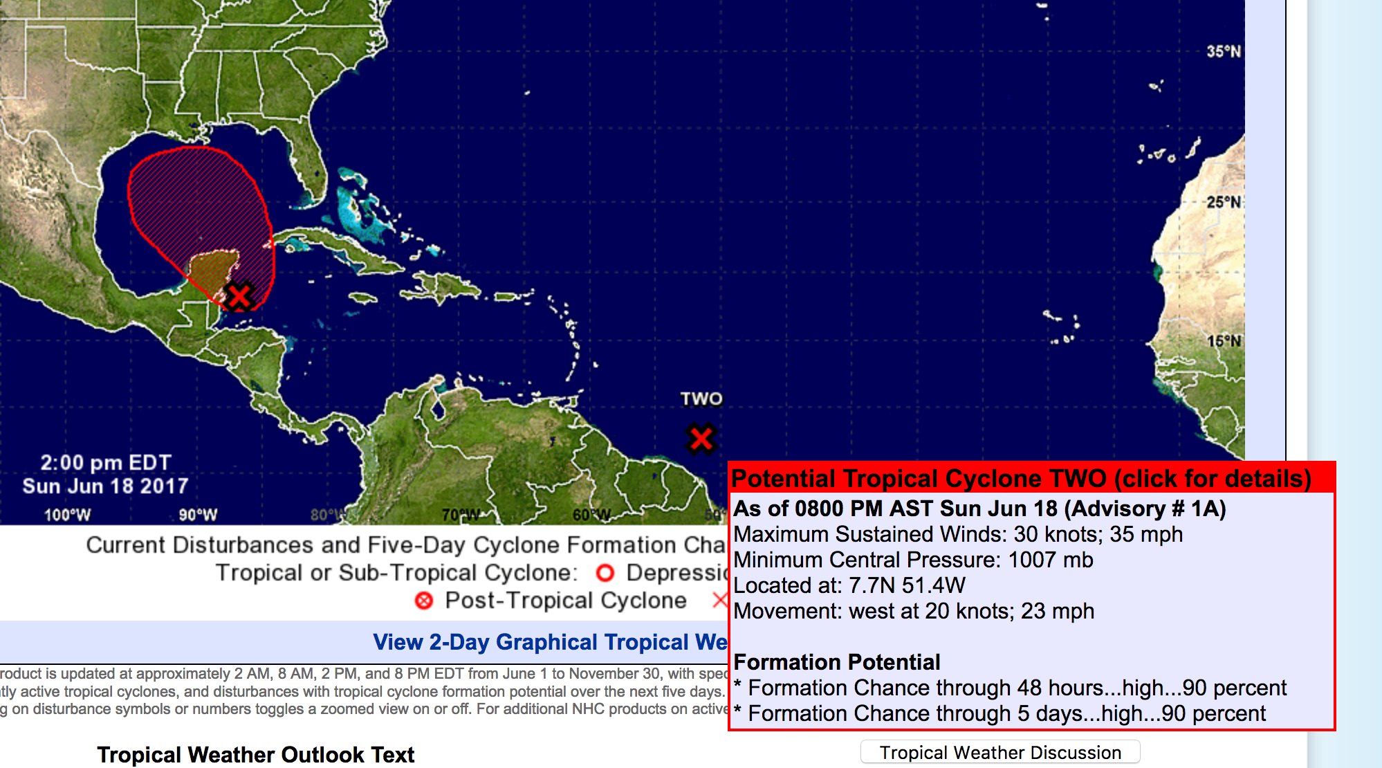
Tropical Weather Outlook
NWS National Hurricane Center Miami FL
800 PM EDT Sun Jun 18 2017
For the North Atlantic...Caribbean Sea and the Gulf of Mexico:
The National Hurricane Center is issuing advisories on Potential
Tropical Cyclone Two, located several hundred miles east-southeast
of the southern Windward Islands.
* Formation chance through 48 hours...high...90 percent.
* Formation chance through 5 days...high...90 percent.
A broad area of low pressure located near the east coast of the
Yucatan Peninsula continues to produce a large area of disorganized
showers and thunderstorms along with winds to gale force several
hundred miles to the east and northeast of the center. Although
surface pressures are falling over the northwestern Caribbean Sea,
the low still lacks a well-defined center of circulation. However,
gradual development of this system is expected while it moves
slowly north-northwestward across the Yucatan Peninsula overnight,
and then over the southern or central Gulf of Mexico on Monday and
Tuesday, where a tropical or subtropical cyclone is likely to form.
Regardless of development, heavy rains are expected to continue over
portions of Central America, the Yucatan Peninsula, Jamaica, the
Cayman Islands, and western Cuba during the next few days. An Air
Force Reserve Hurricane Hunter aircraft is scheduled to investigate
this system on Monday, if necessary. For more information on this
system, please see the High Seas Forecast issued by the Tropical
Analysis and Forecast Branch.
* Formation chance through 48 hours...high...80 percent.
* Formation chance through 5 days...high...90 percent.
emh- huracan es simplemente ahora Edgardo. Importante: Phil Klotzbach, recordó que "el mejor momento para prepararse para los huracanes es cuando todavía no hay huracanes".
Re: Invest 92L (60/60) Estesureste de Islas de Barlovento
BOLETIN
POTENCIAL DE CICLON TROPICAL DOS ADVERTENCIA INTERMEDIA NUMERO 1A
CENTRO NACIONAL DE HURACANES MIAMI FL AL022017
TRADUCIDO POR EL SERVICIO NACIONAL DE METEOROLOGIA SAN JUAN PR
800 PM AST DOMINGO 18 DE JUNIO DE 2017
...AVISO DE TORMENTA TROPICAL EMITIDA PARA PORCIONES DEL SUR DE
LAS ISLAS DE BARLOVENTO...
RESUMEN DE LA INFORMACION DE LAS 800 PM AST...0000 UTC
------------------------------------------------------
LOCALIZACION...7.7 NORTE 51.4 OESTE
ALREDEDOR DE 690 MI...1110 KM AL ESTE SURESTE DE LAS ISLAS DE
BARLOVENTO
VIENTOS MAXIMOS SOSTENIDOS...35 MPH...55 KM/H
MOVIMIENTO ACTUAL...OESTE O 280 GRADOS A 23 MPH...37 KM/H
PRESION MINIMA CENTRAL...1007 MB...29.74 PULGADAS
VIGILANCIAS Y AVISOS
--------------------
CAMBIOS CON ESTA ADVERTENCIA:
El gobierno de Trinidad y Tobago ha emitido un Aviso de Tormenta
Tropical para Trinidad, Tobago y Grenada.
RESUMEN DE VIGILANCIA O AVISOS EN EFECTO:
Un Aviso de Tromenta Tropical esta en efecto para...
* Barbados
* San Vicente y las Granadinas
* Trinidad
* Tobago
* Grenada
Un Aviso de Tormenta Tropical significa que se esperan condiciones
de tormenta tropical dentro del area bajo aviso dentro de 36 horas.
Para informacion especifica para su area, favor estar atentos a los
productos emitidos por el Servicio Meteorologico Nacional.
DISCUSION Y PRONOSTICO DE 48 HORAS
----------------------------------
A las 800 PM AST (0000 UTC), el disturbio estaba centralizado cerca
de la latitude 7.7 norte, longitud 51.4 oeste. Este sistema se
mueve hacia el oeste a cerca de 23 mph (37 km/h). Un movimiento
rapido hacia el oeste noreste se espera durante las proximas 48
horas. En la trayectoria pronosticada, se espera que el disturbio
se mueva a traves de las Islas de Barlovento el lunes en la noche y
martes.
Los vientos maximos sostenidos estan cerca de 35 mph (55 km/h) con
rafagas mas altas. Se pronostica algun fortalecimiento durante las
proximas 48 horas y se espera que el disturbio alcance intensidad
de tormenta tropical esta noche o el lunes antes de llegar a las
Islas de Barlovneto.
La actividad de aguaceros y tronadas asociada con el disturbio se
esta tornando mas organizada, y desarrollo adicional es probable
durante los proximos dias.
* Probabilidad de formacion en 48 horas...alta...90 por ciento.
* Probabilidad de formacion en 5 dias...alta...90 por ciento.
La presion central minima estimada es 1007 mb (29.74 pulgadas).
PELIGROS AFECTANDO TIERRA
-------------------------
VIENTO: Condiciones de Tormenta Tropical se anticipa primero
alcancen el area bajo aviso lunes en la noche y martes en la
manana, haciendo los preparativos externos dificil o peligrosos.
LLUVIA: Se espera que el disturbio produzca acumulacion total de
lluvia entre 2 y 4 pulgadas sobre las Islas de Barlovento entre
el lunes y martes.
LA PROXIMA ADVERTENCIA
----------------------
Proxima advertencia completa a las 1100 PM AST.
$$
Pronosticador Stewart/Cangialosi
ACotto
emh- huracan es simplemente ahora Edgardo. Importante: Phil Klotzbach, recordó que "el mejor momento para prepararse para los huracanes es cuando todavía no hay huracanes".

Re: Invest 92L (60/60) Estesureste de Islas de Barlovento
000
WTNT32 KNHC 190240
TCPAT2
BULLETIN
Potential Tropical Cyclone Two Advisory Number 2
NWS National Hurricane Center Miami FL AL022017
1100 PM AST Sun Jun 18 2017
...TROPICAL STORM CONDITIONS EXPECTED TO REACH THE SOUTHERN WINDWARD
ISLANDS BY MONDAY NIGHT...
SUMMARY OF 1100 PM AST...0300 UTC...INFORMATION
-----------------------------------------------
LOCATION...7.9N 52.4W
ABOUT 630 MI...1015 KM ESE OF TRINIDAD
ABOUT 695 MI...1120 KM ESE OF GRENADA
MAXIMUM SUSTAINED WINDS...40 MPH...65 KM/H
PRESENT MOVEMENT...W OR 280 DEGREES AT 23 MPH...37 KM/H
MINIMUM CENTRAL PRESSURE...1005 MB...29.68 INCHES
WATCHES AND WARNINGS
--------------------
CHANGES WITH THIS ADVISORY:
None.
SUMMARY OF WATCHES AND WARNINGS IN EFFECT:
A Tropical Storm Warning is in effect for...
* Barbados
* St. Vincent and the Grenadines
* Trinidad
* Tobago
* Grenada
A Tropical Storm Warning means that tropical storm conditions are
expected somewhere within the warning area within 36 hours.
For storm information specific to your area, please monitor
products issued by your national meteorological service.
DISCUSSION AND 48-HOUR OUTLOOK
------------------------------
At 1100 PM AST (0300 UTC), the disturbance was centered near
latitude 7.9 North, longitude 52.4 West. A fast motion toward the
west-northwest is expected for the next 48 hours. On the forecast
track, the disturbance is expected to move through the Windward
Islands Monday night and Tuesday.
Maximum sustained winds have increased to near 40 mph (65 km/h) with
higher gusts. Some additional strengthening is expected during the
next 48 hours, and the disturbance is forecast to be a tropical
storm when it moves through the Windward Islands Monday night and
Tuesday.
Thunderstorm activity associated with the disturbance continues to
become better organized, and additional development is likely during
the next day or two.
* Formation chance through 48 hours...high...90 percent
* Formation chance through 5 days...high...90 percent
Tropical-storm-force winds extend outward up to 60 miles (95 km),
mainly northwest through northeast of the center.
The estimated minimum central pressure is 1005 mb (29.68 inches).
HAZARDS AFFECTING LAND
----------------------
WIND: Tropical storm conditions are expected to first reach the
warning area overnight Monday and Tuesday morning, making outside
preparations difficult or dangerous.
RAINFALL: The disturbance is expected to produce total rain
accumulations of 2 to 4 inches over the Windward Islands Monday
night and Tuesday.
NEXT ADVISORY
-------------
Next intermediate advisory at 200 AM AST.
Next complete advisory at 500 AM AST.
$$
Forecaster Stewart