
Huracan Cat 4 Nicole hacia Bermuda

Huracan Cat 4 Nicole hacia Bermuda
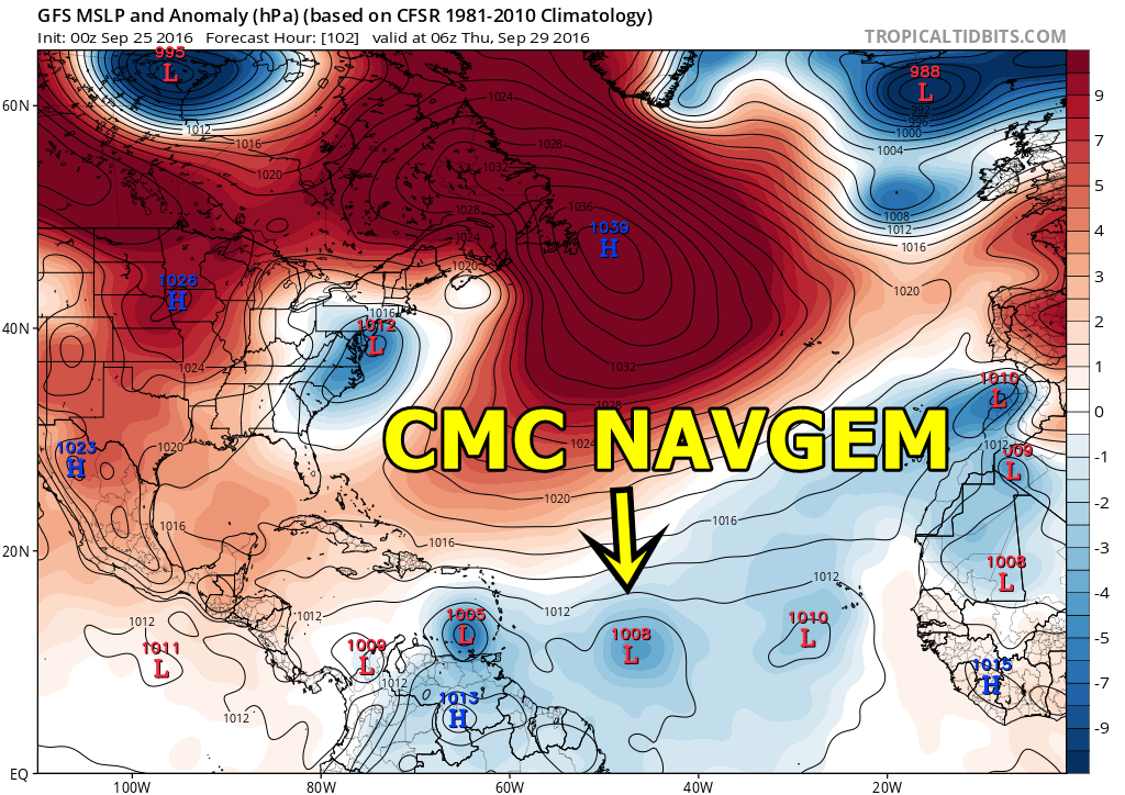
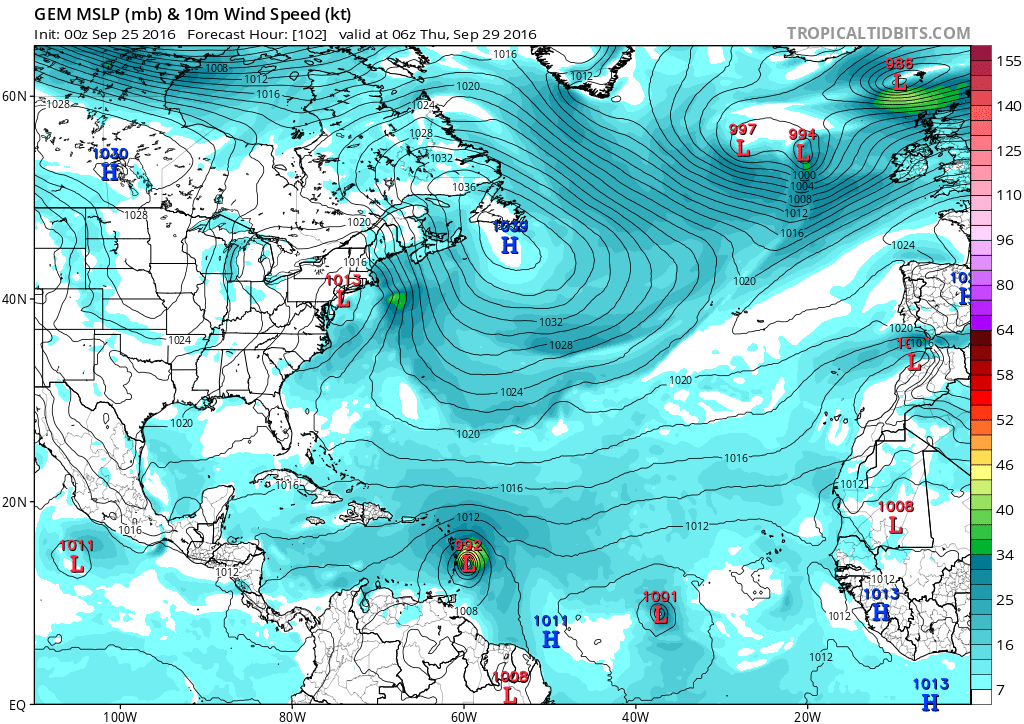
El GFS insiste en formar otro sistema detrás del P 43L (Matthew) que vigilamos. Hay otros modelos como el CMC y Navgem que tiene un sistema para el 1 de octubre... por si acaso, le abro este topic.
Last edited by Alberto on Thu Oct 06, 2016 7:59 pm, edited 2 times in total.
Re: GFS forma otro sistema detrás del P43L
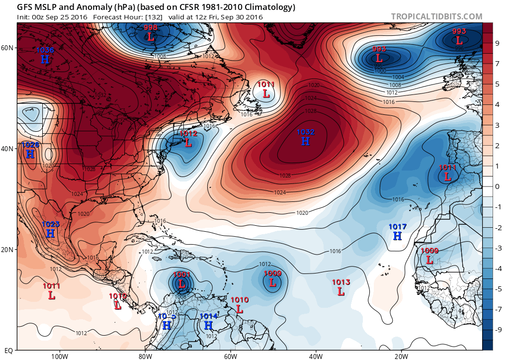
Me pregunto, será entonces ese otro sistema el que ve Navgem y CMC para el 1 de octubre??

Re: GFS forma otro sistema detrás del P43L
Saludos Alberto así es sobre todo el CMC que desarrolla más agresivo a este sistema que continuaremos monitoreando
Re: GFS forma otro sistema detrás del P43L
Muy complicado el asunto, la verdad que no lo compro mucho.. eso de separar los dos sistemas
-
huracan sur
- Depresión Tropical

- Posts: 400
- Joined: Wed Sep 04, 2013 3:26 am
Re: GFS forma otro sistema detrás del P43L
Digo presente también aquí a observar todo lo que se acerque al Caribe
Para información oficial favor referirse a las agencias pertinentes. Un aficionado a la meteorología #TeamCycloforums
Re: GFS forma otro sistema detrás del P43L
Se ganó su pintura amarilla
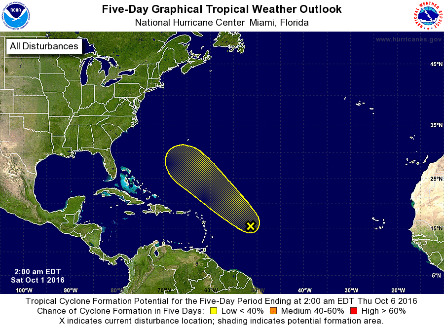

Re: Onda al Este de las Antillas 10/20%
TROPICAL WEATHER OUTLOOK
NWS NATIONAL HURRICANE CENTER MIAMI FL
200 AM EDT SAT OCT 1 2016
For the North Atlantic...Caribbean Sea and the Gulf of Mexico:
The National Hurricane Center is issuing advisories on Hurricane
Matthew, located over the south-central Caribbean Sea.
1. A weak area of low pressure, associated with a tropical wave, is
producing disorganized showers and thunderstorms over the central
tropical Atlantic well east of the Lesser Antilles. Although recent
satellite wind data indicate that the system is producing winds just
below tropical storm force, any additional development is expected
to be slow to occur due to strong upper-level winds while the low
moves northwestward at 15 mph.
* Formation chance through 48 hours...low...10 percent
* Formation chance through 5 days...low...20 percent
Siempre la Madre Naturaleza es la última que ríe.
-
StormWatch
- Cat. 3

- Posts: 3721
- Joined: Thu Aug 06, 2015 11:39 am
- Location: Texas, USA
Re: Onda al Este de las Antillas 10/20%
Up 20% - 30%
ZCZC MIATWOAT ALL
TTAA00 KNHC DDHHMM
TROPICAL WEATHER OUTLOOK
NWS NATIONAL HURRICANE CENTER MIAMI FL
200 AM EDT SUN OCT 2 2016
For the North Atlantic...Caribbean Sea and the Gulf of Mexico:
The National Hurricane Center is issuing advisories on Hurricane
Matthew, located over the central Caribbean Sea.
1. Showers and thunderstorms have become a little better organized
near a broad area of low pressure located about 600 miles
east-northeast of the Leeward Islands. The low has moved into an
area where upper-level winds could be a little more conducive for
development during the next day or two, but these winds are
expected to become unfavorable again by the middle of the week.
Therefore, significant development of the low is still expected to
be slow to occur while it moves west-northwestward or northwestward
at 15 mph.
* Formation chance through 48 hours...low...20 percent
* Formation chance through 5 days...low...30 percent
Forecaster Berg
Member Since 2005
For official information, please refer to NHC: https://www.nhc.noaa.gov
Hurricane’s hit Puerto Rico:
San Felipe 1928, San Ciprián 1932, Santa Clara 1956, Hugo 1989, Marilyn 1995, Hortense 1996, Georges 1998, Maria 2017, Fiona 2022
Model Runs:
GFS:
[5:30 AM/PM, 11:30 AM/PM]
HWRF, GFDL, UKMET, NAVGEM:
[6:30-8:00 AM/PM, 12:30-2:00 AM/PM]
ECMWF:
[1:45 AM/PM]
-
StormWatch
- Cat. 3
- Posts: 3721
- Joined: Thu Aug 06, 2015 11:39 am
- Location: Texas, USA
Re: Onda al Este de las Antillas 10/20%

Member Since 2005
For official information, please refer to NHC: https://www.nhc.noaa.gov
Hurricane’s hit Puerto Rico:
San Felipe 1928, San Ciprián 1932, Santa Clara 1956, Hugo 1989, Marilyn 1995, Hortense 1996, Georges 1998, Maria 2017, Fiona 2022
Model Runs:
GFS:
[5:30 AM/PM, 11:30 AM/PM]
HWRF, GFDL, UKMET, NAVGEM:
[6:30-8:00 AM/PM, 12:30-2:00 AM/PM]
ECMWF:
[1:45 AM/PM]
For official information, please refer to NHC: https://www.nhc.noaa.gov
Hurricane’s hit Puerto Rico:
San Felipe 1928, San Ciprián 1932, Santa Clara 1956, Hugo 1989, Marilyn 1995, Hortense 1996, Georges 1998, Maria 2017, Fiona 2022
Model Runs:
GFS:
[5:30 AM/PM, 11:30 AM/PM]
HWRF, GFDL, UKMET, NAVGEM:
[6:30-8:00 AM/PM, 12:30-2:00 AM/PM]
ECMWF:
[1:45 AM/PM]