

Huracán Matthew
-
StormWatch
- Cat. 3

- Posts: 3721
- Joined: Thu Aug 06, 2015 11:39 am
- Location: Texas, USA
Re: Huracán Matthew
Matthew and Nicole
Member Since 2005
For official information, please refer to NHC: https://www.nhc.noaa.gov
Hurricane’s hit Puerto Rico:
San Felipe 1928, San Ciprián 1932, Santa Clara 1956, Hugo 1989, Marilyn 1995, Hortense 1996, Georges 1998, Maria 2017, Fiona 2022
Model Runs:
GFS:
[5:30 AM/PM, 11:30 AM/PM]
HWRF, GFDL, UKMET, NAVGEM:
[6:30-8:00 AM/PM, 12:30-2:00 AM/PM]
ECMWF:
[1:45 AM/PM]

Re: Huracán Matthew
A lo lejos, tengo la impresion que, de momento, el evento catastrofico que se temia con el paso de Matthew no sera tan severo.
Despues de todo, el grueso de los centros de mas densa poblacion, como la capital y la region de Gonaives y Cape Haitien han permanecido lejos del paso del ojo y aunque siempre mata gente el exceso de lluvia, no es lo mismo movilizarse y buscar refugio bajo vientos de tormenta tropical que teniendo encima vientos de mas de 120mph__La mayor parte del territorio ha permanecido al margen de los vientos catastroficos del sistema.
Los centros de poblacion mas cercanos al ojo parecen haber sido la ciudad de Les Cayes, de cuyo centro el ciclon paso unas cuantas millas el oestee y Jeremie, (cuya imagen pusimos mas arriba y que es donde parece haber pasado el ojo de Matthew.
Esperando que los reportes no indiquen lo contrario y que las lluvias esta vez no repitan la historia de desgracias pasadas, seguimos deseandoles lo mejor a nuestros hermanos haitianos en esta hora de adversidad.
Re: Huracán Matthew
BULLETIN
HURRICANE MATTHEW INTERMEDIATE ADVISORY NUMBER 26A
NWS NATIONAL HURRICANE CENTER MIAMI FL AL142016
200 PM EDT TUE OCT 04 2016
...EYE OF EXTREMELY DANGEROUS HURRICANE MATTHEW EXPECTED TO HIT
FAR EASTERN CUBA HARD LATER TODAY...
SUMMARY OF 200 PM EDT...1800 UTC...INFORMATION
----------------------------------------------
LOCATION...19.4N 74.3W
ABOUT 65 MI...105 KM ESE OF GUANTANAMO CUBA
ABOUT 55 MI...90 KM SSW OF THE EASTERN TIP OF CUBA
MAXIMUM SUSTAINED WINDS...145 MPH...230 KM/H
PRESENT MOVEMENT...N OR 360 DEGREES AT 10 MPH...17 KM/H
MINIMUM CENTRAL PRESSURE...949 MB...28.02 INCHES
WATCHES AND WARNINGS
--------------------
CHANGES WITH THIS ADVISORY:
None.
SUMMARY OF WATCHES AND WARNINGS IN EFFECT:
A Hurricane Warning is in effect for...
* Haiti
* Cuban provinces of Guantanamo, Santiago de Cuba, Holguin, Granma,
and Las Tunas
* Southeastern Bahamas, including the Inaguas, Mayaguana, Acklins,
Crooked Island, Long Cay, and Ragged Island
* Central Bahamas, including Long Island, Exuma, Rum Cay,
San Salvador, and Cat Island
* Northwestern Bahamas, including the Abacos, Andros Island,
Berry Islands, Bimini, Eleuthera, Grand Bahama Island, and
New Providence
A Hurricane Watch is in effect for...
* Cuban province of Camaguey
* Deerfield Beach to the Volusia/Brevard county line
A Tropical Storm Warning is in effect for...
* Dominican Republic from Barahona westward to the border with Haiti
* Turks and Caicos Islands
A Tropical Storm Watch is in effect for...
* Dominican Republic from Puerto Plata westward to the border with
Haiti
* Seven Mile Bridge to south of Deerfield Beach
* Lake Okeechobee
A Hurricane Watch means that hurricane conditions are possible
within the watch area. A watch is typically issued 48 hours before
the anticipated first occurrence of tropical-storm-force winds,
conditions that make outside preparations difficult or dangerous.
A Tropical Storm Watch means that tropical storm conditions are
possible within the watch area, generally within 48 hours.
Interests elsewhere in Hispaniola and in the Florida Peninsula and
the Florida Keys should monitor the progress of Matthew.
For storm information specific to your area in the United States,
including possible inland watches and warnings, please monitor
products issued by your local National Weather Service forecast
office. For storm information specific to your area outside
the United States, please monitor products issued by your national
meteorological service.
DISCUSSION AND 48-HOUR OUTLOOK
------------------------------
At 200 PM EDT (1800 UTC), the eye of Hurricane Matthew was located
in the Windward Passage near latitude 19.4 North, longitude 74.3
West. Matthew is moving toward the north near 10 mph (17 km/h). On
this track the eye of Matthew will move over the extreme portion of
eastern Cuba later this afternoon. A turn toward the north-
northwest is expected by Wednesday, followed by a northwest turn
Wednesday night. Matthew is expected to move near or over portions
of the southeastern and central Bahamas tonight and Wednesday, and
approach the northwestern Bahamas Wednesday night.
Maximum sustained winds remain near 145 mph (230 km/h) with higher
gusts. Matthew is a category 4 hurricane on the Saffir- Simpson
Hurricane Wind Scale. Some fluctuations in intensity are possible
during the next couple of days, but Matthew is expected to remain a
powerful hurricane through at least Wednesday night.
Hurricane-force winds extend outward up to 60 miles (95 km) from
the center and tropical-storm-force winds extend outward up to 185
miles (295 km). Data from the Cuban Meteorological Institute
indicate that winds of tropical storm force are already affecting
portions of eastern Cuba.
The minimum central pressure recently reported by an Air Force
reconnaissance plane was 949 mb (28.02 inches).
HAZARDS AFFECTING LAND
----------------------
WIND: Hurricane conditions are still affecting portions of
Haiti. Hurricane conditions are expected to reach eastern Cuba later
today, the southeastern Bahamas this evening, the central Bahamas
on Wednesday, and the northwestern Bahamas Wednesday night.
Tropical storm conditions are expected to continue spreading across
the remainder of Haiti today, eastern Cuba and the southeastern
Bahamas later today, and the central and northwestern Bahamas
Tuesday night and Wednesday, making outside preparations difficult
or dangerous.
Tropical storm conditions are still occurring in portions the
Dominican Republic within the warning area, and these conditions
will spread northward into the Turks and Caicos Islands tonight.
Hurricane conditions are possible in the hurricane watch areas in
Cuba tonight with tropical storm conditions possible later today.
Hurricane conditions are possible within the hurricane watch
area in Florida by late Thursday, with tropical storm conditions
possible by early Thursday. Tropical storm condition are also
possible in the Florida tropical storm watch area by early Thursday.
RAINFALL: Matthew is expected to produce total rainfall amounts in
the following areas:
Southern Haiti and southwestern Dominican Republic...15 to 25
inches, isolated 40 inches
Eastern Cuba and northwestern Haiti...8 to 12 inches, isolated
20 inches
Eastern Jamaica...4 to 6 inches, isolated 10 inches
The Bahamas...8 to 12 inches, isolated 15 inches
Turks and Caicos Islands...2 to 5 inches, isolated 8 inches
Northeastern Haiti and the Northern Dominican Republic...1 to 3
inches, isolated 5 inches
Western Jamaica...1 to 2 inches, isolated 3 inches
Upper Florida Keys northward to coastal east-central Florida....4 to
7 inches, isolated 10 inches
Middle to Lower Florida Keys....1 to 3 inches, isolated 5 inches
Life-threatening flash floods and mudslides are likely from this
rainfall in southern and northwestern Haiti, the southwestern
Dominican Republic, and eastern Cuba.
STORM SURGE: The combination of a dangerous storm surge and large
and destructive waves could raise water levels by as much as the
following amounts above normal tide levels...
Southern Coast of Cuba east of Cabo Cruz...7 to 11 feet
South Coast of Haiti...7 to 10 feet
Northern Coast of Cuba east of Camaguey...4 to 6 feet
Jamaica...2 to 4 feet
Gulf of Gonave in Haiti...3 to 5 feet
Southern coast of the Dominican Republic...1 to 3 feet
The Bahamas...10 to 15 feet
Surge-related flooding depends on the relative timing of the surge
and the tidal cycle, and can vary greatly over short distances.
Large waves generated by Matthew will cause water rises to occur
well in advance of and well away from the track of the center.
SURF: Swells generated by Matthew will continue to affect portions
of the coasts of Hispaniola, Jamaica, eastern Cuba, and the
Caribbean coastline of Central America during the next few
days. Swells from Matthew will begin affecting portions of the
Bahamas on Tuesday. These swells are likely to cause life-
threatening surf and rip current conditions. Please consult
products from your local weather office.
NEXT ADVISORY
-------------
Next complete advisory at 500 PM EDT.
$$
Forecaster Avila
emh- huracan es simplemente ahora Edgardo. Importante: Phil Klotzbach, recordó que "el mejor momento para prepararse para los huracanes es cuando todavía no hay huracanes".
-
StormWatch
- Cat. 3
- Posts: 3721
- Joined: Thu Aug 06, 2015 11:39 am
- Location: Texas, USA
Re: Huracán Matthew
Huracan Matthew en ruta a Cuba!

Member Since 2005
For official information, please refer to NHC: https://www.nhc.noaa.gov
Hurricane’s hit Puerto Rico:
San Felipe 1928, San Ciprián 1932, Santa Clara 1956, Hugo 1989, Marilyn 1995, Hortense 1996, Georges 1998, Maria 2017, Fiona 2022
Model Runs:
GFS:
[5:30 AM/PM, 11:30 AM/PM]
HWRF, GFDL, UKMET, NAVGEM:
[6:30-8:00 AM/PM, 12:30-2:00 AM/PM]
ECMWF:
[1:45 AM/PM]
For official information, please refer to NHC: https://www.nhc.noaa.gov
Hurricane’s hit Puerto Rico:
San Felipe 1928, San Ciprián 1932, Santa Clara 1956, Hugo 1989, Marilyn 1995, Hortense 1996, Georges 1998, Maria 2017, Fiona 2022
Model Runs:
GFS:
[5:30 AM/PM, 11:30 AM/PM]
HWRF, GFDL, UKMET, NAVGEM:
[6:30-8:00 AM/PM, 12:30-2:00 AM/PM]
ECMWF:
[1:45 AM/PM]
-
StormWatch
- Cat. 3
- Posts: 3721
- Joined: Thu Aug 06, 2015 11:39 am
- Location: Texas, USA
Re: Huracán Matthew
Waooooo q clase OJO!

Member Since 2005
For official information, please refer to NHC: https://www.nhc.noaa.gov
Hurricane’s hit Puerto Rico:
San Felipe 1928, San Ciprián 1932, Santa Clara 1956, Hugo 1989, Marilyn 1995, Hortense 1996, Georges 1998, Maria 2017, Fiona 2022
Model Runs:
GFS:
[5:30 AM/PM, 11:30 AM/PM]
HWRF, GFDL, UKMET, NAVGEM:
[6:30-8:00 AM/PM, 12:30-2:00 AM/PM]
ECMWF:
[1:45 AM/PM]
For official information, please refer to NHC: https://www.nhc.noaa.gov
Hurricane’s hit Puerto Rico:
San Felipe 1928, San Ciprián 1932, Santa Clara 1956, Hugo 1989, Marilyn 1995, Hortense 1996, Georges 1998, Maria 2017, Fiona 2022
Model Runs:
GFS:
[5:30 AM/PM, 11:30 AM/PM]
HWRF, GFDL, UKMET, NAVGEM:
[6:30-8:00 AM/PM, 12:30-2:00 AM/PM]
ECMWF:
[1:45 AM/PM]
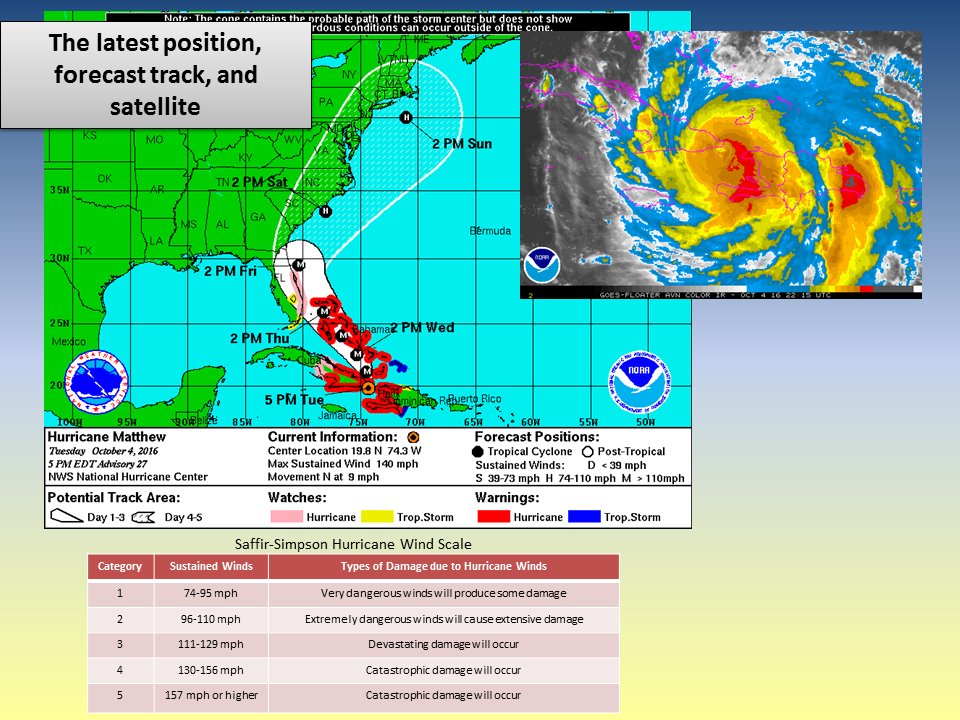
Re: Huracán Matthew
BULLETIN
HURRICANE MATTHEW ADVISORY NUMBER 27
NWS NATIONAL HURRICANE CENTER MIAMI FL AL142016
500 PM EDT TUE OCT 04 2016
...NORTHERN EYEWALL OF EXTREMELY DANGEROUS HURRICANE MATTHEW
ALREADY POUNDING THE EASTERN TIP OF CUBA...
SUMMARY OF 500 PM EDT...2100 UTC...INFORMATION
----------------------------------------------
LOCATION...19.8N 74.3W
ABOUT 65 MI...105 KM ESE OF GUANTANAMO CUBA
ABOUT 30 MI...45 KM SSW OF THE EASTERN TIP OF CUBA
MAXIMUM SUSTAINED WINDS...140 MPH...220 KM/H
PRESENT MOVEMENT...N OR 360 DEGREES AT 9 MPH...15 KM/H
MINIMUM CENTRAL PRESSURE...949 MB...28.03 INCHES
WATCHES AND WARNINGS
--------------------
CHANGES WITH THIS ADVISORY:
The Hurricane Watch has been extended southward to Golden Beach,
Florida.
SUMMARY OF WATCHES AND WARNINGS IN EFFECT:
A Hurricane Warning is in effect for...
* Haiti
* Cuban provinces of Guantanamo, Santiago de Cuba, Holguin, Granma,
and Las Tunas
* Southeastern Bahamas, including the Inaguas, Mayaguana, Acklins,
Crooked Island, Long Cay, and Ragged Island
* Central Bahamas, including Long Island, Exuma, Rum Cay,
San Salvador, and Cat Island
* Northwestern Bahamas, including the Abacos, Andros Island,
Berry Islands, Bimini, Eleuthera, Grand Bahama Island, and
New Providence
A Hurricane Watch is in effect for...
* Cuban province of Camaguey
* Golden Beach to the Volusia/Brevard county line
A Tropical Storm Warning is in effect for...
* Dominican Republic from Barahona westward to the border with Haiti
* Turks and Caicos Islands
A Tropical Storm Watch is in effect for...
* Dominican Republic from Puerto Plata westward to the border with
Haiti
* Seven Mile Bridge to south of Golden Beach
* Lake Okeechobee
Interests elsewhere in the Florida Peninsula and the Florida Keys
should monitor the progress of Matthew.
For storm information specific to your area in the United States,
including possible inland watches and warnings, please monitor
products issued by your local National Weather Service forecast
office. For storm information specific to your area outside the
United States, please monitor products issued by your national
meteorological service.
DISCUSSION AND 48-HOUR OUTLOOK
------------------------------
At 500 PM EDT (2100 UTC), the eye of Hurricane Matthew was located
near latitude 19.8 North, longitude 74.3 West. Matthew is moving
toward the north near 9 mph (15 km/h). On this track the eye of
Matthew will move over the extreme portion of eastern Cuba in the
next few hours. A turn toward the north-northwest is expected by
Wednesday, followed by a northwest turn Wednesday night. Matthew is
expected to move near or over portions of the southeastern and
central Bahamas tonight and Wednesday, and approach the northwestern
Bahamas Wednesday night.
Maximum sustained winds are near 140 mph (220 km/h) with higher
gusts. Matthew is a category 4 hurricane on the Saffir-Simpson
Hurricane Wind Scale. Some fluctuations in intensity are possible
during the next couple of days, but Matthew is expected to remain a
powerful hurricane through at least Thursday night.
Hurricane-force winds extend outward up to 45 miles (75 km) from the
center and tropical-storm-force winds extend outward up to 175 miles
(280 km).
The estimated minimum central pressure is 949 mb (28.03 inches).
HAZARDS AFFECTING LAND
----------------------
WIND: Hurricane conditions are still affecting portions of Haiti.
Hurricane conditions are likely occuring over eastern Cuba, and will
begin in the southeastern Bahamas this evening, the central Bahamas
on Wednesday, and the northwestern Bahamas Wednesday night.
Tropical storm conditions are expected to continue spreading
across the remainder of Haiti, eastern Cuba and the southeastern
Bahamas tonight, and should reach the central and northwestern
Bahamas on Wednesday, making outside preparations difficult or
dangerous. Tropical storm conditions are still occurring in portions
the Dominican Republic within the warning area, and these conditions
will spread northward into the Turks and Caicos Islands tonight.
Hurricane conditions are possible in the hurricane watch areas in
Cuba tonight with tropical storm conditions possible later tonight.
Hurricane conditions are possible within the hurricane watch
area in Florida by late Thursday, with tropical storm conditions
possible by early Thursday. Tropical storm condition are also
possible in the Florida tropical storm watch area by early Thursday.
RAINFALL: Matthew is expected to produce total rainfall amounts in
the following areas:
Southern Haiti and southwestern Dominican Republic...15 to 25
inches, isolated 40 inches
Eastern Cuba and northwestern Haiti...8 to 12 inches, isolated
20 inches
Eastern Jamaica...4 to 6 inches, isolated 12 inches
The Bahamas...8 to 12 inches, isolated 15 inches
Turks and Caicos Islands...2 to 5 inches, isolated 8 inches
Northeastern Haiti and the Northern Dominican Republic...1 to 3
inches, isolated 5 inches
Western Jamaica...1 to 2 inches, isolated 3 inches
Upper Florida Keys northward to coastal east-central Florida....4 to
7 inches, isolated 10 inches
Middle to Lower Florida Keys....1 to 3 inches, isolated 5 inches
Life-threatening flash floods and mudslides are likely from this
rainfall in southern and northwestern Haiti, the southwestern
Dominican Republic, and eastern Cuba.
STORM SURGE: The combination of a dangerous storm surge and large
and destructive waves could raise water levels by as much as the
following amounts above normal tide levels...
Southern Coast of Cuba east of Cabo Cruz...7 to 11 feet
South Coast of Haiti...7 to 10 feet
Northern Coast of Cuba east of Camaguey...4 to 6 feet
Gulf of Gonave in Haiti...3 to 5 feet
Southern coast of the Dominican Republic...1 to 3 feet
The Bahamas...10 to 15 feet
The water could reach the following heights above ground if the peak
surge occurs at the time of high tide...
North Palm Beach to the Volusia/Brevard county line...3 to 5 ft
Surge-related flooding depends on the relative timing of the surge
and the tidal cycle, and can vary greatly over short distances.
Large waves generated by Matthew will cause water rises to occur
well in advance of and well away from the track of the center.
The combination of a dangerous storm surge and the tide will cause
normally dry areas near the coast to be flooded by rising waters
moving inland from the shoreline. There is the potential for
life-threatening inundation during the next 48 hours along
the Florida east coast from North Palm Beach to the Volusia/Brevard
county line. For a depiction of areas at risk, please see the
Prototype National Weather Service Storm Surge Watch/Warning
Graphic. For information specific to your area, please see products
issued by your local National Weather Service forecast office.
The Prototype Storm Surge Watch/Warning Graphic is a depiction of
areas that would qualify for inclusion under a storm surge watch or
warning currently under development by the National Weather Service
and planned for operational use in 2017. The Prototype Graphic is
available at hurricanes.gov.
SURF: Swells generated by Matthew will continue to affect portions
of the coasts of Hispaniola, Jamaica, eastern Cuba, and the
Caribbean coastline of Central America during the next few
days. Swells from Matthew will begin affecting portions of the
Bahamas on Tuesday. These swells are likely to cause life-
threatening surf and rip current conditions. Please consult
products from your local weather office.
NEXT ADVISORY
-------------
Next intermediate advisory at 800 PM EDT.
Next complete advisory at 1100 PM EDT.
$$
Forecaster Avila
emh- huracan es simplemente ahora Edgardo. Importante: Phil Klotzbach, recordó que "el mejor momento para prepararse para los huracanes es cuando todavía no hay huracanes".
-
StormWatch
- Cat. 3
- Posts: 3721
- Joined: Thu Aug 06, 2015 11:39 am
- Location: Texas, USA
Re: Huracán Matthew
Intacto Matthew! 
Member Since 2005
For official information, please refer to NHC: https://www.nhc.noaa.gov
Hurricane’s hit Puerto Rico:
San Felipe 1928, San Ciprián 1932, Santa Clara 1956, Hugo 1989, Marilyn 1995, Hortense 1996, Georges 1998, Maria 2017, Fiona 2022
Model Runs:
GFS:
[5:30 AM/PM, 11:30 AM/PM]
HWRF, GFDL, UKMET, NAVGEM:
[6:30-8:00 AM/PM, 12:30-2:00 AM/PM]
ECMWF:
[1:45 AM/PM]
For official information, please refer to NHC: https://www.nhc.noaa.gov
Hurricane’s hit Puerto Rico:
San Felipe 1928, San Ciprián 1932, Santa Clara 1956, Hugo 1989, Marilyn 1995, Hortense 1996, Georges 1998, Maria 2017, Fiona 2022
Model Runs:
GFS:
[5:30 AM/PM, 11:30 AM/PM]
HWRF, GFDL, UKMET, NAVGEM:
[6:30-8:00 AM/PM, 12:30-2:00 AM/PM]
ECMWF:
[1:45 AM/PM]
-
StormWatch
- Cat. 3
- Posts: 3721
- Joined: Thu Aug 06, 2015 11:39 am
- Location: Texas, USA
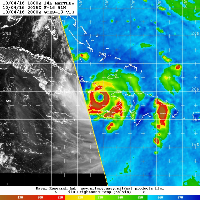
Re: Huracán Matthew
Latest:
Member Since 2005
For official information, please refer to NHC: https://www.nhc.noaa.gov
Hurricane’s hit Puerto Rico:
San Felipe 1928, San Ciprián 1932, Santa Clara 1956, Hugo 1989, Marilyn 1995, Hortense 1996, Georges 1998, Maria 2017, Fiona 2022
Model Runs:
GFS:
[5:30 AM/PM, 11:30 AM/PM]
HWRF, GFDL, UKMET, NAVGEM:
[6:30-8:00 AM/PM, 12:30-2:00 AM/PM]
ECMWF:
[1:45 AM/PM]
For official information, please refer to NHC: https://www.nhc.noaa.gov
Hurricane’s hit Puerto Rico:
San Felipe 1928, San Ciprián 1932, Santa Clara 1956, Hugo 1989, Marilyn 1995, Hortense 1996, Georges 1998, Maria 2017, Fiona 2022
Model Runs:
GFS:
[5:30 AM/PM, 11:30 AM/PM]
HWRF, GFDL, UKMET, NAVGEM:
[6:30-8:00 AM/PM, 12:30-2:00 AM/PM]
ECMWF:
[1:45 AM/PM]
-
StormWatch
- Cat. 3
- Posts: 3721
- Joined: Thu Aug 06, 2015 11:39 am
- Location: Texas, USA
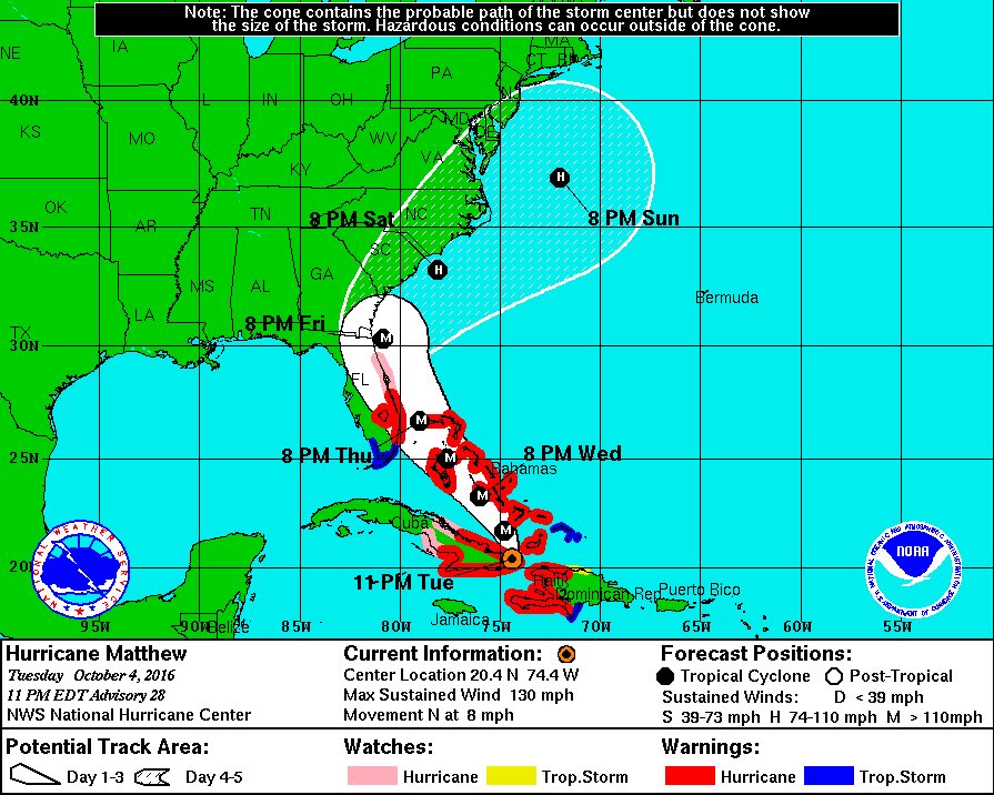
Re: Huracán Matthew
At 8pm
000
WTNT34 KNHC 042354
TCPAT4
BULLETIN
HURRICANE MATTHEW INTERMEDIATE ADVISORY NUMBER 27A
NWS NATIONAL HURRICANE CENTER MIAMI FL AL142016
800 PM EDT TUE OCT 04 2016
...THE EYE OF POWERFUL HURRICANE MATTHEW MAKING LANDFALL NEAR THE
EASTERN TIP OF CUBA...
SUMMARY OF 800 PM EDT...0000 UTC...INFORMATION
----------------------------------------------
LOCATION...20.1N 74.3W
ABOUT 15 MI...20 KM SW OF THE EASTERN TIP OF CUBA
ABOUT 55 MI...90 KM ENE OF GUANTANAMO CUBA
MAXIMUM SUSTAINED WINDS...140 MPH...220 KM/H
PRESENT MOVEMENT...N OR 360 DEGREES AT 9 MPH...15 KM/H
MINIMUM CENTRAL PRESSURE...949 MB...28.03 INCHES
WATCHES AND WARNINGS
--------------------
CHANGES WITH THIS ADVISORY:
None.
SUMMARY OF WATCHES AND WARNINGS IN EFFECT:
A Hurricane Warning is in effect for...
* Haiti
* Cuban provinces of Guantanamo, Santiago de Cuba, Holguin, Granma,
and Las Tunas
* Southeastern Bahamas, including the Inaguas, Mayaguana, Acklins,
Crooked Island, Long Cay, and Ragged Island
* Central Bahamas, including Long Island, Exuma, Rum Cay,
San Salvador, and Cat Island
* Northwestern Bahamas, including the Abacos, Andros Island,
Berry Islands, Bimini, Eleuthera, Grand Bahama Island, and
New Providence
A Hurricane Watch is in effect for...
* Cuban province of Camaguey
* Golden Beach to the Volusia/Brevard county line
* Lake Okeechobee
A Tropical Storm Warning is in effect for...
* Dominican Republic from Barahona westward to the border with Haiti
* Turks and Caicos Islands
A Tropical Storm Watch is in effect for...
* Dominican Republic from Puerto Plata westward to the border with
Haiti
* Seven Mile Bridge to south of Golden Beach
Interests elsewhere in the Florida Peninsula and the Florida Keys
should monitor the progress of Matthew.
For storm information specific to your area in the United
States, including possible inland watches and warnings, please
monitor products issued by your local National Weather Service
forecast office. For storm information specific to your area outside
the United States, please monitor products issued by your national
meteorological service.
DISCUSSION AND 48-HOUR OUTLOOK
------------------------------
At 800 PM EDT (0000 UTC), radar data from Guantanamo, Cuba, along
with reports from an Air Force Reserve Hurricane Hunter aircraft,
indicate that the eye of Hurricane Matthew was located near latitude
20.1 North, longitude 74.3 West. The center of the eye of Matthew
made landfall near Juaco, Cuba, around 800 PM EDT (0000 UTC).
Matthew is moving toward the north near 9 mph (15 km/h), and this
motion is expected to continue through this evening. A turn toward
the north-northwest is expected on Wednesday, followed by a
northwest turn Wednesday night. Matthew is forecast to move near or
over portions of the southeastern and central Bahamas Wednesday, and
approach the northwestern Bahamas Wednesday night.
Maximum sustained winds are near 140 mph (220 km/h) with higher
gusts. Matthew remains a category 4 hurricane on the Saffir-Simpson
Hurricane Wind Scale. Some fluctuations in intensity are possible
during the next couple of days, but Matthew is expected to remain a
powerful hurricane through at least Thursday night.
Hurricane-force winds extend outward up to 45 miles (75 km) from
the center and tropical-storm-force winds extend outward up to 175
miles (280 km).
The minimum central pressure recently reported by reconnaissance
aircraft was 949 mb (28.03 inches).
HAZARDS AFFECTING LAND
----------------------
WIND: Hurricane conditions are still affecting portions of
Haiti. Hurricane conditions are likely occuring over eastern Cuba,
and will begin in the southeastern Bahamas by Wednesday morning, the
central Bahamas on Wednesday, and the northwestern Bahamas Wednesday
night.
Tropical storm conditions are expected to continue spreading
across the remainder of Haiti, eastern Cuba and the southeastern
Bahamas tonight, and should reach the central and northwestern
Bahamas on Wednesday, making outside preparations difficult or
dangerous. Tropical storm conditions are still occurring in portions
the Dominican Republic within the warning area, and these conditions
will spread northward into the Turks and Caicos Islands tonight.
Hurricane conditions are possible in the hurricane watch areas in
Cuba tonight with tropical storm conditions possible later tonight.
Hurricane conditions are possible within the hurricane watch
area in Florida by late Thursday, with tropical storm conditions
possible by early Thursday. Tropical storm condition are also
possible in the Florida tropical storm watch area by early Thursday.
RAINFALL: Matthew is expected to produce total rainfall amounts in
the following areas:
Southern Haiti and southwestern Dominican Republic...15 to 25
inches, isolated 40 inches
Eastern Cuba and northwestern Haiti...8 to 12 inches, isolated
20 inches
Eastern Jamaica...4 to 6 inches, isolated 12 inches
The Bahamas...8 to 12 inches, isolated 15 inches
Turks and Caicos Islands...2 to 5 inches, isolated 8 inches
Northeastern Haiti and the Northern Dominican Republic...1 to 3
inches, isolated 5 inches
Western Jamaica...1 to 2 inches, isolated 3 inches
Upper Florida Keys northward to coastal east-central Florida....4 to
7 inches, isolated 10 inches
Middle to Lower Florida Keys....1 to 3 inches, isolated 5 inches
Life-threatening flash floods and mudslides are likely from this
rainfall in southern and northwestern Haiti, the southwestern
Dominican Republic, and eastern Cuba.
STORM SURGE: The combination of a dangerous storm surge and large
and destructive waves could raise water levels by as much as the
following amounts above normal tide levels...
Southern Coast of Cuba east of Cabo Cruz...7 to 11 feet
South Coast of Haiti...7 to 10 feet
Northern Coast of Cuba east of Camaguey...4 to 6 feet
Gulf of Gonave in Haiti...3 to 5 feet
Southern coast of the Dominican Republic...1 to 3 feet
The Bahamas...10 to 15 feet
The water could reach the following heights above ground if the peak
surge occurs at the time of high tide...
North Palm Beach to the Volusia/Brevard county line...3 to 5 ft
Surge-related flooding depends on the relative timing of the surge
and the tidal cycle, and can vary greatly over short distances.
Large waves generated by Matthew will cause water rises to occur
well in advance of and well away from the track of the center.
The combination of a dangerous storm surge and the tide will cause
normally dry areas near the coast to be flooded by rising waters
moving inland from the shoreline. There is the potential for
life-threatening inundation during the next 48 hours along
the Florida east coast from North Palm Beach to the Volusia/Brevard
county line. For a depiction of areas at risk, please see the
Prototype National Weather Service Storm Surge Watch/Warning
Graphic. For information specific to your area, please see products
issued by your local National Weather Service forecast office.
The Prototype Storm Surge Watch/Warning Graphic is a depiction of
areas that would qualify for inclusion under a storm surge watch or
warning currently under development by the National Weather Service
and planned for operational use in 2017. The Prototype Graphic is
available at hurricanes.gov.
SURF: Swells generated by Matthew will continue to affect portions
of the coasts of Hispaniola, Jamaica, eastern Cuba, and the
Caribbean coastline of Central America during the next few
days. Swells from Matthew will begin affecting portions of the
Bahamas on Tuesday. These swells are likely to cause life-
threatening surf and rip current conditions. Please consult
products from your local weather office.
NEXT ADVISORY
-------------
Next complete advisory at 1100 PM EDT.
$$
Forecaster Stewart
Member Since 2005
For official information, please refer to NHC: https://www.nhc.noaa.gov
Hurricane’s hit Puerto Rico:
San Felipe 1928, San Ciprián 1932, Santa Clara 1956, Hugo 1989, Marilyn 1995, Hortense 1996, Georges 1998, Maria 2017, Fiona 2022
Model Runs:
GFS:
[5:30 AM/PM, 11:30 AM/PM]
HWRF, GFDL, UKMET, NAVGEM:
[6:30-8:00 AM/PM, 12:30-2:00 AM/PM]
ECMWF:
[1:45 AM/PM]
For official information, please refer to NHC: https://www.nhc.noaa.gov
Hurricane’s hit Puerto Rico:
San Felipe 1928, San Ciprián 1932, Santa Clara 1956, Hugo 1989, Marilyn 1995, Hortense 1996, Georges 1998, Maria 2017, Fiona 2022
Model Runs:
GFS:
[5:30 AM/PM, 11:30 AM/PM]
HWRF, GFDL, UKMET, NAVGEM:
[6:30-8:00 AM/PM, 12:30-2:00 AM/PM]
ECMWF:
[1:45 AM/PM]
-
StormWatch
- Cat. 3
- Posts: 3721
- Joined: Thu Aug 06, 2015 11:39 am
- Location: Texas, USA
Re: Huracán Matthew
Hurricane Warnings NOW in Florida.
#Matthew
#Matthew
Member Since 2005
For official information, please refer to NHC: https://www.nhc.noaa.gov
Hurricane’s hit Puerto Rico:
San Felipe 1928, San Ciprián 1932, Santa Clara 1956, Hugo 1989, Marilyn 1995, Hortense 1996, Georges 1998, Maria 2017, Fiona 2022
Model Runs:
GFS:
[5:30 AM/PM, 11:30 AM/PM]
HWRF, GFDL, UKMET, NAVGEM:
[6:30-8:00 AM/PM, 12:30-2:00 AM/PM]
ECMWF:
[1:45 AM/PM]
For official information, please refer to NHC: https://www.nhc.noaa.gov
Hurricane’s hit Puerto Rico:
San Felipe 1928, San Ciprián 1932, Santa Clara 1956, Hugo 1989, Marilyn 1995, Hortense 1996, Georges 1998, Maria 2017, Fiona 2022
Model Runs:
GFS:
[5:30 AM/PM, 11:30 AM/PM]
HWRF, GFDL, UKMET, NAVGEM:
[6:30-8:00 AM/PM, 12:30-2:00 AM/PM]
ECMWF:
[1:45 AM/PM]