


Saludos a todos;
Esa cosita nada que ver con nosotros, muy alta, para estar tan demasiado lejos.
Las demas han traido algo de emotividad pero nada de nada, como dijo alguien por ahi, ha sido una temporada decepcionante para nosotros, ahora para la Florida y la costa este de USA ha sido entretenida!!!
Depresión Tropical Karl (Invest 95L)
Re: Invest 95L 50%-60% Anaranjado (Pouch 34L)
Disclaimer: "Solo soy otro fan de la meteorolgia...para informacion mas precisa vaya a buscarla del NHC y del SNM.... No soy la voz oficial de comunicaciones de la AAA asi que pendiente a sus anuncios oficiales en los medios de comunicación de prensa escrita, radial, televisiva, redes socials, etc."
-
StormWatch
- Cat. 3

- Posts: 3721
- Joined: Thu Aug 06, 2015 11:39 am
- Location: Texas, USA
Re: Invest 95L 50%-60% Anaranjado (Pouch 34L)
5pm
Member Since 2005
For official information, please refer to NHC: https://www.nhc.noaa.gov
Hurricane’s hit Puerto Rico:
San Felipe 1928, San Ciprián 1932, Santa Clara 1956, Hugo 1989, Marilyn 1995, Hortense 1996, Georges 1998, Maria 2017, Fiona 2022
Model Runs:
GFS:
[5:30 AM/PM, 11:30 AM/PM]
HWRF, GFDL, UKMET, NAVGEM:
[6:30-8:00 AM/PM, 12:30-2:00 AM/PM]
ECMWF:
[1:45 AM/PM]
-
StormWatch
- Cat. 3
- Posts: 3721
- Joined: Thu Aug 06, 2015 11:39 am
- Location: Texas, USA
Re: Invest 95L 50%-60% Anaranjado (Pouch 34L)
Tropical Depression #Twelve

Member Since 2005
For official information, please refer to NHC: https://www.nhc.noaa.gov
Hurricane’s hit Puerto Rico:
San Felipe 1928, San Ciprián 1932, Santa Clara 1956, Hugo 1989, Marilyn 1995, Hortense 1996, Georges 1998, Maria 2017, Fiona 2022
Model Runs:
GFS:
[5:30 AM/PM, 11:30 AM/PM]
HWRF, GFDL, UKMET, NAVGEM:
[6:30-8:00 AM/PM, 12:30-2:00 AM/PM]
ECMWF:
[1:45 AM/PM]
For official information, please refer to NHC: https://www.nhc.noaa.gov
Hurricane’s hit Puerto Rico:
San Felipe 1928, San Ciprián 1932, Santa Clara 1956, Hugo 1989, Marilyn 1995, Hortense 1996, Georges 1998, Maria 2017, Fiona 2022
Model Runs:
GFS:
[5:30 AM/PM, 11:30 AM/PM]
HWRF, GFDL, UKMET, NAVGEM:
[6:30-8:00 AM/PM, 12:30-2:00 AM/PM]
ECMWF:
[1:45 AM/PM]
-
StormWatch
- Cat. 3
- Posts: 3721
- Joined: Thu Aug 06, 2015 11:39 am
- Location: Texas, USA
Re: Invest 95L 50%-60% Anaranjado (Pouch 34L)
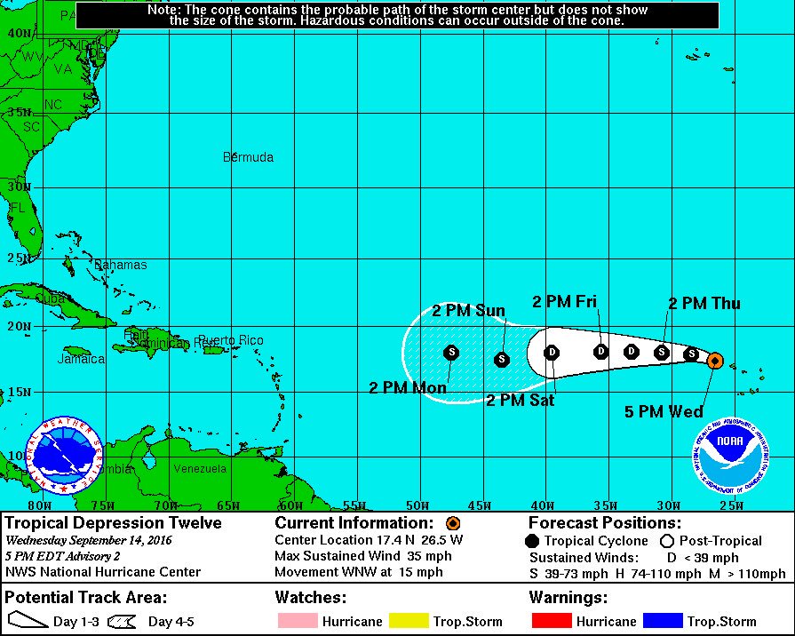
000
WTNT32 KNHC 142036
TCPAT2
BULLETIN
TROPICAL DEPRESSION TWELVE ADVISORY NUMBER 2
NWS NATIONAL HURRICANE CENTER MIAMI FL AL122016
500 PM AST WED SEP 14 2016
...CENTER OF THE DEPRESSION NOW WEST OF THE CABO VERDE ISLANDS...
SUMMARY OF 500 PM AST...2100 UTC...INFORMATION
----------------------------------------------
LOCATION...17.4N 26.5W
ABOUT 190 MI...310 KM WNW OF THE CABO VERDE ISLANDS
MAXIMUM SUSTAINED WINDS...35 MPH...55 KM/H
PRESENT MOVEMENT...WNW OR 295 DEGREES AT 15 MPH...24 KM/H
MINIMUM CENTRAL PRESSURE...1009 MB...29.80 INCHES
WATCHES AND WARNINGS
--------------------
There are no coastal watches or warnings in effect.
DISCUSSION AND 48-HOUR OUTLOOK
------------------------------
At 500 PM AST (2100 UTC), the center of Tropical Depression Twelve
was located near latitude 17.4 North, longitude 26.5 West. The
depression is moving toward the west-northwest near 15 mph (24 km/h)
and a gradual turn toward the west is expected during the next
couple of days. On the forecast track, the center of the depression
should move away from the Cabo Verde Islands tonight and Thursday.
Maximum sustained winds are near 35 mph (55 km/h) with higher gusts.
Slight strengthening is expected during the next 24 hours, and the
depression could become a tropical storm tonight or on Thursday.
After that time, some weakening could occur as the cyclone
encounters unfavorable upper-level winds.
The estimated minimum central pressure is 1009 mb (29.80 inches).
HAZARDS AFFECTING LAND
----------------------
WIND: Gusty winds are possible over portions of the Cabo Verde
Islands through tonight.
RAINFALL: Locally heavy rains are expected over portions of the Cabo
Verde Islands through Thursday.
NEXT ADVISORY
-------------
Next complete advisory at 1100 PM AST.
$$
Forecaster Beven
Member Since 2005
For official information, please refer to NHC: https://www.nhc.noaa.gov
Hurricane’s hit Puerto Rico:
San Felipe 1928, San Ciprián 1932, Santa Clara 1956, Hugo 1989, Marilyn 1995, Hortense 1996, Georges 1998, Maria 2017, Fiona 2022
Model Runs:
GFS:
[5:30 AM/PM, 11:30 AM/PM]
HWRF, GFDL, UKMET, NAVGEM:
[6:30-8:00 AM/PM, 12:30-2:00 AM/PM]
ECMWF:
[1:45 AM/PM]
For official information, please refer to NHC: https://www.nhc.noaa.gov
Hurricane’s hit Puerto Rico:
San Felipe 1928, San Ciprián 1932, Santa Clara 1956, Hugo 1989, Marilyn 1995, Hortense 1996, Georges 1998, Maria 2017, Fiona 2022
Model Runs:
GFS:
[5:30 AM/PM, 11:30 AM/PM]
HWRF, GFDL, UKMET, NAVGEM:
[6:30-8:00 AM/PM, 12:30-2:00 AM/PM]
ECMWF:
[1:45 AM/PM]
-
StormWatch
- Cat. 3
- Posts: 3721
- Joined: Thu Aug 06, 2015 11:39 am
- Location: Texas, USA
Re: Invest 95L 50%-60% Anaranjado (Pouch 34L)
000
WTNT42 KNHC 142040
TCDAT2
TROPICAL DEPRESSION TWELVE DISCUSSION NUMBER 2
NWS NATIONAL HURRICANE CENTER MIAMI FL AL122016
500 PM AST WED SEP 14 2016
The depression has not become better organized since the last
advisory, with the most concentrated convection now in a cluster
just west of the estimated center position. The initial intensity
remains 30 kt in best agreement with a satellite intensity estimate
from SAB.
The initial motion is a somewhat uncertain 295/13 kt. A low- to
mid-level ridge should steer the system west-northwestward and then
westward during the forecast period, with some decrease in forward
speed after 36-48 hours as the ridge weakens slightly. The new
forecast track is similar to, but a little north of, the previous
track based on a slight northward shift in the track guidance.
Some strengthening is expected during the next 12 hours or so. After
that, the cyclone will encounter strong westerly vertical wind shear
caused by a developing upper-level trough near and north of the
cyclone. This, combined with passage over sea-surface temperatures
of about 26C-27C, should lead to weakening, and the intensity
forecast shows the system weakening back to a depression by 36
hours. Near the end of the forecast period, the dynamical models
continue to diverge on the evolution of the upper-level winds, with
the ECMWF and UKMET forecasting a more favorable ridge pattern near
the cyclone, whereas the GFS has an upper-level trough close by.
Based on these conflicting models, the forecast leans toward the
ECMWF/UKMET scenario and shows some re-intensification by 120 hours.
An alternative scenario is that the cyclone degenerates into a broad
low pressure area or tropical wave as forecast by the GFS. Overall,
the intensity forecast remains on the low side of the guidance in
best agreement with the LGEM.
Gusty winds remain possible over the Cabo Verde Islands tonight,
whereas locally heavy rains will remain possible through Thursday.
FORECAST POSITIONS AND MAX WINDS
INIT 14/2100Z 17.4N 26.5W 30 KT 35 MPH
12H 15/0600Z 17.9N 28.4W 35 KT 40 MPH
24H 15/1800Z 18.0N 30.8W 35 KT 40 MPH
36H 16/0600Z 18.1N 33.2W 30 KT 35 MPH
48H 16/1800Z 18.1N 35.6W 30 KT 35 MPH
72H 17/1800Z 18.0N 39.5W 30 KT 35 MPH
96H 18/1800Z 17.5N 43.5W 35 KT 40 MPH
120H 19/1800Z 18.0N 47.5W 40 KT 45 MPH
$$
Forecaster Beven
Member Since 2005
For official information, please refer to NHC: https://www.nhc.noaa.gov
Hurricane’s hit Puerto Rico:
San Felipe 1928, San Ciprián 1932, Santa Clara 1956, Hugo 1989, Marilyn 1995, Hortense 1996, Georges 1998, Maria 2017, Fiona 2022
Model Runs:
GFS:
[5:30 AM/PM, 11:30 AM/PM]
HWRF, GFDL, UKMET, NAVGEM:
[6:30-8:00 AM/PM, 12:30-2:00 AM/PM]
ECMWF:
[1:45 AM/PM]
For official information, please refer to NHC: https://www.nhc.noaa.gov
Hurricane’s hit Puerto Rico:
San Felipe 1928, San Ciprián 1932, Santa Clara 1956, Hugo 1989, Marilyn 1995, Hortense 1996, Georges 1998, Maria 2017, Fiona 2022
Model Runs:
GFS:
[5:30 AM/PM, 11:30 AM/PM]
HWRF, GFDL, UKMET, NAVGEM:
[6:30-8:00 AM/PM, 12:30-2:00 AM/PM]
ECMWF:
[1:45 AM/PM]


