
70-70
Jaaaa este foro esta mas apagao q la quiebra q tiene Puerto Rico! Válgame Dios Santoo
Depresión Tropical Karl (Invest 95L)
-
StormWatch
- Cat. 3

- Posts: 3721
- Joined: Thu Aug 06, 2015 11:39 am
- Location: Texas, USA
Re: Invest 95L 50%-60% Anaranjado (Pouch 34L)
Member Since 2005
For official information, please refer to NHC: https://www.nhc.noaa.gov
Hurricane’s hit Puerto Rico:
San Felipe 1928, San Ciprián 1932, Santa Clara 1956, Hugo 1989, Marilyn 1995, Hortense 1996, Georges 1998, Maria 2017, Fiona 2022
Model Runs:
GFS:
[5:30 AM/PM, 11:30 AM/PM]
HWRF, GFDL, UKMET, NAVGEM:
[6:30-8:00 AM/PM, 12:30-2:00 AM/PM]
ECMWF:
[1:45 AM/PM]
-
StormWatch
- Cat. 3
- Posts: 3721
- Joined: Thu Aug 06, 2015 11:39 am
- Location: Texas, USA
Re: Invest 95L 50%-60% Anaranjado (Pouch 34L)
Invest 95L
Tiene 70% - 70%
Tiene 70% - 70%
Member Since 2005
For official information, please refer to NHC: https://www.nhc.noaa.gov
Hurricane’s hit Puerto Rico:
San Felipe 1928, San Ciprián 1932, Santa Clara 1956, Hugo 1989, Marilyn 1995, Hortense 1996, Georges 1998, Maria 2017, Fiona 2022
Model Runs:
GFS:
[5:30 AM/PM, 11:30 AM/PM]
HWRF, GFDL, UKMET, NAVGEM:
[6:30-8:00 AM/PM, 12:30-2:00 AM/PM]
ECMWF:
[1:45 AM/PM]
For official information, please refer to NHC: https://www.nhc.noaa.gov
Hurricane’s hit Puerto Rico:
San Felipe 1928, San Ciprián 1932, Santa Clara 1956, Hugo 1989, Marilyn 1995, Hortense 1996, Georges 1998, Maria 2017, Fiona 2022
Model Runs:
GFS:
[5:30 AM/PM, 11:30 AM/PM]
HWRF, GFDL, UKMET, NAVGEM:
[6:30-8:00 AM/PM, 12:30-2:00 AM/PM]
ECMWF:
[1:45 AM/PM]
Re: Invest 95L 50%-60% Anaranjado (Pouch 34L)
StormWatch wrote:70-70
Jaaaa este foro esta mas apagao q la quiebra q tiene Puerto Rico! Válgame Dios Santoo
-
StormWatch
- Cat. 3
- Posts: 3721
- Joined: Thu Aug 06, 2015 11:39 am
- Location: Texas, USA
Re: Invest 95L 50%-60% Anaranjado (Pouch 34L)
Es Depresion!
Member Since 2005
For official information, please refer to NHC: https://www.nhc.noaa.gov
Hurricane’s hit Puerto Rico:
San Felipe 1928, San Ciprián 1932, Santa Clara 1956, Hugo 1989, Marilyn 1995, Hortense 1996, Georges 1998, Maria 2017, Fiona 2022
Model Runs:
GFS:
[5:30 AM/PM, 11:30 AM/PM]
HWRF, GFDL, UKMET, NAVGEM:
[6:30-8:00 AM/PM, 12:30-2:00 AM/PM]
ECMWF:
[1:45 AM/PM]
For official information, please refer to NHC: https://www.nhc.noaa.gov
Hurricane’s hit Puerto Rico:
San Felipe 1928, San Ciprián 1932, Santa Clara 1956, Hugo 1989, Marilyn 1995, Hortense 1996, Georges 1998, Maria 2017, Fiona 2022
Model Runs:
GFS:
[5:30 AM/PM, 11:30 AM/PM]
HWRF, GFDL, UKMET, NAVGEM:
[6:30-8:00 AM/PM, 12:30-2:00 AM/PM]
ECMWF:
[1:45 AM/PM]
-
StormWatch
- Cat. 3
- Posts: 3721
- Joined: Thu Aug 06, 2015 11:39 am
- Location: Texas, USA
Re: Invest 95L 50%-60% Anaranjado (Pouch 34L)
000
WTNT32 KNHC 141441
TCPAT2
BULLETIN
TROPICAL DEPRESSION TWELVE ADVISORY NUMBER 1
NWS NATIONAL HURRICANE CENTER MIAMI FL AL122016
1100 AM AST WED SEP 14 2016
...NEW TROPICAL DEPRESSION FORMS OVER THE WESTERN CABO VERDE
ISLANDS...
SUMMARY OF 1100 AM AST...1500 UTC...INFORMATION
-----------------------------------------------
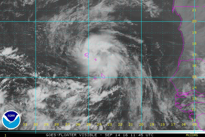
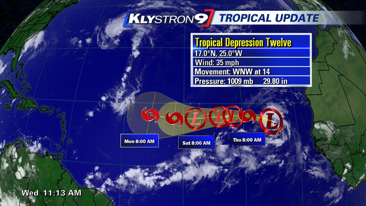
LOCATION...17.0N 25.0W
ABOUT 95 MI...155 KM NW OF THE CABO VERDE ISLANDS
MAXIMUM SUSTAINED WINDS...35 MPH...55 KM/H
PRESENT MOVEMENT...WNW OR 300 DEGREES AT 14 MPH...22 KM/H
MINIMUM CENTRAL PRESSURE...1009 MB...29.80 INCHES
WATCHES AND WARNINGS
--------------------
There are no coastal watches or warnings in effect.
DISCUSSION AND 48-HOUR OUTLOOK
------------------------------
At 1100 AM AST (1500 UTC), the center of Tropical Depression Twelve
was located near latitude 17.0 North, longitude 25.0 West. The
depression is moving toward the west-northwest near 14 mph (22 km/h)
and a gradual turn toward the west is expected during the next
couple of days. On the forecast track, the center of the depression
should move through the western islands of Cabo Verde this
afternoon and move away from the islands tonight.
Maximum sustained winds are near 35 mph (55 km/h) with higher gusts.
Slight strengthening is expected during the next 24 hours, and the
depression could become a tropical storm tonight. After that time,
some weakening could occur as the cyclone encounters unfavorable
upper-level winds.
The estimated minimum central pressure is 1009 mb (29.80 inches).
HAZARDS AFFECTING LAND
----------------------
WIND: Gusty winds are possible over portions of the Cabo Verde
Islands through tonight.
RAINFALL: Locally heavy rains are expected over portions of the Cabo
Verde Islands through Thursday.
NEXT ADVISORY
-------------
Next complete advisory at 500 PM AST.
$$
Forecaster Beven
WTNT32 KNHC 141441
TCPAT2
BULLETIN
TROPICAL DEPRESSION TWELVE ADVISORY NUMBER 1
NWS NATIONAL HURRICANE CENTER MIAMI FL AL122016
1100 AM AST WED SEP 14 2016
...NEW TROPICAL DEPRESSION FORMS OVER THE WESTERN CABO VERDE
ISLANDS...
SUMMARY OF 1100 AM AST...1500 UTC...INFORMATION
-----------------------------------------------
LOCATION...17.0N 25.0W
ABOUT 95 MI...155 KM NW OF THE CABO VERDE ISLANDS
MAXIMUM SUSTAINED WINDS...35 MPH...55 KM/H
PRESENT MOVEMENT...WNW OR 300 DEGREES AT 14 MPH...22 KM/H
MINIMUM CENTRAL PRESSURE...1009 MB...29.80 INCHES
WATCHES AND WARNINGS
--------------------
There are no coastal watches or warnings in effect.
DISCUSSION AND 48-HOUR OUTLOOK
------------------------------
At 1100 AM AST (1500 UTC), the center of Tropical Depression Twelve
was located near latitude 17.0 North, longitude 25.0 West. The
depression is moving toward the west-northwest near 14 mph (22 km/h)
and a gradual turn toward the west is expected during the next
couple of days. On the forecast track, the center of the depression
should move through the western islands of Cabo Verde this
afternoon and move away from the islands tonight.
Maximum sustained winds are near 35 mph (55 km/h) with higher gusts.
Slight strengthening is expected during the next 24 hours, and the
depression could become a tropical storm tonight. After that time,
some weakening could occur as the cyclone encounters unfavorable
upper-level winds.
The estimated minimum central pressure is 1009 mb (29.80 inches).
HAZARDS AFFECTING LAND
----------------------
WIND: Gusty winds are possible over portions of the Cabo Verde
Islands through tonight.
RAINFALL: Locally heavy rains are expected over portions of the Cabo
Verde Islands through Thursday.
NEXT ADVISORY
-------------
Next complete advisory at 500 PM AST.
$$
Forecaster Beven
Member Since 2005
For official information, please refer to NHC: https://www.nhc.noaa.gov
Hurricane’s hit Puerto Rico:
San Felipe 1928, San Ciprián 1932, Santa Clara 1956, Hugo 1989, Marilyn 1995, Hortense 1996, Georges 1998, Maria 2017, Fiona 2022
Model Runs:
GFS:
[5:30 AM/PM, 11:30 AM/PM]
HWRF, GFDL, UKMET, NAVGEM:
[6:30-8:00 AM/PM, 12:30-2:00 AM/PM]
ECMWF:
[1:45 AM/PM]
For official information, please refer to NHC: https://www.nhc.noaa.gov
Hurricane’s hit Puerto Rico:
San Felipe 1928, San Ciprián 1932, Santa Clara 1956, Hugo 1989, Marilyn 1995, Hortense 1996, Georges 1998, Maria 2017, Fiona 2022
Model Runs:
GFS:
[5:30 AM/PM, 11:30 AM/PM]
HWRF, GFDL, UKMET, NAVGEM:
[6:30-8:00 AM/PM, 12:30-2:00 AM/PM]
ECMWF:
[1:45 AM/PM]
-
StormWatch
- Cat. 3
- Posts: 3721
- Joined: Thu Aug 06, 2015 11:39 am
- Location: Texas, USA
Re: Invest 95L 50%-60% Anaranjado (Pouch 34L)
000
WTNT42 KNHC 141442
TCDAT2
TROPICAL DEPRESSION TWELVE DISCUSSION NUMBER 1
NWS NATIONAL HURRICANE CENTER MIAMI FL AL122016
1100 AM AST WED SEP 14 2016
Satellite imagery, scatterometer data, and surface observations
indicate that the low pressure area over the Cabo Verde Islands has
developed a well-defined circulation and sufficient organized
convection to be considered a tropical depression. The initial
intensity is set at 30 kt based on the scatterometer data along
with satellite intensity estimates from TAFB and SAB.
The initial motion is 300/12. A low- to mid-level ridge should
steer the system west-northwestward and then westward during the
forecast period, with some decrease in forward speed after 36 hours
as the ridge weakens slightly. The forecast track is near the
center of the guidance envelope and close to the various consensus
models.
Some strengthening is expected during the next 12-24 hours. After
that, the cyclone is likely to encounter strong westerly vertical
wind shear while over sea surface temperatures of about 26C. This
combination should lead to weakening, and the intensity forecast
shows the system weakening back to a depression by 36 hours. Near
the end of the forecast period, the dynamical models diverge on the
evolution of the upper-level winds, with the ECMWF and UKMET
forecasting a more favorable pattern than the GFS. Based on this,
the forecast shows some re-intensification by 120 hours. An
alternative scenario is that the cyclone degenerates to a tropical
wave as forecast by the GFS. Overall, the intensity forecast is on
the low side of the guidance in best agreement with the LGEM.
Locally heavy rains and gusty winds are possible over the Cabo
Verde Islands. However, current indications are that the cyclone
will not reach tropical-storm strength until it has moved west of
the islands. Therefore, watches and warnings are not required at
this time.
FORECAST POSITIONS AND MAX WINDS
INIT 14/1500Z 17.0N 25.0W 30 KT 35 MPH
12H 15/0000Z 17.5N 26.8W 35 KT 40 MPH
24H 15/1200Z 17.9N 29.3W 35 KT 40 MPH
36H 16/0000Z 17.9N 31.7W 30 KT 35 MPH
48H 16/1200Z 17.8N 34.0W 30 KT 35 MPH
72H 17/1200Z 17.5N 38.0W 30 KT 35 MPH
96H 18/1200Z 17.5N 41.5W 35 KT 40 MPH
120H 19/1200Z 18.0N 45.5W 40 KT 45 MPH
$$
Forecaster Beven
Member Since 2005
For official information, please refer to NHC: https://www.nhc.noaa.gov
Hurricane’s hit Puerto Rico:
San Felipe 1928, San Ciprián 1932, Santa Clara 1956, Hugo 1989, Marilyn 1995, Hortense 1996, Georges 1998, Maria 2017, Fiona 2022
Model Runs:
GFS:
[5:30 AM/PM, 11:30 AM/PM]
HWRF, GFDL, UKMET, NAVGEM:
[6:30-8:00 AM/PM, 12:30-2:00 AM/PM]
ECMWF:
[1:45 AM/PM]
For official information, please refer to NHC: https://www.nhc.noaa.gov
Hurricane’s hit Puerto Rico:
San Felipe 1928, San Ciprián 1932, Santa Clara 1956, Hugo 1989, Marilyn 1995, Hortense 1996, Georges 1998, Maria 2017, Fiona 2022
Model Runs:
GFS:
[5:30 AM/PM, 11:30 AM/PM]
HWRF, GFDL, UKMET, NAVGEM:
[6:30-8:00 AM/PM, 12:30-2:00 AM/PM]
ECMWF:
[1:45 AM/PM]
-
StormWatch
- Cat. 3
- Posts: 3721
- Joined: Thu Aug 06, 2015 11:39 am
- Location: Texas, USA
Re: Invest 95L 50%-60% Anaranjado (Pouch 34L)
Hola #Karl bienvenido al Foro Cycloforum en PR.......Un aplauso de TODOS aqui.....
Ohhhhhhhh NOOOOOO veo a nadie por aquí.....coquiiiiii
Ohhhhhhhh NOOOOOO veo a nadie por aquí.....coquiiiiii
Member Since 2005
For official information, please refer to NHC: https://www.nhc.noaa.gov
Hurricane’s hit Puerto Rico:
San Felipe 1928, San Ciprián 1932, Santa Clara 1956, Hugo 1989, Marilyn 1995, Hortense 1996, Georges 1998, Maria 2017, Fiona 2022
Model Runs:
GFS:
[5:30 AM/PM, 11:30 AM/PM]
HWRF, GFDL, UKMET, NAVGEM:
[6:30-8:00 AM/PM, 12:30-2:00 AM/PM]
ECMWF:
[1:45 AM/PM]
For official information, please refer to NHC: https://www.nhc.noaa.gov
Hurricane’s hit Puerto Rico:
San Felipe 1928, San Ciprián 1932, Santa Clara 1956, Hugo 1989, Marilyn 1995, Hortense 1996, Georges 1998, Maria 2017, Fiona 2022
Model Runs:
GFS:
[5:30 AM/PM, 11:30 AM/PM]
HWRF, GFDL, UKMET, NAVGEM:
[6:30-8:00 AM/PM, 12:30-2:00 AM/PM]
ECMWF:
[1:45 AM/PM]
-
YankeeStorm

- Invest

- Posts: 117
- Joined: Tue Aug 06, 2013 11:30 pm
- Location: Yankees 27 Championships - Red Sox 3 Championships
Re: Invest 95L 50%-60% Anaranjado (Pouch 34L)
WHO IS ONLINEmegadicto wrote:StormWatch wrote:70-70
Jaaaa este foro esta mas apagao q la quiebra q tiene Puerto Rico! Válgame Dios Santoo... no hay de otra...decepcionante season
Users browsing this forum: No registered users and 6 guests
JAAAAAAAAAAAAAAAA OMGAI JAAAAAAAAAAAAA que desiertoon y nadie comenta en este sitio y como levantarann este site
Refer to National Hurricane Center
-
YankeeStorm
- Invest
- Posts: 117
- Joined: Tue Aug 06, 2013 11:30 pm
- Location: Yankees 27 Championships - Red Sox 3 Championships
Re: Invest 95L 50%-60% Anaranjado (Pouch 34L)
mi pronostico sera next y next y next y next y para el norte y para el norte. escribi algo para que por lo menos seamos masss jajajajajajajajajajajajaja
Refer to National Hurricane Center
-
YankeeStorm
- Invest
- Posts: 117
- Joined: Tue Aug 06, 2013 11:30 pm
- Location: Yankees 27 Championships - Red Sox 3 Championships
Re: Invest 95L 50%-60% Anaranjado (Pouch 34L)
cuando va un avión para esa tormenta platanera?
Refer to National Hurricane Center