
https://business.weather.comVigilante wrote:Saludos StormWatch, ¿Podrías compartir ese link ?StormWatch wrote:Dejame poner esto aqui, antes q CarlosP me sale al Invest 95L
Ojala q NOOOOOOOO .....
Depresión Tropical Karl (Invest 95L)
-
StormWatch
- Cat. 3

- Posts: 3721
- Joined: Thu Aug 06, 2015 11:39 am
- Location: Texas, USA
Re: Invest 95L
Member Since 2005
For official information, please refer to NHC: https://www.nhc.noaa.gov
Hurricane’s hit Puerto Rico:
San Felipe 1928, San Ciprián 1932, Santa Clara 1956, Hugo 1989, Marilyn 1995, Hortense 1996, Georges 1998, Maria 2017, Fiona 2022
Model Runs:
GFS:
[5:30 AM/PM, 11:30 AM/PM]
HWRF, GFDL, UKMET, NAVGEM:
[6:30-8:00 AM/PM, 12:30-2:00 AM/PM]
ECMWF:
[1:45 AM/PM]

Re: Invest 95L 10%-20% Amarillo (Pouch 34L)
Comparamos las gráficas de TAFB, el TWD y el TWO y entendemos que este invest agrupa la onda que es el Pouch 34L, pero decidimos dejar este tópico abierto ya que comoquiera el tópico identificado como Pouch 34L en realidad era una mezcla de anteriores pouchs. Seguimos analizando y comentando aquí.

Siempre la Madre Naturaleza es la última que ríe.
Re: Invest 95L 10%-20% Amarillo (Pouch 34L)
segun esto modelo que ara que este invest de pues de estar alto bajara y se movera al oeste

-
ROCKstormSJ4315

- Tormenta Tropical

- Posts: 888
- Joined: Tue Aug 06, 2013 10:09 pm
- Location: Hato Rey, San Juan, PR
Re: Invest 95L 10%-20% Amarillo (Pouch 34L)
Ea, mirando la nueva trayectoria de las 2AM, aunque muy prematuro aun, creo que sin querer "salé" la temporada del 2016 cuando en "Hurricane University" bajo el tema: Data Mining - ONI-B:Correlacion ONI 2016 con otros años", dije lo siguiente:
..."Debo entender que las correlaciones negativas, implican que el ONI del 2016 va en dirección opuesta a la de esos años, por tanto eso nos deja sólo los siguientes años positivos para comparar: 1958, 1977 y 1980. Quedando con la más fuerte correlación 1977 y 1980. Siendo el más parecido el 1980 al 2016.
Por tanto, la conclusión debió decir que el 2016, se parece más al 1980"...
Bueno hubo 15 sistemas, pero su trayectoria .
.
Aqui el ultimo TWO de las 2AM del NHC en Miami:
"
TROPICAL WEATHER OUTLOOK
NWS NATIONAL HURRICANE CENTER MIAMI FL
200 AM EDT TUE SEP 13 2016
For the North Atlantic...Caribbean Sea and the Gulf of Mexico:
The National Hurricane Center is issuing advisories on Tropical
Storm Ian, located well to the east-southeast of Bermuda.
... 2. A broad area of low pressure, associated with a tropical wave,
located a couple of hundred miles east-southeast of the Cabo Verde
Islands is producing a large area of disorganized cloudiness and
showers. Slow development of this disturbance is possible during
the next several days while it moves west-northwestward at 10 to 15
mph over the tropical Atlantic.
* Formation chance through 48 hours...low...10 percent
* Formation chance through 5 days...low...30 percent
Public Advisories on Tropical Storm Ian are issued under WMO header
WTNT35 KNHC and under AWIPS header MIATCPAT5.
Forecast/Advisories on Tropical Storm Ian are issued under WMO
header WTNT25 KNHC and under AWIPS header MIATCMAT5.
Forecaster Cangialosi/Brown"
..."Debo entender que las correlaciones negativas, implican que el ONI del 2016 va en dirección opuesta a la de esos años, por tanto eso nos deja sólo los siguientes años positivos para comparar: 1958, 1977 y 1980. Quedando con la más fuerte correlación 1977 y 1980. Siendo el más parecido el 1980 al 2016.
Por tanto, la conclusión debió decir que el 2016, se parece más al 1980"...
Bueno hubo 15 sistemas, pero su trayectoria
Aqui el ultimo TWO de las 2AM del NHC en Miami:
"
TROPICAL WEATHER OUTLOOK
NWS NATIONAL HURRICANE CENTER MIAMI FL
200 AM EDT TUE SEP 13 2016
For the North Atlantic...Caribbean Sea and the Gulf of Mexico:
The National Hurricane Center is issuing advisories on Tropical
Storm Ian, located well to the east-southeast of Bermuda.
... 2. A broad area of low pressure, associated with a tropical wave,
located a couple of hundred miles east-southeast of the Cabo Verde
Islands is producing a large area of disorganized cloudiness and
showers. Slow development of this disturbance is possible during
the next several days while it moves west-northwestward at 10 to 15
mph over the tropical Atlantic.
* Formation chance through 48 hours...low...10 percent
* Formation chance through 5 days...low...30 percent
Public Advisories on Tropical Storm Ian are issued under WMO header
WTNT35 KNHC and under AWIPS header MIATCPAT5.
Forecast/Advisories on Tropical Storm Ian are issued under WMO
header WTNT25 KNHC and under AWIPS header MIATCMAT5.
Forecaster Cangialosi/Brown"
"Georgy Girl", The Seekers
"Back for Good", Take That
"Perfectionist", SAGA
"Graves Into Gardens", Elevation Worship ft. Brandon Lake
"Thunder", Imagine Dragons
"Viva la Vida", Coldplay
"Back for Good", Take That
"Perfectionist", SAGA
"Graves Into Gardens", Elevation Worship ft. Brandon Lake
"Thunder", Imagine Dragons
"Viva la Vida", Coldplay
Re: Invest 95L 10%-20% Amarillo (Pouch 34L)
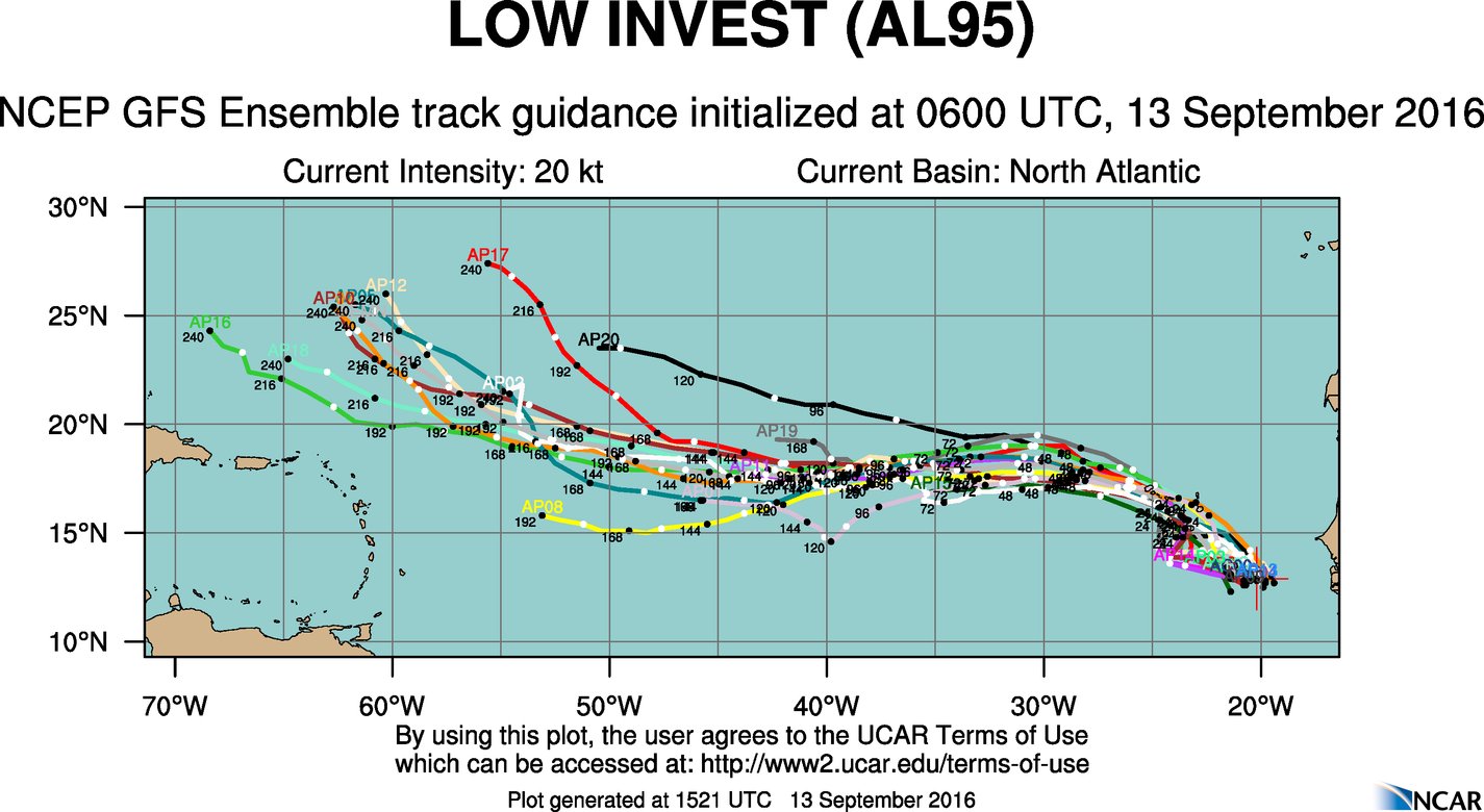
Para cuando llegue a la 25W debe estar por la 16N, no por mi sino por pronósticos de los modelos. Mas tarde entraré de nuevo a ver si subio tanto.
-
StormWatch
- Cat. 3
- Posts: 3721
- Joined: Thu Aug 06, 2015 11:39 am
- Location: Texas, USA
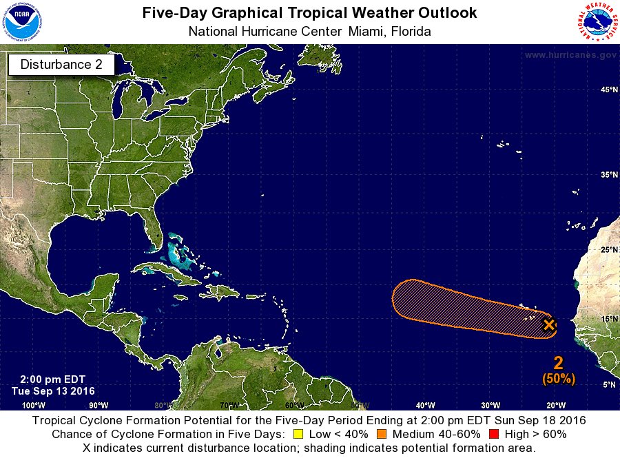
Re: Invest 95L 30%-50% Anaranjado (Pouch 34L)
At 2pm
A broad area of low pressure, associated with a tropical wave,
located a couple of hundred miles east-southeast of the Cabo Verde
Islands is producing a large area of disorganized cloudiness and
showers. Slow development of this disturbance is possible during
the next several days while it moves west-northwestward at 10 to 15
mph over the tropical Atlantic. Regardless of development, locally
heavy rains and gusty winds are likely over portions of the Cabo
Verde Islands through Wednesday.
* Formation chance through 48 hours...low...30 percent
* Formation chance through 5 days...medium...50 percent
Member Since 2005
For official information, please refer to NHC: https://www.nhc.noaa.gov
Hurricane’s hit Puerto Rico:
San Felipe 1928, San Ciprián 1932, Santa Clara 1956, Hugo 1989, Marilyn 1995, Hortense 1996, Georges 1998, Maria 2017, Fiona 2022
Model Runs:
GFS:
[5:30 AM/PM, 11:30 AM/PM]
HWRF, GFDL, UKMET, NAVGEM:
[6:30-8:00 AM/PM, 12:30-2:00 AM/PM]
ECMWF:
[1:45 AM/PM]
For official information, please refer to NHC: https://www.nhc.noaa.gov
Hurricane’s hit Puerto Rico:
San Felipe 1928, San Ciprián 1932, Santa Clara 1956, Hugo 1989, Marilyn 1995, Hortense 1996, Georges 1998, Maria 2017, Fiona 2022
Model Runs:
GFS:
[5:30 AM/PM, 11:30 AM/PM]
HWRF, GFDL, UKMET, NAVGEM:
[6:30-8:00 AM/PM, 12:30-2:00 AM/PM]
ECMWF:
[1:45 AM/PM]
-
StormWatch
- Cat. 3
- Posts: 3721
- Joined: Thu Aug 06, 2015 11:39 am
- Location: Texas, USA
Re: Invest 95L 30%-50% Anaranjado (Pouch 34L)
Esperando q ese cono del NHC llegue maybe a las Antillas Menores!
Member Since 2005
For official information, please refer to NHC: https://www.nhc.noaa.gov
Hurricane’s hit Puerto Rico:
San Felipe 1928, San Ciprián 1932, Santa Clara 1956, Hugo 1989, Marilyn 1995, Hortense 1996, Georges 1998, Maria 2017, Fiona 2022
Model Runs:
GFS:
[5:30 AM/PM, 11:30 AM/PM]
HWRF, GFDL, UKMET, NAVGEM:
[6:30-8:00 AM/PM, 12:30-2:00 AM/PM]
ECMWF:
[1:45 AM/PM]
For official information, please refer to NHC: https://www.nhc.noaa.gov
Hurricane’s hit Puerto Rico:
San Felipe 1928, San Ciprián 1932, Santa Clara 1956, Hugo 1989, Marilyn 1995, Hortense 1996, Georges 1998, Maria 2017, Fiona 2022
Model Runs:
GFS:
[5:30 AM/PM, 11:30 AM/PM]
HWRF, GFDL, UKMET, NAVGEM:
[6:30-8:00 AM/PM, 12:30-2:00 AM/PM]
ECMWF:
[1:45 AM/PM]
-
StormWatch
- Cat. 3
- Posts: 3721
- Joined: Thu Aug 06, 2015 11:39 am
- Location: Texas, USA
Re: Invest 95L 30%-50% Anaranjado (Pouch 34L)
Que triste esta la temporada de huracanes..............
Según los modelitos, la futura Julia se va rumbo al Norte.....................
Según los modelitos, la futura Julia se va rumbo al Norte.....................
Member Since 2005
For official information, please refer to NHC: https://www.nhc.noaa.gov
Hurricane’s hit Puerto Rico:
San Felipe 1928, San Ciprián 1932, Santa Clara 1956, Hugo 1989, Marilyn 1995, Hortense 1996, Georges 1998, Maria 2017, Fiona 2022
Model Runs:
GFS:
[5:30 AM/PM, 11:30 AM/PM]
HWRF, GFDL, UKMET, NAVGEM:
[6:30-8:00 AM/PM, 12:30-2:00 AM/PM]
ECMWF:
[1:45 AM/PM]
For official information, please refer to NHC: https://www.nhc.noaa.gov
Hurricane’s hit Puerto Rico:
San Felipe 1928, San Ciprián 1932, Santa Clara 1956, Hugo 1989, Marilyn 1995, Hortense 1996, Georges 1998, Maria 2017, Fiona 2022
Model Runs:
GFS:
[5:30 AM/PM, 11:30 AM/PM]
HWRF, GFDL, UKMET, NAVGEM:
[6:30-8:00 AM/PM, 12:30-2:00 AM/PM]
ECMWF:
[1:45 AM/PM]
-
StormWatch
- Cat. 3
- Posts: 3721
- Joined: Thu Aug 06, 2015 11:39 am
- Location: Texas, USA
Re: Invest 95L 30%-50% Anaranjado (Pouch 34L)
Lo mismo............
Member Since 2005
For official information, please refer to NHC: https://www.nhc.noaa.gov
Hurricane’s hit Puerto Rico:
San Felipe 1928, San Ciprián 1932, Santa Clara 1956, Hugo 1989, Marilyn 1995, Hortense 1996, Georges 1998, Maria 2017, Fiona 2022
Model Runs:
GFS:
[5:30 AM/PM, 11:30 AM/PM]
HWRF, GFDL, UKMET, NAVGEM:
[6:30-8:00 AM/PM, 12:30-2:00 AM/PM]
ECMWF:
[1:45 AM/PM]
For official information, please refer to NHC: https://www.nhc.noaa.gov
Hurricane’s hit Puerto Rico:
San Felipe 1928, San Ciprián 1932, Santa Clara 1956, Hugo 1989, Marilyn 1995, Hortense 1996, Georges 1998, Maria 2017, Fiona 2022
Model Runs:
GFS:
[5:30 AM/PM, 11:30 AM/PM]
HWRF, GFDL, UKMET, NAVGEM:
[6:30-8:00 AM/PM, 12:30-2:00 AM/PM]
ECMWF:
[1:45 AM/PM]
-
StormWatch
- Cat. 3
- Posts: 3721
- Joined: Thu Aug 06, 2015 11:39 am
- Location: Texas, USA
Re: Invest 95L 30%-50% Anaranjado (Pouch 34L)
Invest 95L

Member Since 2005
For official information, please refer to NHC: https://www.nhc.noaa.gov
Hurricane’s hit Puerto Rico:
San Felipe 1928, San Ciprián 1932, Santa Clara 1956, Hugo 1989, Marilyn 1995, Hortense 1996, Georges 1998, Maria 2017, Fiona 2022
Model Runs:
GFS:
[5:30 AM/PM, 11:30 AM/PM]
HWRF, GFDL, UKMET, NAVGEM:
[6:30-8:00 AM/PM, 12:30-2:00 AM/PM]
ECMWF:
[1:45 AM/PM]
For official information, please refer to NHC: https://www.nhc.noaa.gov
Hurricane’s hit Puerto Rico:
San Felipe 1928, San Ciprián 1932, Santa Clara 1956, Hugo 1989, Marilyn 1995, Hortense 1996, Georges 1998, Maria 2017, Fiona 2022
Model Runs:
GFS:
[5:30 AM/PM, 11:30 AM/PM]
HWRF, GFDL, UKMET, NAVGEM:
[6:30-8:00 AM/PM, 12:30-2:00 AM/PM]
ECMWF:
[1:45 AM/PM]