

Depresión Tropical Karl (Invest 95L)

Re: Tormenta Tropical Karl (Invest 95L)
Pero como es eso!!! 
-
StormWatch
- Cat. 3

- Posts: 3721
- Joined: Thu Aug 06, 2015 11:39 am
- Location: Texas, USA
Re: Tormenta Tropical Karl (Invest 95L)
YankeeStorm wrote:Leannnnnnnn bien por aqui lean bien por favor
Puerto Rico estara bajo aviso de huracan
Aviso de huracán categoría 5?

Member Since 2005
For official information, please refer to NHC: https://www.nhc.noaa.gov
Hurricane’s hit Puerto Rico:
San Felipe 1928, San Ciprián 1932, Santa Clara 1956, Hugo 1989, Marilyn 1995, Hortense 1996, Georges 1998, Maria 2017, Fiona 2022
Model Runs:
GFS:
[5:30 AM/PM, 11:30 AM/PM]
HWRF, GFDL, UKMET, NAVGEM:
[6:30-8:00 AM/PM, 12:30-2:00 AM/PM]
ECMWF:
[1:45 AM/PM]
-
StormWatch
- Cat. 3
- Posts: 3721
- Joined: Thu Aug 06, 2015 11:39 am
- Location: Texas, USA
Re: Tormenta Tropical Karl (Invest 95L)
Due WEST!
11pm
11pm
Member Since 2005
For official information, please refer to NHC: https://www.nhc.noaa.gov
Hurricane’s hit Puerto Rico:
San Felipe 1928, San Ciprián 1932, Santa Clara 1956, Hugo 1989, Marilyn 1995, Hortense 1996, Georges 1998, Maria 2017, Fiona 2022
Model Runs:
GFS:
[5:30 AM/PM, 11:30 AM/PM]
HWRF, GFDL, UKMET, NAVGEM:
[6:30-8:00 AM/PM, 12:30-2:00 AM/PM]
ECMWF:
[1:45 AM/PM]
For official information, please refer to NHC: https://www.nhc.noaa.gov
Hurricane’s hit Puerto Rico:
San Felipe 1928, San Ciprián 1932, Santa Clara 1956, Hugo 1989, Marilyn 1995, Hortense 1996, Georges 1998, Maria 2017, Fiona 2022
Model Runs:
GFS:
[5:30 AM/PM, 11:30 AM/PM]
HWRF, GFDL, UKMET, NAVGEM:
[6:30-8:00 AM/PM, 12:30-2:00 AM/PM]
ECMWF:
[1:45 AM/PM]
-
StormWatch
- Cat. 3
- Posts: 3721
- Joined: Thu Aug 06, 2015 11:39 am
- Location: Texas, USA
Re: Tormenta Tropical Karl (Invest 95L)
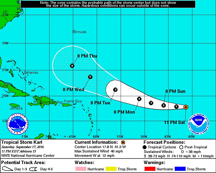
000
WTNT32 KNHC 180230
TCPAT2
BULLETIN
TROPICAL STORM KARL ADVISORY NUMBER 15
NWS NATIONAL HURRICANE CENTER MIAMI FL AL122016
1100 PM AST SAT SEP 17 2016
...KARL STRUGGLING OVER THE CENTRAL ATLANTIC...
SUMMARY OF 1100 PM AST...0300 UTC...INFORMATION
-----------------------------------------------
LOCATION...17.8N 41.3W
ABOUT 1350 MI...2175 KM E OF THE LEEWARD ISLANDS
MAXIMUM SUSTAINED WINDS...40 MPH...65 KM/H
PRESENT MOVEMENT...W OR 265 DEGREES AT 12 MPH...19 KM/H
MINIMUM CENTRAL PRESSURE...1006 MB...29.71 INCHES
WATCHES AND WARNINGS
--------------------
There are no coastal watches or warnings in effect.
DISCUSSION AND 48-HOUR OUTLOOK
------------------------------
At 1100 PM AST (0300 UTC), the center of Tropical Storm Karl was
located near latitude 17.8 North, longitude 41.3 West. Karl is
moving toward the west near 12 mph (19 km/h). A westward to
west-northwestward motion with some increase in forward speed is
expected during the next couple of days.
Maximum sustained winds have decreased to near 40 mph (65 km/h) with
higher gusts. Karl is forecast to begin to strengthen on Monday.
Tropical-storm-force winds extend outward up to 230 miles (370 km)
northeast of the center.
The estimated minimum central pressure is 1006 mb (29.71 inches).
HAZARDS AFFECTING LAND
----------------------
None.
NEXT ADVISORY
-------------
Next complete advisory at 500 AM AST.
$$
Forecaster Cangialosi
Member Since 2005
For official information, please refer to NHC: https://www.nhc.noaa.gov
Hurricane’s hit Puerto Rico:
San Felipe 1928, San Ciprián 1932, Santa Clara 1956, Hugo 1989, Marilyn 1995, Hortense 1996, Georges 1998, Maria 2017, Fiona 2022
Model Runs:
GFS:
[5:30 AM/PM, 11:30 AM/PM]
HWRF, GFDL, UKMET, NAVGEM:
[6:30-8:00 AM/PM, 12:30-2:00 AM/PM]
ECMWF:
[1:45 AM/PM]
For official information, please refer to NHC: https://www.nhc.noaa.gov
Hurricane’s hit Puerto Rico:
San Felipe 1928, San Ciprián 1932, Santa Clara 1956, Hugo 1989, Marilyn 1995, Hortense 1996, Georges 1998, Maria 2017, Fiona 2022
Model Runs:
GFS:
[5:30 AM/PM, 11:30 AM/PM]
HWRF, GFDL, UKMET, NAVGEM:
[6:30-8:00 AM/PM, 12:30-2:00 AM/PM]
ECMWF:
[1:45 AM/PM]
-
StormWatch
- Cat. 3
- Posts: 3721
- Joined: Thu Aug 06, 2015 11:39 am
- Location: Texas, USA
Re: Tormenta Tropical Karl (Invest 95L)
000
WTNT42 KNHC 180231
TCDAT2
TROPICAL STORM KARL DISCUSSION NUMBER 15
NWS NATIONAL HURRICANE CENTER MIAMI FL AL122016
1100 PM AST SAT SEP 17 2016
Karl continues to struggle. The tropical storm is producing a few
patches of deep convection to the north and east of the exposed
center, but the cyclone lacks banding features. An ASCAT-B pass
just prior to 0000Z captured a portion of the circulation and showed
that the winds were lower there than they were in the previous pass.
Based on that data and the Dvorak classifications, the initial wind
speed is lowered a little to 35 kt.
The poor structure of Karl is likely due to the combined effects of
southwesterly shear and dry mid-level air. These unfavorable
atmospheric conditions and marginally warm sea surface temperatures
should keep Karl relatively steady state for the next day or so.
After that time, lower shear, slightly more moisture, and warmer sea
surface temperatures should allow the cyclone to strengthen. The
intensity models are a bit higher this cycle at the longer range,
and the NHC forecast has been nudged upward. This prediction lies
near the lower end of the guidance, in best agreement with the SHIPS
model.
The center of Karl is moving south of due west at about 10 kt. A
general westward motion at a slightly faster pace is expected
during the next day or two while Karl is steered by the flow on the
south side of a subtropical ridge. A turn to the west-northwest is
predicted beyond a couple of days as Karl moves on the southwestern
periphery of the ridge and toward a weakness. There is not a
significant amount of spread in the models, or the ensemble members
of the GFS and ECMWF, and the official forecast is largely an
update of the previous one.
FORECAST POSITIONS AND MAX WINDS
INIT 18/0300Z 17.8N 41.3W 35 KT 40 MPH
12H 18/1200Z 17.9N 43.3W 35 KT 40 MPH
24H 19/0000Z 18.1N 46.0W 40 KT 45 MPH
36H 19/1200Z 18.6N 48.6W 45 KT 50 MPH
48H 20/0000Z 19.4N 51.1W 50 KT 60 MPH
72H 21/0000Z 21.2N 56.1W 55 KT 65 MPH
96H 22/0000Z 23.7N 61.4W 65 KT 75 MPH
120H 23/0000Z 25.8N 65.2W 75 KT 85 MPH
$$
Forecaster Cangialosi
Member Since 2005
For official information, please refer to NHC: https://www.nhc.noaa.gov
Hurricane’s hit Puerto Rico:
San Felipe 1928, San Ciprián 1932, Santa Clara 1956, Hugo 1989, Marilyn 1995, Hortense 1996, Georges 1998, Maria 2017, Fiona 2022
Model Runs:
GFS:
[5:30 AM/PM, 11:30 AM/PM]
HWRF, GFDL, UKMET, NAVGEM:
[6:30-8:00 AM/PM, 12:30-2:00 AM/PM]
ECMWF:
[1:45 AM/PM]
For official information, please refer to NHC: https://www.nhc.noaa.gov
Hurricane’s hit Puerto Rico:
San Felipe 1928, San Ciprián 1932, Santa Clara 1956, Hugo 1989, Marilyn 1995, Hortense 1996, Georges 1998, Maria 2017, Fiona 2022
Model Runs:
GFS:
[5:30 AM/PM, 11:30 AM/PM]
HWRF, GFDL, UKMET, NAVGEM:
[6:30-8:00 AM/PM, 12:30-2:00 AM/PM]
ECMWF:
[1:45 AM/PM]
-
StormWatch
- Cat. 3
- Posts: 3721
- Joined: Thu Aug 06, 2015 11:39 am
- Location: Texas, USA
Re: Tormenta Tropical Karl (Invest 95L)
Hmmmmmmmmmmmmm interesting... 

Member Since 2005
For official information, please refer to NHC: https://www.nhc.noaa.gov
Hurricane’s hit Puerto Rico:
San Felipe 1928, San Ciprián 1932, Santa Clara 1956, Hugo 1989, Marilyn 1995, Hortense 1996, Georges 1998, Maria 2017, Fiona 2022
Model Runs:
GFS:
[5:30 AM/PM, 11:30 AM/PM]
HWRF, GFDL, UKMET, NAVGEM:
[6:30-8:00 AM/PM, 12:30-2:00 AM/PM]
ECMWF:
[1:45 AM/PM]
For official information, please refer to NHC: https://www.nhc.noaa.gov
Hurricane’s hit Puerto Rico:
San Felipe 1928, San Ciprián 1932, Santa Clara 1956, Hugo 1989, Marilyn 1995, Hortense 1996, Georges 1998, Maria 2017, Fiona 2022
Model Runs:
GFS:
[5:30 AM/PM, 11:30 AM/PM]
HWRF, GFDL, UKMET, NAVGEM:
[6:30-8:00 AM/PM, 12:30-2:00 AM/PM]
ECMWF:
[1:45 AM/PM]

Re: Tormenta Tropical Karl (Invest 95L)
YankeeStorm wrote:Leannnnnnnn bien por aqui lean bien por favor
Puerto Rico estara bajo aviso de huracan
-
ROCKstormSJ4315

- Tormenta Tropical

- Posts: 888
- Joined: Tue Aug 06, 2013 10:09 pm
- Location: Hato Rey, San Juan, PR
Re: Tormenta Tropical Karl (Invest 95L)
Esto lo amplio durante el dia pues es muy tarde, pero segun va lo que trabajo en "Hurricane University", donde la muestra va subiendo, esto es lo que sale a las 5AM:17.7 y 44.09, 17.74 y 46.87,18.56 y 49.58, 20.06 y 53.67, 21.72 y 55.60, 23.75 y 60.23, 25 y 63.8.
No van tan lejos al estimado oficial del NHC, pero sigue saliendo incertidumbre a largo plazo y algo de atraso en el cambio al NO. Hasta 72 horas, se parecen mucho.
No obstante, la desviacion standard para la latitud ha ido subiendo. Como mas incertidumbre con la latitud a largo plazo. Alla en el otro topico ampliare mas tarde.
Nota: Recuerde que la informacion oficial es la que esta debajo. Lo de arriba es el analisis estadistico de un aficionado.
Aqui el ultimo TWO del NHC de las 5AM y como compara con estos datos estadisticos:
"TROPICAL STORM KARL DISCUSSION NUMBER 16
NWS NATIONAL HURRICANE CENTER MIAMI FL AL122016
500 AM AST SUN SEP 18 2016
The structure of Karl has kept a similar appearance for some time
now with a small area of convection flaring up and down near the
center, with a larger mass of thunderstorms following the center in
the northeastern quadrant. The initial wind speed is held at 35 kt
using the last TAFB satellite estimate.
Karl's disorganized low-level structure will likely prevent much
intensification in the short term. However the environment
near the tropical cyclone is likely to become conducive for
strengthening within a couple of days due to lower shear, slightly
more moisture, and warmer sea surface temperatures. The intensity
guidance is very similar to the previous model cycle, and only
small changes were made to the previous NHC wind speed forecast.
The initial motion estimate is 255/10. A large subtropical high
over the central Atlantic should provide a fairly well-defined
steering current for the tropical storm over the next several days.
This ridge will likely turn Karl to the west later today and to the
west-northwest by early Tuesday through the end of the period.
Other than a small westward adjustment through 72 hours, the new
NHC track is similar to the previous one, near a model consensus
favoring the faster GFS/ECMWF solutions.
FORECAST POSITIONS AND MAX WINDS
INIT 18/0900Z 17.7N 42.3W 35 KT 40 MPH
12H 18/1800Z 17.7N 44.3W 35 KT 40 MPH
24H 19/0600Z 18.0N 47.0W 40 KT 45 MPH
36H 19/1800Z 18.6N 49.6W 40 KT 45 MPH
48H 20/0600Z 19.3N 52.2W 45 KT 50 MPH
72H 21/0600Z 21.5N 57.2W 55 KT 65 MPH
96H 22/0600Z 23.9N 62.1W 65 KT 75 MPH
120H 23/0600Z 26.5N 66.5W 75 KT 85 MPH
$$
Forecaster Blake"
"Georgy Girl", The Seekers
"Back for Good", Take That
"Perfectionist", SAGA
"Graves Into Gardens", Elevation Worship ft. Brandon Lake
"Thunder", Imagine Dragons
"Viva la Vida", Coldplay
"Back for Good", Take That
"Perfectionist", SAGA
"Graves Into Gardens", Elevation Worship ft. Brandon Lake
"Thunder", Imagine Dragons
"Viva la Vida", Coldplay
-
StormWatch
- Cat. 3
- Posts: 3721
- Joined: Thu Aug 06, 2015 11:39 am
- Location: Texas, USA
Re: Tormenta Tropical Karl (Invest 95L)
000
WTNT32 KNHC 180840
TCPAT2
BULLETIN
TROPICAL STORM KARL ADVISORY NUMBER 16
NWS NATIONAL HURRICANE CENTER MIAMI FL AL122016
500 AM AST SUN SEP 18 2016
...KARL FORECAST TO STRENGTHEN ON MONDAY...
SUMMARY OF 500 AM AST...0900 UTC...INFORMATION
----------------------------------------------
LOCATION...17.7N 42.3W
ABOUT 1285 MI...2070 KM E OF THE LEEWARD ISLANDS
MAXIMUM SUSTAINED WINDS...40 MPH...65 KM/H
PRESENT MOVEMENT...W OR 265 DEGREES AT 13 MPH...20 KM/H
MINIMUM CENTRAL PRESSURE...1006 MB...29.71 INCHES
WATCHES AND WARNINGS
--------------------
There are no coastal watches or warnings in effect.
DISCUSSION AND 48-HOUR OUTLOOK
------------------------------
At 500 AM AST (0900 UTC), the center of Tropical Storm Karl was
located near latitude 17.7 North, longitude 42.3 West. Karl is
moving toward the west near 13 mph (20 km/h). A westward to
west-northwestward motion with some increase in forward speed is
expected during the next couple of days.
Maximum sustained winds are near 40 mph (65 km/h) with higher gusts.
Karl is forecast to begin to strengthen on Monday.
Tropical-storm-force winds extend outward up to 230 miles (370 km)
from the center.
The estimated minimum central pressure is 1006 mb (29.71 inches).
HAZARDS AFFECTING LAND
----------------------
None.
NEXT ADVISORY
-------------
Next complete advisory at 1100 AM AST.
$$
Forecaster Blake
Member Since 2005
For official information, please refer to NHC: https://www.nhc.noaa.gov
Hurricane’s hit Puerto Rico:
San Felipe 1928, San Ciprián 1932, Santa Clara 1956, Hugo 1989, Marilyn 1995, Hortense 1996, Georges 1998, Maria 2017, Fiona 2022
Model Runs:
GFS:
[5:30 AM/PM, 11:30 AM/PM]
HWRF, GFDL, UKMET, NAVGEM:
[6:30-8:00 AM/PM, 12:30-2:00 AM/PM]
ECMWF:
[1:45 AM/PM]
For official information, please refer to NHC: https://www.nhc.noaa.gov
Hurricane’s hit Puerto Rico:
San Felipe 1928, San Ciprián 1932, Santa Clara 1956, Hugo 1989, Marilyn 1995, Hortense 1996, Georges 1998, Maria 2017, Fiona 2022
Model Runs:
GFS:
[5:30 AM/PM, 11:30 AM/PM]
HWRF, GFDL, UKMET, NAVGEM:
[6:30-8:00 AM/PM, 12:30-2:00 AM/PM]
ECMWF:
[1:45 AM/PM]