¡Bienvenidos a la nueva interface gráfica de CycloForums!
Search
Go to advanced search
- by Migdalia
- Sat Aug 06, 2022 8:20 pm
- Forum: Ciclón Caribe
- Topic: Área de interés en el Atlántico
- Replies: 6
- Views: 17208
https://i.postimg.cc/qvWS0GRk/two-6-agosto-2022-8pm.png Tropical Weather Outlook NWS National Hurricane Center Miami FL 800 PM EDT Sat Aug 6 2022 For the North Atlantic...Caribbean Sea and the Gulf of Mexico: 1. Eastern Tropical Atlantic: A tropical wave is forecast to move off the west coast of Af...
- by Migdalia
- Sat Aug 06, 2022 2:57 pm
- Forum: Ciclón Caribe
- Topic: Área de interés en el Atlántico
- Replies: 6
- Views: 17208
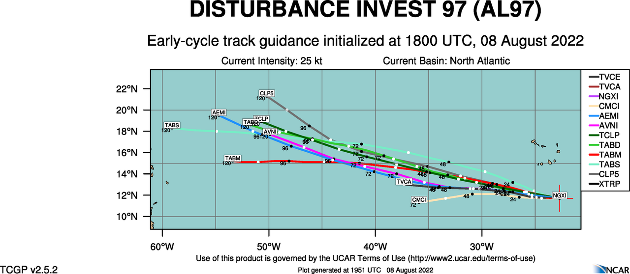
Saludos a todos, el Atlántico empieza a despertar y nos trae algo para monitorear. https://i.postimg.cc/g2yx9NP0/two-6-agosto-2022-2pm.png Tropical Weather Outlook NWS National Hurricane Center Miami FL 200 PM EDT Sat Aug 6 2022 For the North Atlantic...Caribbean Sea and the Gulf of Mexico: 1. East...
- by Migdalia
- Tue Jun 28, 2022 10:13 am
- Forum: Ciclón Caribe
- Topic: Ahora cambia a: ¿posible 96L?
- Replies: 6
- Views: 16664
https://i.postimg.cc/4ysGKM1w/two-8am-28-junio-2022.png Tropical Weather Outlook NWS National Hurricane Center Miami FL 800 AM EDT Tue Jun 28 2022 Central Tropical Atlantic: 2. A tropical wave located more than 1000 miles east of the Windward Islands continues to produce disorganized showers and th...
- by Migdalia
- Mon Jun 27, 2022 5:01 am
- Forum: Ciclón Caribe
- Topic: Ahora cambia a: ¿posible 96L?
- Replies: 6
- Views: 16664
El Atlántico calentando sus motores. La onda detrás del 94L ya recibió su pinturita. Esta podría ser de mayor interés para nuestra isla. ¿Será el próximo 95L? Ya veremos.
Lindo día a todos.
- by Migdalia
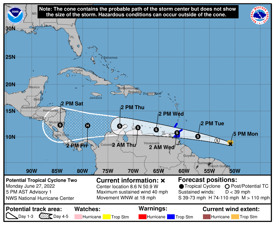
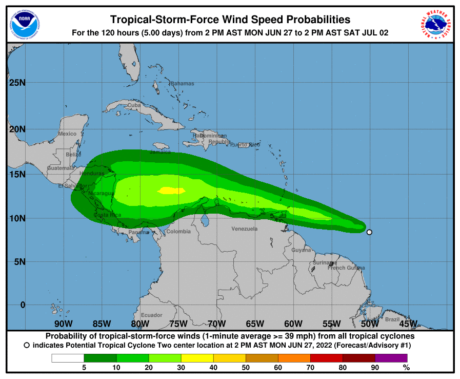
- Mon Jun 27, 2022 4:49 am
- Forum: Ciclón Caribe
- Topic: POTENTIAL TROPICAL CYCLONE TWO
- Replies: 9
- Views: 19325
Saludos a todos! Migdalia por favor verifica que los emails del administrador del foro no se vayan a spam. He estado respondiendo a los mensajes que enviaste por los problemas con tu cuenta. Saludos! Saludos José (Obi-Wan). Perfecto, acabo de cotejar y como vez ya tengo acceso a mi cuenta y como ev...
- by Migdalia
- Fri Jun 24, 2022 4:48 am
- Forum: Ciclón Caribe
- Topic: POTENTIAL TROPICAL CYCLONE TWO
- Replies: 9
- Views: 19325
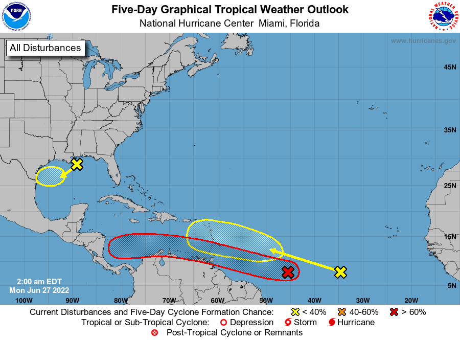
Saludos a todos. Tempranito en la temporada algo para monitorear. Si empezamos así, la temporada 2022 podría prometer días interesantes. Sólo el tiempo dirá. https://i.postimg.cc/xjZBDgHW/94-L-2am-24-junio-2022-TWO.png https://i.postimg.cc/43KB5R2y/94-L-2am-24-junio-2022.png https://i.postimg.cc/xC...
- by Migdalia
- Fri Aug 10, 2018 9:14 am
- Forum: Ciclón Caribe
- Topic: Invest 99L al este de las Antillas Menores - 10 / 20
- Replies: 13
- Views: 3100
https://imageshack.com/a/img924/9315/rd4VnH.png https://imageshack.com/a/img923/6472/09R2l4.png Tropical Weather Outlook NWS National Hurricane Center Miami FL 800 AM EDT Fri Aug 10 2018 For the North Atlantic...Caribbean Sea and the Gulf of Mexico: 1. An area of disturbed weather is located about ...
- by Migdalia
- Thu Aug 31, 2017 3:53 pm
- Forum: Ciclón Caribe
- Topic: Huracán Irma
- Replies: 2720
- Views: 142550
DATE/TIME LAT LON CLASSIFICATION STORM 31/1745 UTC 17.1N 34.1W T5.5/5.5 IRMA :shock: Para referencia: CI MWS MWS MSLP MSLP Saffir-Simpson Number (Knots) (MPH) (Atlantic) (NW Pacific) Category 1 25 KTS 29 MPH (Approximate) 1.5 25 KTS 29 MPH 2 30 KTS 35 MPH 1009 mb 1000 mb 2.5 35 KTS 40 MPH 1005 mb 9...